Carne, Cornwall
Coordinates: 50°04′55″N 5°06′58″W / 50.082°N 5.116°W Carne is a hamlet in the civil parish of St Anthony-in-Meneage, Cornwall, England, UK.[1]
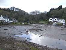
Head of Gillan Creek - geograph.org.uk - 411782
According to the Post Office the population at the 2011 census was located in the civil parish of Veryan
Carne lies on the south side of Gillan Creek at around 30 feet (9.1 m) above sea level.[1] Gillan Creek is a part of the Lower Fal and Helford Tidal Site of Special Scientific Interest. Carne lies within the Cornwall Area of Outstanding Natural Beauty (AONB). Almost a third of Cornwall has AONB designation, with the same status and protection as a National Park.
References
- 1 2 "DEFRA Magic Map Application". DEFRA. Retrieved 10 January 2016.
Cornwall Portal | |
| Unitary authorities | |
| Major settlements |
|
| Rivers | |
| Topics | |
This article is issued from
Wikipedia.
The text is licensed under Creative Commons - Attribution - Sharealike.
Additional terms may apply for the media files.