Carn Arthen
Coordinates: 50°12′43″N 5°16′01″W / 50.212°N 5.267°W
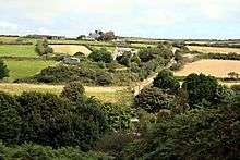
Looking over the Brea Valley to Carn Arthen
Carn Arthen (Cornish: Karn Arthur, meaning Arthur's rock-pile) is farmstead 1.7 miles (2.7 km) south-east of Camborne near to Tuckingmill in Cornwall, England.[1]
See also
References
- ↑ "DEFRA Magic Map Application". DEFRA. Retrieved 10 January 2016.
Cornwall Portal | |
| Unitary authorities | |
| Major settlements |
|
| Rivers | |
| Topics | |
This article is issued from
Wikipedia.
The text is licensed under Creative Commons - Attribution - Sharealike.
Additional terms may apply for the media files.