Avarua
Coordinates: 21°12′S 159°46′W / 21.200°S 159.767°W
| Avarua | |
|---|---|
| Town | |
 Ara Maire Nui, the main street in Avarua | |
_map.png) Location of Avatura (star) | |
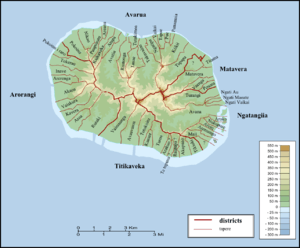 Districts and tapere of Rarotonga | |
| Country | Cook Islands |
| Island | Rarotonga |
| Population (2006) | |
| • Total | 5,445 |
| Time zone | UTC−10:00 (CKT) |
| Area code(s) | +682 |
| Climate | Af |
Avarua (meaning "Two Harbours" in Cook Islands Māori) is a town and district in the north of the island of Rarotonga, and is the national capital of the Cook Islands.
The town is served by Rarotonga International Airport (IATA Airport Code: RAR) and Avatiu Harbour.
The population of Avarua District is 5,445 (census of 2006).[1]
Districts
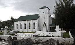 CICC church |
 Main street of Avarua looking towards the Bank of the Cook Islands (BCI) building |
Avarua is subdivided into 18 tapere out of 54 for Rarotonga, listed from west to east:
- Pokoinu
- Nikao (seat of Cook Islands parliament)
- Puapuautu
- Areanu
- Kaikaveka
- Atupa
- Avatiu (commercial port)
- Ruatonga
- Tutakimoa
- Tauae (inward from Tutakimoa, the only Tapere without a coastline)
- Takuvaine (downtown Avarua, seat of Cook Islands government, with Avarua fishing harbour)
- Ngatipa
- Vaikai
- Tapae-I-Uta
- Pue
- Punamaia
- Kiikii
- Tupapa
Census figures are not available on the tapere level, but only for the so-called Census Districts,[2] also listed from west to east [3]
- Nikao-Panama 1373 (the Taperes' of Pokoinu, Nikao, Puapuautu)
- Avatiu-Ruatonga 951 (the Taperes' of Areanu, Kaikaveka, Atupa, Avatiu, Ruatonga)
- Tutakimoa-Teotue 314 (the Taperes' of Tutakimoa)
- Takuvaine-Parekura 786 (the Taperes' of Tauae, Takuvaine)
- Tupapa-Maraerenga 531 (the Taperes' of Ngatipa, Vaikai)
- Pue-Matavera 1490 (the Taperes' of Tapae-I-Uta, Pue, Punamaia, Kiikii, Tupapa)
References
- ↑ Hassall, Graham; Tipu, Feue (28 April 2008). "Local Government in the South Pacific Islands". Commonwealth Journal of Local Governance (1): 7–29. doi:10.5130/cjlg.v1i0.766. Retrieved 2 May 2017 – via epress.lib.uts.edu.au.
- ↑ "Archived copy" (PDF). Archived from the original (PDF) on 2008-10-14. Retrieved 2008-08-29.
- ↑ P.H. Curson: "Population Change in the Cook Islands - The 1966 Population Census". In: New Zealand Geographer, Vol. 28, 1972, pp. 51-65, map p.52
External links

- Photo of Government Radio Station Rarotonga c1950
| Northern | ||
|---|---|---|
| Southern - Nga-pu-Toru | ||
| Southern - other | ||
| Authority control |
|---|
This article is issued from
Wikipedia.
The text is licensed under Creative Commons - Attribution - Sharealike.
Additional terms may apply for the media files.