Funafuti
| Funafuti | |
|---|---|
| Atoll | |
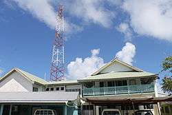
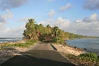
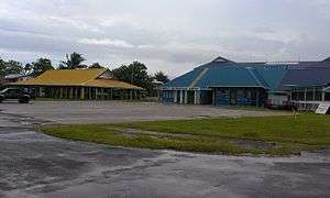 Maneapa and airport on Funafuti atoll, Tuvalu | |
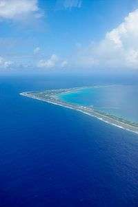
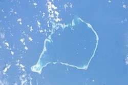 Aerial image of Funafuti atoll | |
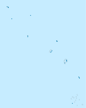 Funafuti Location of Funafuti atoll in Tuvalu | |
| Coordinates: 08°31′S 179°12′E / 8.517°S 179.200°ECoordinates: 08°31′S 179°12′E / 8.517°S 179.200°E | |
| Country | Tuvalu |
| Area | |
| • Total | 2.4 km2 (0.9 sq mi) |
| Population (2012) | |
| • Total | 6,025 |
| • Density | 2,500/km2 (6,500/sq mi) |
| ISO 3166 code | TV-FUN |
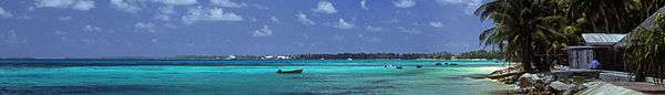
Funafuti is an atoll on which the capital of the island nation of Tuvalu is located.[1][2] It has a population of 6,025 people,[3] making it the country's most populated atoll, with 56.6 percent of Tuvalu's population. It is a narrow sweep of land between 20 and 400 metres (66 and 1,312 feet) wide, encircling a large lagoon (Te Namo) 18 km (11 miles) long and 14 km (9 miles) wide. The average depth in the Funafuti lagoon is about 20 fathoms (36.5 metres or 120 feet).[4] With a surface of 275 square kilometres (106.2 sq mi), it is by far the largest lagoon in Tuvalu. The land area of the 33 islets aggregates to 2.4 square kilometres (0.9 sq mi), less than one percent of the total area of the atoll. Cargo ships can enter Funafuti's lagoon and dock at the port facilities on Fongafale.
The capital of Tuvalu is sometimes given as Fongafale or Vaiaku, however the entire atoll of Funafuti is officially the capital, since it comprises a single local government.
Fongafale
The largest island is Fongafale. The island houses four villages and community meeting places. The Funafuti Falekaupule is the local council, with the Kaupule as the executive of the Falekaupule.[5] On Fongafale, the Funafuti Kaupule is responsible for approvals of the construction of houses or extension to an existing buildings on private land and the Lands Management Committee is the responsible authority in relation to lands leased by Government.[6]
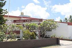
Tausoa Lima Falekaupule is the traditional meeting house on Funafuti – Tausoalima means "hand of friendship" and Falekaupule means "traditional island meeting hall." There is the Vaiaku Langi Hotel, and other guesthouses as well as homes, constructed both in the traditional manner, out of palm fronds, and more recently out of cement blocks. The most prominent building on Funafuti atoll is the Fetu Ao Lima (Morning Star Church) of the Church of Tuvalu.
Other sites of interest are the remains of Japanese aircraft that crashed on Funafuti during World War II. The airfield was constructed during World War II and is now the Funafuti International Airport, which serves both as the airstrip for the flights from Fiji as well as providing a place for sporting and other recreational activities.
A major sporting event is the "Independence Day Sports Festival" held annually at Fongafale on 1 October. The most important sports event within the country is arguably the Tuvalu Games, which are held yearly since 2008 with teams coming to Funafuti from the outer islands to compete in the games.[7] Football in Tuvalu is played at club and national team level. The Tuvalu national football team trains at the Tuvalu Sports Ground on Funafuti and competes in the Pacific Games and South Pacific Games.
The Parliament of Tuvalu or Palamene o Tuvalu is located on Fongafale together with the offices of the government departments and the government agencies including the Tuvalu Telecommunications Corporation, National Bank of Tuvalu, Tuvalu Philatelic Bureau, Tuvalu Meteorological Service, Tuvalu National Library and Archives and the Tuvalu Media Department that operates Radio Tuvalu. The police service has its headquarters on Fongafale. The High Court of Tuvalu is also located on Fongafale, as well as the jail. The Princess Margaret Hospital, which is the only hospital in Tuvalu, is located on Fongafale.
Villages on Funafuti
The individual villages of the atoll with population, according to the census of population 2012,[3] by islet:
Central Fongafale islet
- Fakaifou: 1,158 inhabitants
- Senala: 1,207 inhabitants
- Alapi: 1,029 inhabitants
- Vaiaku: 638 inhabitants
Rest of Fongafale islet
Including the Tengako peninsula in the north:
- Lofeagai: 627 inhabitants
- Teone: 570 inhabitants
- Tekavatoetoe: 650 inhabitants
Funafala
- Funafala: 50 inhabitants
Amatuku
- Amatuku: 182 inhabitants
Funafuti Marine Conservation Area
In June 1996, the Funafuti Conservation Area was established along the western rim of the reef, encompassing six islets. It has an area of 33 km², containing 20 percent of the reef area of Funafuti. The land area of the six islets in the conservation area is 8 ha (0.08 km²). The islets in the conservation area, from north to south, with estimated area in hectares:
- Tepuka Vilivili, 3
- Fualopa, 2
- Fuafatu, 0.2
- Vasafua, 0.5
- Fuakea, 1.5
- Tefala, 1
Access to the Funafuti Conservation Area is by boat; the Conservation Area is 15 kilometres (9.3 mi) across the lagoon from the main island of Fongafale.
Islands in Funafuti
There are at least 29 islets in the atoll.[1] The biggest is Fongafale, followed by Funafala. At least three islands are inhabited, which are Fongafale, the main island in the east, Funafala in the south, and Amatuku in the north.
- Amatuku
- Avalau
- Falaoigo
- Fale Fatu (or Falefatu)
- Fatato
- Fongafale
- Fuafatu
- Fuagea
- Fualefeke (or Fualifeke)
- Fualopa
- Funafala
- Funamanu
- Luamotu
- Mateika
- Motugie
- Motuloa
- Mulitefala
- Papa Elise (or Funangongo)
- Pukasavilivili
- Te Afuafou
- Te Afualiku
- Tefala
- Telele
- Tengako (peninsula of the island of Fongafale)
- Tengasu
- Tepuka
- Tepuka Vili Vili
- Tutanga
- Vasafua
Passages of Funafuti Atoll
The atoll has several passages with varying degrees of navigability that lead into the lagoon. The passes are listed clockwise, starting south of Fongafale islet. The first two clearly separate the southern part of Funafuti Atoll from the rest.[8]
- Te Ava Pua Pua, with a least depth of 12.7 metres, between the islets of Funamanu to the north and Fale Fatu to the south, in the southeast, separating the southern part of the atoll in the east
- Te Ava Fuagea, also known as Ava Amelia, is a deep and narrow passage on the southwestern side of the atoll, 18.3 metres deep and 160 metres wide, separating the southern part of the atoll in the west, south of passage Te Ava Papa and the still more northerly islet of Fuafatu, and north of the islet of Vasafua
- Te Ava Papa (just north of Te Ava Fuagea)
- Te Ava Kum Kum is in the middle of the western rim, south of Te Ava Tepuka Vili, between the islets of Tepuka Vili Vili to the north and Fualopa immediately south
- Te Ava Tepuka Vili, a deep and narrow channel, between the islets of Tepuka to the north, and Tepuka Vili Vili to the south
- Te Ava Tepuka and Te Avua Sari are two neighbouring passes in the northeast, between the islets of Te Afualiku to the northeast and Tepuka to the southwest
- Te Ava i te Lape is the favoured entrance into the lagoon, although it has a depth of only 5.8 metres, and a width of barely 500 metres. It is in the north, between the islets of Pava to the east and Te Afualiku to the west.
Lagoon
The lagoon (Te Namo in Tuvaluan) of Funafuti atoll has a north-south length of 24.5 km, and east-west 17.5 km, with an area of 275 km², making it by far the largest lagoon of Tuvalu. It is up to 52 metres deep, but has several submerged rocks and reefs that are as close as 6 metres to the surface.[9]
Climate
Funafuti features a tropical rainforest climate under the Köppen climate classification. The town does not have a dry season and in truth observes an extraordinary amount of rainfall throughout the year. On average, roughly 3,500 millimetres (140 in) of precipitation falls on the town annually and in no month (on average) does less than 200 millimetres (7.9 in) of rain fall on Funafuti. As is commonplace with many areas with a tropical rainforest climate, there is little variation in temperature during the year, with average daily temperatures hovering around 28 °C (82 °F) throughout the year.
| Climate data for Funafuti 1981–2000 for temperature mean; 1936–2000 for temperature extremes; 1951–1990 for average precipitation; 1947–1990 for average precipitation days; 1961–1990 for average relative humidity; 1978–1990 for mean daily sunshine hours | |||||||||||||
|---|---|---|---|---|---|---|---|---|---|---|---|---|---|
| Month | Jan | Feb | Mar | Apr | May | Jun | Jul | Aug | Sep | Oct | Nov | Dec | Year |
| Record high °C (°F) | 33.8 (92.8) |
34.4 (93.9) |
34.4 (93.9) |
33.2 (91.8) |
33.9 (93) |
33.9 (93) |
32.8 (91) |
32.9 (91.2) |
32.8 (91) |
34.4 (93.9) |
33.9 (93) |
33.9 (93) |
34.4 (93.9) |
| Average high °C (°F) | 30.7 (87.3) |
30.8 (87.4) |
30.6 (87.1) |
31.0 (87.8) |
30.9 (87.6) |
30.6 (87.1) |
30.4 (86.7) |
30.4 (86.7) |
30.7 (87.3) |
31.0 (87.8) |
31.2 (88.2) |
31.0 (87.8) |
30.8 (87.4) |
| Daily mean °C (°F) | 28.2 (82.8) |
28.1 (82.6) |
28.1 (82.6) |
28.2 (82.8) |
28.4 (83.1) |
28.3 (82.9) |
28.1 (82.6) |
28.1 (82.6) |
28.2 (82.8) |
28.2 (82.8) |
28.4 (83.1) |
28.3 (82.9) |
28.2 (82.8) |
| Average low °C (°F) | 25.5 (77.9) |
25.3 (77.5) |
25.4 (77.7) |
25.7 (78.3) |
25.8 (78.4) |
25.9 (78.6) |
25.7 (78.3) |
25.8 (78.4) |
25.8 (78.4) |
25.7 (78.3) |
25.8 (78.4) |
25.7 (78.3) |
25.8 (78.4) |
| Record low °C (°F) | 22.0 (71.6) |
22.2 (72) |
22.8 (73) |
23.0 (73.4) |
20.5 (68.9) |
23.0 (73.4) |
21.0 (69.8) |
16.1 (61) |
20.0 (68) |
21.0 (69.8) |
22.8 (73) |
22.8 (73) |
16.1 (61) |
| Average precipitation mm (inches) | 413.7 (16.287) |
360.6 (14.197) |
324.3 (12.768) |
255.8 (10.071) |
259.8 (10.228) |
216.6 (8.528) |
253.1 (9.965) |
275.9 (10.862) |
217.5 (8.563) |
266.5 (10.492) |
275.9 (10.862) |
393.9 (15.508) |
3,512.6 (138.291) |
| Average precipitation days (≥ 1.0 mm) | 20 | 19 | 20 | 19 | 18 | 19 | 19 | 18 | 16 | 18 | 17 | 19 | 223 |
| Average relative humidity (%) | 82 | 82 | 82 | 82 | 82 | 82 | 83 | 82 | 81 | 81 | 80 | 81 | 82 |
| Mean monthly sunshine hours | 179.8 | 161.0 | 186.0 | 201.0 | 195.3 | 201.0 | 195.3 | 220.1 | 210.0 | 232.5 | 189.0 | 176.7 | 2,347.7 |
| Mean daily sunshine hours | 5.8 | 5.7 | 6.0 | 6.7 | 6.3 | 6.7 | 6.3 | 7.1 | 7.0 | 7.5 | 6.3 | 5.7 | 6.4 |
| Source: Deutscher Wetterdienst[10] | |||||||||||||
History
The founding ancestor of the people of Funafuti is described as being from Samoa.[11][12] The name of one of the islets Funafala means 'the pandanus of Funa', the name of a chief, after whom also the atoll has been named Funafuti.[13]
The first European to visit Funafuti was Arent Schuyler de Peyster, of New York, captain of the armed brigantine or privateer Rebecca, sailing under British colours.[14][15] Arent Schuyler de Peyster passed through the southern Tuvalu waters in May 1819 sighting Funafuti, which he named Ellice's Island after an English Politician, Edward Ellice, the Member of Parliament for Coventry and the owner of the Rebecca's cargo.[16]
The United States Exploring Expedition under Charles Wilkes visited Funafuti in 1841.[17] The US claimed Funafuti under the Guano Islands Act from the 19th century until a treaty of friendship was concluded in 1979, coming into effect in 1983.
John (also known as Jack) O'Brien was the first European to settle in Tuvalu, he became a trader on Funafuti in the 1850s. He married Salai, the daughter of the paramount chief of Funafuti;[18] with his name continuing on Funafuti.[19] Alfred Restieaux was a trader on Funafuti from July 1881 until about 1888 or 1889.[20][21]
Thomas Andrew (photographer) visited Funafuti in about 1885-86.[22]
In 1892 Captain Davis of HMS Royalist, reported on trading activities and traders on each of the islands visited. Captain Davis identified Jack O'Brien as being a trader on Funafuti;[23] who was also identified as being on the atoll in 1896.[24]
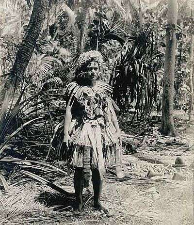
In 1894, Count Rudolph Festetics de Tolna, his wife Eila (née Haggin) and her daughter Blanche Haggin visited Funafuti aboard the yacht Le Tolna.[25][26] The Count spent several days photographing men and woman of Funafuti.[27]
The boreholes on Funafuti at the site now called Darwin's Drill,[28] are the result of drilling conducted by the Royal Society of London for the purpose of investigating whether traces of shallow water organisms could be found at depth in the coral, as a test of Charles Darwin's theory of coral atoll formation. Drilling occurred in 1896, 1897 and 1898.[29] Professor Edgeworth David of the University of Sydney was a member of the 1896 expedition and was the leader of the 1897 expedition.[30][31] Photographers on the expeditions recorded people, communities and scenes at Funafuti.[32]
Harry Clifford Fassett, captain's clerk and photographer, recorded people, communities and scenes at Funafuti during a visit of USFC Albatross when the US Fish Commission was investigating the formation of coral reefs on Pacific atolls.[33]
The population of Funafuti from 1860 to 1900 is estimated to be between 280[34] and 300 people.[35]
Funafuti Post Office opened around 1911.[36]
Cyclones of 1883 & 1972
George Westbrook, a trader on Funafuti, recorded a tropical cyclone that struck Funafuti in 1883. At the time of the cyclone struck he was the sole inhabitant of Fongafale as Tema, the Samoan missionary, had taken everyone else to Funafala to work on erecting a church. The buildings on Fongafale were destroyed, including the church and the trade stores of George Westbrook and Alfred Restieaux. Little damage had occurred at Funafala and the people returned to rebuild at Fongafale.[37]

In 1972 Funafuti was in the path of Cyclone Bebe during the 1972–73 South Pacific cyclone season. Tropical Cyclone Bebe was a pre-season tropical cyclone that impacted the Gilbert, Ellice Islands, and Fiji island groups.[38] First spotted on 20 October, the system intensified and grew in size through 22 October. At about 4 p.m. on Saturday 21st sea water was bubbling through the coral on the airfield with the water reaching a height of about 5 feet (1.5 m) high. Cyclone Bebe continued through Sunday 22 October. The Ellice Islands Colony's ship Moanaraoi was in the lagoon and survived, however 3 tuna boats were wrecked. Waves broke over the atoll. Five people died; two adults and a 3-month-old child were swept away by waves, and two sailors from the tuna boats were drowned.[39] Cyclone Bebe knocked down 90% of the houses and trees. The storm surge created a wall of coral rubble along the ocean side of Fongafale and Funafala that was about 10 miles (16 km) long, and about 10 feet (3.0 m) to 20 feet (6.1 m) thick at the bottom.[39][40] The cyclone contaminated sources of drinking water as a result of the system's storm surge that flooded or destroyed the sources of fresh water.
Educational institutions
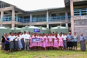
There are two junior schools, the Seventh Day Adventist Primary School and Nauti Primary School, which has a register of more than 900 pupils and is the largest primary school in Tuvalu (45 percent of the total primary school enrolment).[41] The Church of Tuvalu operates Fetuvalu Secondary School.[42][43] The University of the South Pacific (USP) Extension Centre on Funafuti operates the Augmented Foundation Programme for sixth form students who pass their Pacific Secondary School Certificate (PSSC) so that the students can enter tertiary education programmes outside of Tuvalu. The Tuvalu Maritime Training Institute (TMTI) is located on Amatuku motu (islet).
Transportation
Funafuti International Airport is located on Fongafale. Flights are only available twice a week to Suva, Fiji, on Pacific Sun, the regional carrier of Fiji Airways, Fiji's national airline. Pacific Sun flies ATR 42-500 42-seat turboprops between Suva and Funafuti. The airport code for Funafuti is FUN.
There are port facilities on Fongafale. There are two passenger/cargo ships, Nivaga III and Manu Folau, which provide round trip visits to the outer islands every three or four weeks and which also travel between Suva, Fiji[44] and Funafuti 3 to 4 times a year. In 2015 the Nivaga III was donated by the government of Japan; it replaced the Nivaga II, which had serviced Tuvalu from 1989.[45]
Constituency
Funafuti is one of the eight constituencies in Tuvalu, and elects two Members of Parliament. Following the 2015 general election, its current representatives are Kausea Natano and Kamuta Latasi.[46][47] Both were successfully re-elected incumbents.
2015 election results
| Party | Candidate | Votes | % | |
|---|---|---|---|---|
| Non-partisan | Kausea Natano |
423 | 38 | |
| Non-partisan | Sir Kamuta Latasi |
372 | 33 | |
| Non-partisan | Kalepou Tili | 125 | 11 | |
| Non-partisan | Pugameau Naseli Kaituumana | 206 | 18 | |
Prominent local people
- Sir Toaripi Lauti, GCMG PC (28 November 1928 – 25 May 2014) 1st Chief Minister of the Ellice Islands from 2 October 1975 – 1 October 1978; 1st Prime Minister of Tuvalu from 1 October 1978 – 8 September 1981; 3rd Governor General of Tuvalu from 1 October 1990 – 1 December 1993.
- Sir Kamuta Latasi, KCMG OBE PC MP (born 1936) 4th Prime Minister of Tuvalu from 1993 until 1996; Speaker of the Parliament of Tuvalu from 2006 to September 2010 and again from December 2010 to March 2014.
See also
External sources
- Hedley, Charles (1896). "General account of the Atoll of Funafuti" (PDF). Australian Museum Memoir. 3 (2): 1–72.
- (in English) Kench, Thompson, Ford, Ogawa and McLean (2015). "GSA DATA REPOSITORY 2015184 (Changes in planform characteristics of 29 islands located on Funafuti's atoll rim)" (PDF). The Geological Society of America. Retrieved 22 January 2017.
- Lambert, Sylvester M. "Young woman, member of the O'Brien family, Funafuti, Tuvalu". Special Collections & Archives, UC San Diego. Retrieved 18 November 2017.
References
- 1 2 Map of Funafuti. Tuvaluislands.com.
- ↑ Lal, Andrick. South Pacific Sea Level & Climate Monitoring Project - Funafuti atoll (PDF). SPC Applied Geoscience and Technology Division (SOPAC Division of SPC). Archived from the original (PDF) on 3 February 2014. Retrieved 31 January 2014.
- 1 2 "Population of communities in Tuvalu". Thomas Brinkhoff. 11 April 2012. Retrieved 20 March 2016.
- ↑ Coates, A. (1970). Western Pacific Islands. H.M.S.O. p. 349.
- ↑ "Funafuti Strategic Plan 2011-2015" (PDF). Funafuti Falekaupule. February 2011. Retrieved 26 April 2015.
- ↑ "Pacific Aviation Investment Program (PAIP) Environmental Management Plan - Funafuti International Airport(FUN) and Road Interim Working Document" (PDF). AECOM. 13 November 2013. Retrieved 18 March 2016.
- ↑ Endou, Shuuichi (18 May 2011). "Tuvalu Games 2011". Tuvalu-News.TV. Retrieved 31 October 2012.
- ↑ Admiralty Nautical Chart 2983 Tuvalu – Funafuti atoll. United Kingdom Hydrographic Office (UKHO).
- ↑ ftp://rock.geosociety.org/pub/reposit/2001/2001075.pdf
- ↑ "Klimatafel von Funafuti / Tuvalu (Ellice-Inseln)" (PDF). Baseline climate means (1961-1990) from stations all over the world (in German). Deutscher Wetterdienst. Retrieved 22 November 2016.
- ↑ Talakatoa O'Brien (1983). Tuvalu: A History, Chapter 1, Genesis. Institute of Pacific Studies, University of the South Pacific and Government of Tuvalu.
- ↑ Kennedy, Donald G. (1929). "Field Notes on the Culture of Vaitupu, Ellice Islands". Journal of the Polynesian Society. 38: 2–5.
- ↑ Hedley, Charles (1896). General account of the Atoll of Funafuti (PDF). Australian Museum Memoir 3(2): 1–72.
- ↑ De Peyster, J. Watts 1821-1907. Military (1776-'79) transactions of Major, afterwards Colonel, 8th or King's foot, Arent Schuyler de Peyster (with details of the discovery of the Ellice and de Peyster Islands in the Pacific Ocean, in May, 1819). Reproduction of original in: Bibliotheque nationale du Quebec. ISBN 0665040512.
- ↑ "The De Peysters". Retrieved 14 August 2017.
- ↑ Laumua Kofe, Palagi and Pastors, Tuvalu: A History, Ch. 15, Institute of Pacific Studies, University of the South Pacific and Government of Tuvalu, 1983
- ↑ Tyler, David B. – 1968 The Wilkes Expedition. The First United States Exploring Expedition (1838–42). Philadelphia: American Philosophical Society
- ↑ "A Brief History of Tuvalu: Christianity and European Traders". Tuvaluislands.com. Retrieved 15 September 2013.
- ↑ Lambert, Sylvester M. "Young woman, member of the O'Brien family, Funafuti, Tuvalu". Special Collections & Archives, UC San Diego. Retrieved 25 January 2017.
- ↑ Resture, Jane. "Alfred Restieaux Manuscripts – Part 2". Jane Resture. Retrieved 23 March 2013.
- ↑ Munro, Doug (1980). "Tom De Wolf's Pacific Venture: The Life History of a Commercial Enterprise in Samoa". Retrieved 23 March 2013.
- ↑ Andrew, Thomas (1886). "Washing Hole Funafuti. From the album: Views in the Pacific Islands". Collection of Museum of New Zealand (Te Papa). Retrieved 10 April 2014.
- ↑ Resture, Jane. "TUVALU HISTORY – 'The Davis Diaries' (H.M.S. Royalist, 1892 visit to Ellice Islands under Captain Davis)". Retrieved 20 September 2011.
- ↑ Hedley, Charles (1896). "General account of the Atoll of Funafuti" (PDF). Australian Museum Memoir. 3 (2): 1–72.
- ↑ Festetics De Tolna, Comte Rodolphe, Chez les cannibales: huit ans de croisière dans l'océan Pacifique à bord du, Paris: Plon-Nourrit, 1903
- ↑ "The Aristocrat and His Cannibals" Count Festetics von Tolna's travels in Oceania, 1893–1896. musée du quai Branly. 2007.
- ↑ "Néprajzi Múzeum Könyvtára". The library of the Ethnographic Museum of Hungary. Retrieved 20 September 2011.
- ↑ Lal, Andrick. South Pacific Sea Level & Climate Monitoring Project – Funafuti atoll (PDF). SPC Applied Geoscience and Technology Division (SOPAC Division of SPC). pp. 35 & 40. Archived from the original (PDF) on 3 February 2014.
- ↑ "TO THE EDITOR OF THE HERALD". The Sydney Morning Herald. National Library of Australia. 11 September 1934. p. 6. Retrieved 20 June 2012.
- ↑ Branagan, D.F. (2005): T.W. Edgeworth David: A Life: Geologist, Adventurer and "Knight in the Old Brown Hat", National Library of Australia, Canberra, pp. 85–105. ISBN 0 642 10791 2
- ↑ David, Mrs Edgeworth, Funafuti or Three Months On A Coral Atoll: an unscientific account of a scientific expedition, London: John Murray, 1899
- ↑ Photography Collection, University of Sydney Library
- ↑ "National Archives & Records Administration". Records of the United States Fish and Wildlife Service, U.S. Retrieved 20 Sep 2011.
- ↑ Newton, W. F. (1967). "The Early Population of the Ellice Islands". Journal of the Polynesian Society. 76 (2): 197–204.
- ↑ Bedford, Richard; Macdonald, Barrie; Monro, Doug (1980). "Population Estimates for Kiribati and Tuvalu". Journal of the Polynesian Society. 89 (1): 199.
- ↑ Premier Postal History. "Post Office List". Premier Postal Auctions. Retrieved 5 July 2013.
- ↑ Resture, Jane. Hurricane 1883. Tuvalu and the Hurricanes: ‘Gods Who Die’ by Julian Dana as told by George Westbrook.
- ↑ Bureau of Meteorology (1975) Tropical Cyclones in the Northern Australian Regions 1971–1972 Australian Government Publishing Service
- 1 2 Resture, Jane (5 October 2009). Hurricane Bebe 1972. Tuvalu and the Hurricanes: 'The Hurricane in Funafuti, Tuvalu' by Pasefika Falani (Pacific Frank).
- ↑ Warne, Kennedy (13 February 2015). "Will Pacific Island Nations Disappear as Seas Rise? Maybe Not – Reef islands can grow and change shape as sediments shift, studies show". National Geographic. Retrieved 14 February 2015.
- ↑ 2012 Population & Housing Census Preliminary Analytical Report (April 2013). "Tuvalu: Millennium Development Goal Acceleration Framework – Improving Quality of Education" (PDF). Ministry of Education and Sports, and Ministry of Finance and Economic Development from the Government of Tuvalu; and the United Nations System in the Pacific Islands. Retrieved 13 October 2013.
- ↑ "Fetuvalu High School (Funafuti)". Retrieved 20 November 2012.
- ↑ Holowaty Krales, Amelia (10 March 2011). "TB Workshop at Fetu Valu Secondary School". Retrieved 20 November 2012.
- ↑ Fiji shipping agent, Williams & Gosling.
- ↑ Moceituba, Atasa (3 February 2016). "Brand-new vessel for Tuvalu". The Fiji Times Online. Retrieved 17 March 2016.
- ↑ "Election looks set to return Sopoaga as Tuvalu's PM". Radio New Zealand. 2 April 2015. Retrieved 2 April 2015.
- ↑ "Tuvalu National Election 2015 Results (Funafuti)". Fenui News. 1 April 2015. Retrieved 1 April 2015.
| Islands |  | |
|---|---|---|
| Atolls | ||
| Islets of Funafuti | ||
| Islets of Nanumea | ||
| Islets of Nui | ||
| Islets of Nukufetau | ||
| Islets of Vaitupu | ||