Cannelburg, Indiana
| Cannelburg, Indiana | |
|---|---|
| Town | |
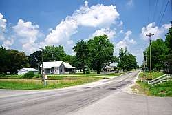 Main Street | |
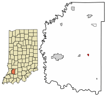 Location of Cannelburg in Daviess County, Indiana. | |
| Coordinates: 38°40′9″N 86°59′57″W / 38.66917°N 86.99917°WCoordinates: 38°40′9″N 86°59′57″W / 38.66917°N 86.99917°W | |
| Country | United States |
| State | Indiana |
| County | Daviess |
| Township | Barr |
| Area[1] | |
| • Total | 0.20 sq mi (0.51 km2) |
| • Land | 0.20 sq mi (0.51 km2) |
| • Water | 0.00 sq mi (0.00 km2) |
| Elevation | 525 ft (160 m) |
| Population (2010)[2] | |
| • Total | 135 |
| • Estimate (2016)[3] | 156 |
| • Density | 795.92/sq mi (307.71/km2) |
| Time zone | UTC-5 (EST) |
| • Summer (DST) | UTC-5 (EST) |
| ZIP code | 47519 |
| Area code(s) | 812 |
| FIPS code | 18-10090[4] |
| GNIS feature ID | 0449631[5] |
Cannelburg is a town in Barr Township, Daviess County, Indiana, United States. The population was 135 at the 2010 census.
History
Cannelburg was platted in 1872, and named for the cannel coal mined in the area.[6]
Geography
Cannelburg is located at 38°40′9″N 86°59′57″W / 38.66917°N 86.99917°W (38.669065, -86.999070).[7] The town is concentrated along Main Street, which runs northward perpendicular to U.S. Route 50/U.S. Route 150. Loogootee lies to the east, and Montgomery lies to the west.
According to the 2010 census, Cannelburg has a total area of 0.19 square miles (0.49 km2), all land.[8]
Demographics
| Historical population | |||
|---|---|---|---|
| Census | Pop. | %± | |
| 1880 | 159 | — | |
| 1890 | 276 | 73.6% | |
| 1900 | 280 | 1.4% | |
| 1910 | 300 | 7.1% | |
| 1920 | 224 | −25.3% | |
| 1930 | 132 | −41.1% | |
| 1940 | 145 | 9.8% | |
| 1950 | 128 | −11.7% | |
| 1960 | 124 | −3.1% | |
| 1970 | 149 | 20.2% | |
| 1980 | 152 | 2.0% | |
| 1990 | 97 | −36.2% | |
| 2000 | 140 | 44.3% | |
| 2010 | 135 | −3.6% | |
| Est. 2016 | 156 | [3] | 15.6% |
| U.S. Decennial Census[9] | |||
2010 census
As of the census[2] of 2010, there were 135 people, 57 households, and 41 families residing in the town. The population density was 710.5 inhabitants per square mile (274.3/km2). There were 58 housing units at an average density of 305.3 per square mile (117.9/km2). The racial makeup of the town was 99.3% White and 0.7% from two or more races. Hispanic or Latino of any race were 0.7% of the population.
There were 57 households of which 29.8% had children under the age of 18 living with them, 59.6% were married couples living together, 7.0% had a female householder with no husband present, 5.3% had a male householder with no wife present, and 28.1% were non-families. 26.3% of all households were made up of individuals and 14% had someone living alone who was 65 years of age or older. The average household size was 2.37 and the average family size was 2.85.
The median age in the town was 44.2 years. 21.5% of residents were under the age of 18; 10.4% were between the ages of 18 and 24; 20% were from 25 to 44; 28.1% were from 45 to 64; and 20% were 65 years of age or older. The gender makeup of the town was 53.3% male and 46.7% female.
2000 census
As of the census[4] of 2000, there were 140 people, 51 households, and 42 families residing in the town. The population density was 747.3 people per square mile (284.5/km²). There were 54 housing units at an average density of 288.3 per square mile (109.7/km²). The racial makeup of the town was 100.00% White.
There were 51 households out of which 43.1% had children under the age of 18 living with them, 64.7% were married couples living together, 11.8% had a female householder with no husband present, and 17.6% were non-families. 17.6% of all households were made up of individuals and 5.9% had someone living alone who was 65 years of age or older. The average household size was 2.75 and the average family size was 3.07.
In the town, the population was spread out with 33.6% under the age of 18, 7.1% from 18 to 24, 29.3% from 25 to 44, 19.3% from 45 to 64, and 10.7% who were 65 years of age or older. The median age was 32 years. For every 100 females, there were 94.4 males. For every 100 females age 18 and over, there were 102.2 males.
The median income for a household in the town was $37,917, and the median income for a family was $37,917. Males had a median income of $32,083 versus $16,458 for females. The per capita income for the town was $12,674. There were 20.9% of families and 14.9% of the population living below the poverty line, including 11.8% of under eighteens and none of those over 64.
References
- ↑ "2016 U.S. Gazetteer Files". United States Census Bureau. Retrieved Jul 28, 2017.
- 1 2 "American FactFinder". United States Census Bureau. Retrieved 2012-12-11.
- 1 2 "Population and Housing Unit Estimates". Retrieved June 9, 2017.
- 1 2 "American FactFinder". United States Census Bureau. Archived from the original on 2013-09-11. Retrieved 2008-01-31.
- ↑ "US Board on Geographic Names". United States Geological Survey. 2007-10-25. Retrieved 2008-01-31.
- ↑ History of Knox and Daviess County, Indiana: From the Earliest Time to the Present; with Biographical Sketches, Reminiscences, Notes, Etc. ; Together with an Extended History of the Colonial Days of Vincennes, and Its Progress Down to the Formation of the State Government. Goodspeed. 1886. p. 705.
- ↑ "US Gazetteer files: 2010, 2000, and 1990". United States Census Bureau. 2011-02-12. Retrieved 2011-04-23.
- ↑ "G001 - Geographic Identifiers - 2010 Census Summary File 1". United States Census Bureau. Retrieved 2015-07-13.
- ↑ "Census of Population and Housing". Census.gov. Archived from the original on May 12, 2015. Retrieved June 4, 2015.
External links

Municipalities and communities of Daviess County, Indiana, United States | ||
|---|---|---|
| City | ||
| Towns | ||
| Townships | ||
| CDP | ||
| Other unincorporated communities | ||