Candaba Viaduct
| Candaba Viaduct | |
|---|---|
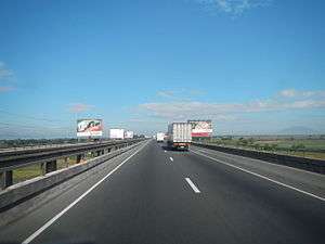 Northbound Lane of the Viaduct | |
| Carries |
6 lanes of |
| Crosses |
Candaba Swamps Pampanga River |
| Locale |
Apalit, Pampanga (North) Pulilan, Bulacan (South) |
| Official name | Candaba Viaduct |
| Other name(s) | Pulilan–Apalit Bridge (STA 46+932 - 52+118) |
| Maintained by | Manila North Tollways Corporation (MNTC) |
| Characteristics | |
| Design | Viaduct |
| Material | Concrete, asphalt |
| Total length | 5,000 m (16,000 ft) |
| Width | 12 m (39 ft) per direction |
| Height | 15 m (49 ft 3 in) |
| History | |
| Designer | Aas-Jakobsen[1] |
| Constructed by | Philippine National Construction Corporation[2] |
| Construction start | 1974 |
| Construction end | 1976 |
| Opened | 1977-present |
| Statistics | |
| Toll | Yes (part of toll road) |
The Candaba Viaduct (also known as Pulilan–Apalit Bridge) is a 5 kilometres (3 mi) bridge in the North Luzon Expressway (NLEX). Consisting of four lanes (two northbound and two southbound), it is the longest bridge in the Philippines.[3] The viaduct was designed by Aas-Jakobsen[1] and built by Construction Development Corporation of the Philippines (CDCP, later renamed to Philippine National Construction Corporation) as part of construction of the whole NLEX.[2]
Built in 1976, the bridge and the whole stretch of NLEX were constructed as a component project of the International Bank for Reconstruction and Development through the direction Ministry of Public Highways.[2] The project was completed in 1977 and through Presidential Decree 1113, then President Ferdinand Marcos granted CDCP the franchise to maintain and operate the NLEX including the Candaba Viaduct.[4] On February 10, 2005, the operations and maintenance of the whole of NLEX were transferred to the Manila North Tollways Corporation.[5]
Overlooking Mount Arayat, the viaduct is raised over Candaba Swamp, which keeps the highway open to traffic, even when the swamp gets flooded during the rainy or monsoon season.[6] Lighting, emergency callboxes and CCTVs along the viaduct are powered by solar panels due to the problem of installing power lines within the viaduct.[7]
In February 2017, it was announced that Candaba Viaduct will be expanded and will be having new expressway lanes on both sides of the bridge.[8]
Route description
The Candaba Viaduct passes over Candaba Swamp and adjacent Pampanga River and connects the provinces of Pampanga and Bulacan,[3] hence its alternative name. Most of its portions are lined with billboards, ricefields, and some trees. The Hermosa-Duhat-Balintawak transmission line of National Grid Corporation of the Philippines (NGCP) also utilize a significant portion of the viaduct since March 2011 as the densely populated areas hinder acquisition of dedicated right of way.
The viaduct starts at Barangay Dulong Malabon in Pulilan where there are a few houses located under it and after a few meters, it enters the municipality of Calumpit. It enters Pampanga (Apalit) after passing an area with palm trees, continues a straight route, and passes through Pampanga River, where its parish church is visible from the road. A footbridge is located on its southbound lane. The bridge ends after crossing Pampanga River.
See also
References
- 1 2 "Candaba Viaduct". Structurae. Retrieved March 2, 2017.
- 1 2 3 "PNCC PROJECTS". Philippine National Construction Corporation. Retrieved March 2, 2017.
- 1 2 "Bridges for Development". BusinessWorld. August 30, 2016. Retrieved March 2, 2017.
- ↑ "P.D. No. 1113". www.lawphil.net. Retrieved March 2, 2017.
- ↑ "PNCC::dot::Ph : OUR BUSINESS". www.pncc.ph. Philippine National Construction Corporation. Retrieved March 2, 2017.
- ↑ "How to prepare for our future climate". World Economic Forum. May 20, 2014. Retrieved March 2, 2017.
- ↑ Remo, Amy R. (August 9, 2011). "Solar-powered lamp posts eyed for NLEx". business.inquirer.net. Retrieved March 3, 2017.
- ↑ "P2.6b Nlex expansion in the offing". Manila Standard. February 23, 2017. Retrieved March 3, 2017.
External links
![]()