Grenville-sur-la-Rouge, Quebec
| Grenville-sur-la-Rouge | ||
|---|---|---|
| Municipality | ||
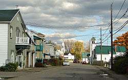 Calumet's quiet main street | ||
| ||
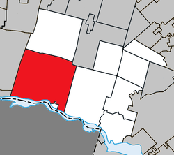 Location within Argenteuil RCM. | ||
 Grenville-sur-la-Rouge Location in central Quebec. | ||
| Coordinates: 45°39′N 74°38′W / 45.650°N 74.633°WCoordinates: 45°39′N 74°38′W / 45.650°N 74.633°W[1] | ||
| Country |
| |
| Province |
| |
| Region | Laurentides | |
| RCM | Argenteuil | |
| Constituted | April 24, 2002 | |
| Boroughs | ||
| Government[2] | ||
| • Mayor | Tom Arnold | |
| • Federal riding | Argenteuil—La Petite-Nation | |
| • Prov. riding | Argenteuil | |
| Area[2][3] | ||
| • Total | 329.40 km2 (127.18 sq mi) | |
| • Land | 315.85 km2 (121.95 sq mi) | |
| Population (2011)[3] | ||
| • Total | 2,746 | |
| • Density | 8.7/km2 (23/sq mi) | |
| • Pop 2006-2011 |
| |
| • Dwellings | 1,899 | |
| Time zone | UTC−5 (EST) | |
| • Summer (DST) | UTC−4 (EDT) | |
| Postal code(s) | J0V 1J0 | |
| Area code(s) | 819 | |
| Highways |
| |
| Website |
www.grenville surlarouge.ca | |
.svg.png)
Grenville-sur-la-Rouge is a municipality in the Argenteuil Regional County Municipality in the Laurentides region of Quebec, Canada. It is a predominantly Francophone community situated along the southern border of Quebec between Montreal and Ottawa.
Grenville-sur-la-Rouge covers a rectangular area along the shore of the Ottawa River and extends northward into the foothills of the Laurentian Mountains. The neighbouring village of Grenville is located on the Ottawa River.
Most of the population of just over 2,700 live in a rural setting; the villages of Calumet and Pointe-au-Chêne comprise under 1,000 residents in total.
History
Although the area has been settled for over 200 years, Grenville-sur-la-Rouge is a relatively new creation. It was formed in 2002 (as an ordinary municipality) by the merger of the village municipality of Calumet with the township municipality of Grenville;[4] the latter is not to be confused with the neighbouring and still-independent village municipality of Grenville. Each of the two components, Calumet and Grenville, acquired the status of boroughs within the new municipality. The territory of Grenville-sur-la-Rouge includes several smaller neighbourhoods and communities, including Avoca, Bell Falls, Grenville Bay, Kilmar, Marelan, and Pointe-au-Chêne.
The name "Grenville" comes from William Wyndham Grenville, a British statesman who served briefly as British prime minister (1806–1807). While Canada was still under British rule, a canal was built by the military to bypass a series of rapids in the Ottawa River. The canal and the settlement that arose in the region were named in Lord Grenville's honour.
The name "Rouge" derives from the municipality's location on the Rouge River, which runs from north to south roughly through the centre of the municipality. In English, Grenville-sur-la-Rouge means "Grenville-on-the-Rouge".
Economy
Similar to several other rural communities that make up the county of Argenteuil, businesses located in Grenville-sur-la-Rouge are predominantly resource-based. Many of the properties along the primary and secondary roads are established farms operated by third and fourth generation families. Forests cover a significant percentage of region and supports a limited amount of logging for regional pulp and paper mills, such as the Fraser Papers mill in Thurso, Quebec. A recently revitalized magnesite mine in Kilmar provides ore for Harbison-Walker's refractory plant in Marelan. Prior to 1980, this mine ran a private railway between Kilmar and Marlean known as the Dominion Timber and Minerals Railway that has now been all but destroyed.
Tourism is an important part of the local economy, with several whitewater adventure companies being established along the Rouge River. First commercialized in the late 1970s, the Rouge River has become Quebec's most popular whitewater rafting location and is considered one of the best in North America. Local owners have also turned century-old homes into Bed & Breakfasts, which are especially popular in the fall.
The 2001 Statistics Canada census reports that the majority of Grenville-sur-la-Rouge's residents earn income from non-resource based sectors.
Transportation
Route 148 and Route 344 are east-west highways that traverse the southern region of the municipality. Autoroute 50, an east-west highway, is also in the southern region with three interchanges in Grenville-sur-la-Rouge. Route 344 briefly passes through the Village of Grenville where one can cross over the Long-Sault Bridge to Hawkesbury, Ontario. The Long-Sault Bridge is the only bridge that crosses the Ottawa River between Ottawa and Montreal. The primary north-south access roads are the Rouge River Road, the Scotch Road, and Avoca Road. These secondary roads provide access to the communities of Avoca, Kilmar and Bell Falls.
Government
Local government comprises a mayor and councillors. The current mayor is Tom Arnold.
Demographics
- Population:
- Population in 2011: 2746
- Population in 2006: 2721
- Population in 2001: 2663 (adjusted for boundary changes)
- Private dwellings (occupied by usual residents): 1248
- Languages:
- English as first language: 34%
- French as first language: 64%
- English and French as first language: 0.5%
- Other as first language: 1.5%
The following statistics are derived from the pre-amalgamation data collected by Statistics Canada in its 2001 census. Data reported is the combined data of the Municipality of Grenville and the Village of Calumet .
- Population density: 8.5 people per square km
- Language(s) First Learned / Still Understood:
- French 56.4%
- English 39.1%
- Both English/French 2.4%
- Other 2.1%
- Religious affiliation
- Catholic 62.9%
- Protestant 26.2%
- Christian Orthodox 0.7%
- Other religions 0.4%
- No religious affiliation 9.7%
- Experienced labour force
- Agriculture and other resource-based industries 5.9%
- Manufacturing and construction industries 37.0%
- Wholesale and retail trade 14.7%
- Finance and real estate 5.5%
- Health and education 9.7%
- Business services 10.9%
- Other services 16.4%
A.J. Casson
In the late 1960s, Alfred Joseph Casson (1892–1992) of Group of Seven fame, spent some time in what is now known as Grenville-sur-la-Rouge capturing the beautiful scenery on the lower Ottawa Valley. Paul Duval, in his biography of Casson wrote:[5]
| “ | In 1958 Casson retired from Sampson Matthews Limited, which enabled him to devote himself full-time to painting. Although the Ontario countryside had been his main focus, starting in 1966 he turned his attention more seriously to Quebec. Up until this time, his experience there had been limited to a two-week trip to Lac La Pêche in 1950. As Duval writes, "Casson was persuaded at last to paint in Quebec by A.Y. Jackson...Jackson spoke enthusiastically about the painting possibilities around the town of Grenville, a half-French, half-English community where he had stayed as a guest of Munroe Putnam." The Putnams, while in Toronto buying a number of sketches by Casson, invited him to their home to paint with Jackson. Casson made six consecutive summer trips to Grenville, exploring and painting the surrounding countryside, with Jackson showing him the choicest painting places. Duval writes, "Near to Grenville, were Harrington, Avoca and Montebello, all ideal landscape sites offering a rich variety of topography... Altogether he painted at least 150 oil sketches while based at Grenville, more than he had ever done of any one specific place." This fine canvas reflects Casson's deep regard for this beautiful countryside. | ” |
Examples of Casson's painting from the region include:
Education
The Commission scolaire de la Rivière-du-Nord operates French-language public schools.[6]
- École polyvalente Lavigne in Lachute
The Sir Wilfrid Laurier School Board operates English-language public schools:
See also
References
- ↑ Reference number 373691 of the Commission de toponymie du Québec (in French)
- 1 2 Geographic code 76052 in the official Répertoire des municipalités (in French)
- 1 2 "(Code 2476052) Census Profile". 2011 census. Statistics Canada. 2012.
- ↑ http://www.stat.gouv.qc.ca/publications/referenc/pdf/modavr02.pdf%5Bpermanent+dead+link%5D
- ↑ http://www.heffel.com/New/Auction/Lots.aspx?Search=0&ID=0&Page=8
- ↑ "Trouver une école ou un centre." Commission scolaire de la Rivière-du-Nord. Retrieved on September 24, 2017. For attendance boundary information, click "Par bassin d'école"
- ↑ "About Us." Grenville Elementary School. Retrieved on September 17, 2017.
- ↑ "LAURENTIAN ELEMENTARY ZONE." Sir Wilfrid Laurier School Board. Retrieved on September 16, 2017.
- ↑ "LAURENTIAN REGIONAL HS ZONE." Sir Wilfrid Laurier School Board. Retrieved on September 4, 2017.
External links
| Wikimedia Commons has media related to Grenville-sur-la-Rouge. |
Adjacent Municipal Subdivisions | |
|---|---|
| Towns | |
|---|---|
| Municipalities | |
| Townships | |
| Villages | |
| |