East Hawkesbury
| East Hawkesbury | |
|---|---|
| Township (lower-tier) | |
|
Township of East Hawkesbury Canton de Hawkesbury Est | |
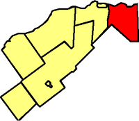 Location within Prescott and Russell | |
 East Hawkesbury Location within Ontario | |
| Coordinates: 45°31′N 74°28′W / 45.517°N 74.467°WCoordinates: 45°31′N 74°28′W / 45.517°N 74.467°W | |
| Country |
|
| Province |
|
| County | Prescott and Russell |
| Government | |
| • Mayor | Robert Kirby |
| • Federal riding | Glengarry—Prescott—Russell |
| • Prov. riding | Glengarry—Prescott—Russell |
| Area[1] | |
| • Land | 235.18 km2 (90.80 sq mi) |
| Population (2016)[2] | |
| • Total | 3,296 |
| • Density | 14.0/km2 (36/sq mi) |
| Time zone | UTC-5 (EST) |
| • Summer (DST) | UTC-4 (EDT) |
| Postal Code FSA | K0B |
| Area code(s) | 613 |
| Website | www.easthawkesbury.ca |
East Hawkesbury is a township in eastern Ontario, Canada, in the United Counties of Prescott and Russell. It is on the Ottawa River. Its eastern boundary is the border with the province of Quebec.
Communities
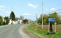
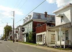
The township comprises the villages of Chute-à-Blondeau, Sainte-Anne-de-Prescott and Saint-Eugène. The township administrative offices are located in St. Eugene.[3]
 Chute-a-Blondeau |
 St. Eugene |
History
During World War II the Royal Canadian Air Force built and operated No. 13 Elementary Flying Training School as part of the British Commonwealth Air Training Plan [4] on a site 2 km south of St. Eugene. The school opened on 28 October 1940 and closed on 19 June 1945.
The airfield was located at 45°29′17″N 074°28′17″W / 45.48806°N 74.47139°W.
Demographics
| Canada census – East Hawkesbury community profile | |||
|---|---|---|---|
| 2016 | 2011 | 2006 | |
| Population: | 3,296 (-1.2% from 2011) | 3335 (-1.0% from 2006) | 3368 (-1.4% from 2001) |
| Land area: | 235.18 km2 (90.80 sq mi) | 235.09 km2 (90.77 sq mi) | |
| Population density: | 14.2/km2 (37/sq mi) | 14.3/km2 (37/sq mi) | |
| Median age: | 43.1 (M: 43.8, F: 42.3) | ||
| Total private dwellings: | 1,482 | 1386 | 1428 |
| Median household income: | $50,230 | ||
| References: 2016[2] 2011[1] 2006[5] earlier[6] | |||
See also
References
- 1 2 "2011 Community Profiles". Canada 2011 Census. Statistics Canada. July 5, 2013. Retrieved 2012-02-27.
- 1 2 "2016 Community Profiles". Canada 2016 Census. Statistics Canada. February 21, 2017.
- ↑ "Mayor's Welcome :: East Hawkesbury Township". easthawkesbury.ca. Retrieved 2018-04-19.
- ↑ Hatch, F. J. (1983). The Aerodrome of Democracy: Canada and the British Commonwealth Air Training Plan, 1939-1945. Ottawa: Directorate of History, Department of National Defence. ISBN 0660114437.
- ↑ "2006 Community Profiles". Canada 2006 Census. Statistics Canada. March 30, 2011. Retrieved 2012-02-27.
- ↑ "2001 Community Profiles". Canada 2001 Census. Statistics Canada. February 17, 2012.
External links
| Wikimedia Commons has media related to East Hawkesbury, Ontario. |
Places adjacent to East Hawkesbury | |
|---|---|
This article is issued from
Wikipedia.
The text is licensed under Creative Commons - Attribution - Sharealike.
Additional terms may apply for the media files.