Calk, Kentucky
| Calk | |
|---|---|
| Unincorporated community | |
 Calk Location within the state of Kentucky  Calk Calk (the US) | |
| Coordinates: 38°01′47″N 83°57′51″W / 38.02972°N 83.96417°WCoordinates: 38°01′47″N 83°57′51″W / 38.02972°N 83.96417°W | |
| Country | United States |
| State | Kentucky |
| County | Montgomery |
| Elevation | 981 ft (299 m) |
| Time zone | UTC-5 (Eastern (EST)) |
| • Summer (DST) | UTC-4 (EDT) |
| GNIS feature ID | 2491587[1] |
Calk is an unincorporated community within Montgomery County, Kentucky, United States.
References
Municipalities and communities of Montgomery County, Kentucky, United States | ||
|---|---|---|
| Cities | 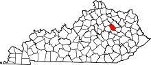 | |
| Unincorporated community | ||
This article is issued from
Wikipedia.
The text is licensed under Creative Commons - Attribution - Sharealike.
Additional terms may apply for the media files.