California State Route 55
| ||||
|---|---|---|---|---|
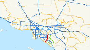 State Route 55 highlighted in red | ||||
| Route information | ||||
| Defined by Streets and Highways Code § 355 | ||||
| Maintained by Caltrans | ||||
| Length | 17.807 mi[1] (28.658 km) | |||
| Existed | 1964 – present | |||
| Major junctions | ||||
| South end | Via Lido in Newport Beach | |||
| ||||
| North end |
| |||
| Location | ||||
| Counties | Orange | |||
| Highway system | ||||
| ||||

State Route 55 (SR 55) is an 18-mile (30-km) long north–south highway in the U.S. state of California. The portion of the route built to freeway standards is known as the Costa Mesa Freeway (formerly the Newport Freeway). SR 55 runs between Via Lido[2] south of Pacific Coast Highway (SR 1) in Newport Beach and the Riverside Freeway (SR 91) in Anaheim to the north, intersecting other major Orange County freeways such as SR 22, SR 73, and Interstate 405 (I-405). The freeway passes through suburban Orange County.
SR 55 was first added to the state highway system in 1931, known as part of Legislative Route 43, and was routed on surface streets. It was renumbered SR 55 in 1959, and the construction of the freeway portion began in the 1960s and continued until 1992. Due to congestion, several alternatives are being discussed to expand the freeway portion past its current end in Newport Beach. SR 55 received the first carpool lane in Orange County in 1985, and the first direct carpool ramp in 1995.
Route description
Starting at Via Lido on Newport Boulevard in Newport Beach, 0.3 miles (0.48 km) south of SR 1, SR 55 (Newport Boulevard) is a four-lane expressway for approximately 0.75 miles (1.21 km) to its intersection with 17th Street in Costa Mesa. It then follows a traditional street routing through a retail and commercial section of Costa Mesa until its intersection with 19th Street. The segment on Newport Boulevard includes a limited-access interchange at SR 1. Following the 19th Street intersection, SR 55 becomes an eight-lane below-grade freeway that bisects the northbound and southbound lanes of Newport Boulevard until the Mesa Drive undercrossing.[3]
North of Fair Drive, SR 55 is an at-grade or above-grade freeway, with the exception of a 1 mile (1.6 km) stretch between the 1st Street/4th Street exit and the 17th Street exit in Santa Ana, which is below-grade. SR 55 intersects SR 73 and I-405 next to John Wayne Airport. The freeway continues north into Santa Ana and Tustin, where there is an interchange with I-5. The southbound side of the Costa Mesa Freeway does not have a direct link to northbound I-5.[3]
SR 55 continues north into Orange, where it meets the eastern terminus of SR 22. Following this, the freeway continues almost due north until turning northeast to merge with SR 91 eastbound, and intersecting ramps for SR 91 westbound near the Santa Ana River. After the last exit, Lincoln Avenue and Nohl Ranch Road, there is an entrance to a toll road from the HOV lane called the 91 Express Lanes.[3]
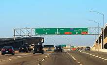
Today, SR 55 is a heavily travelled corridor linking southern Orange County with SR 91, the main corridor between the Inland Empire and the Los Angeles Metropolitan Area, as well as I-5, the main north–south corridor for California. A HOV lane has been built along the entire freeway portion, with some off- and on-ramps, including one for I-5. However, congestion is still very prevalent throughout the day, as is the norm with many Orange County freeways; Route 55 experiences a peak daily traffic volume of 262,000 vehicles and 17,292 trucks.[4][5]
SR 55 is part of the California Freeway and Expressway System,[6] and is part of the National Highway System,[7] a network of highways that are considered essential to the country's economy, defense, and mobility by the Federal Highway Administration.[8] SR 55 from SR 91 to Costa Mesa is known as the Costa Mesa Freeway, as named by Assembly Concurrent Resolution 177, Chapter 86 in 1976.[9]
History
SR 55 was built in 1931 and originally numbered Route 43. It was built from the southern terminus of SR 1 (the Pacific Coast Highway, or "PCH") and continued northbound on roughly the same route it follows today,[10] following Newport Road (today Newport Boulevard) northeast to Tustin, and then Tustin Avenue north to near its current terminus at SR 91.[11] From here, Route 43 continued east on what is now SR 91 towards Riverside. In 1959, the highway was renumbered as Route 55, and its route was shortened from Route 1 to the also-renumbered Route 91.[10] The freeway portion from Chapman Avenue to SR 91 opened on January 18, 1962, at a cost of $4.6 million (equivalent to $28.6 million in 2016[12] ).[13] The segment between SR 73 and Chapman Avenue opened in 1966.[5]
SR 55 was the first freeway in Orange County to receive carpool lanes, opened in October 1985 between I-405 and SR 91. The stretch of SR 55 between Mesa Drive and 19th Street in Costa Mesa was opened in 1992;[5] plans to extend SR 55 freeway south from 19th Street to State Route 1 were never realized[14] due to community opposition, fueling an amendment to the city charter to prevent this extension.[15]
In 1995, the direct carpool lane ramps between I-5 and SR 55 were completed; these were the first in Orange County.[5] The year also saw further widening of SR 55 between SR 22 and McFadden Avenue. Between 1996 and 2002, the fifth lane in both directions was constructed between I-5 and SR 91, funded with a sales tax of half a cent approved by Measure M.[16] In April 2007, the Orange County Transportation Authority approved funds to study the feasibility of extending the Costa Mesa Freeway south to 17th Street via tunnels or flyover ramps.[14] The segment of SR 55 from Finley Street to the Newport Channel bridge was legally authorized to be turned over to the city of Newport Beach in 2009.[17]
In the mid 2000s, Caltrans began adding the city of Anaheim as a control city on State Route 55 North. Signs that mention State Route 55 North would have the newer reflective posting pasted over the button sign or would be replaced with a new one that says "Anaheim/Riverside" to reflect this change.
SR 55 was formerly called the Newport Freeway.[18] In 2010, the stretch between Chapman and Katella avenues in the City of Orange was renamed the Paul Johnson Freeway for longtime local radio television traffic reporter Paul Johnson, who died the same year.[19]
Major intersections
The entire route is in Orange County.
| Location | mi[20] | km | Exit[20] | Destinations | Notes |
|---|---|---|---|---|---|
| Newport Beach | Newport Boulevard south | Continuation beyond Finley Avenue | |||
| 0.00 | 0.00 | Finley Avenue | Southern terminus of SR 55 | ||
| 0.27 | 0.43 | 1 | |||
| Costa Mesa | 1.87 | 3.01 | 2 | Newport Boulevard north, Harbor Boulevard | South end of freeway; northbound exit and southbound entrance |
| 2.77 | 4.46 | 3 | Victoria Street, 22nd Street | ||
| 4.02 | 6.47 | 4 | Del Mar Avenue, Fair Drive | ||
| 4.74 | 7.63 | 5A | Northbound exit and southbound entrance | ||
| 5B | Baker Street | ||||
| 5.99 | 9.64 | 6A | Southbound exit and northbound entrance; I-405 exit 9A | ||
| 6B | Signed as exit 6 northbound; I-405 exit 9A | ||||
| — | HOV access only; southbound exit and northbound entrance | ||||
| — | HOV access only; southbound exit and northbound entrance | ||||
| Santa Ana | 6.99 | 11.25 | 7 | MacArthur Boulevard, Main Street | |
| 7.85 | 12.63 | 8 | Dyer Road | Signed as exits 8A (east) and 8B (west) southbound | |
| 9.44 | 15.19 | 9 | Edinger Avenue | ||
| Tustin | 9.96 | 16.03 | 10A | McFadden Avenue – Tustin | Signed as exit 10 southbound |
| — | HOV access only; northbound exit and southbound entrance | ||||
| 10B | Northbound exit and southbound entrance; I-5 exit 103 southbound, 103A northbound. | ||||
| 10.98 | 17.67 | 11A | I-5 exit 103 southbound, 103B northbound. | ||
| 11B | 4th Street, Irvine Boulevard | ||||
| 11.79 | 18.97 | 12 | 17th Street – Tustin, Santa Ana | Signed as exits 12A (east) and 12B (west) southbound | |
| Orange | 12.97 | 20.87 | 13 | SR 22 exits 17B-C | |
| 13.70 | 22.05 | 14 | Chapman Avenue (CR S25 east) – Orange | Signed as exits 14A (east) and 14B (west) northbound | |
| 15.24 | 24.53 | 15 | Katella Avenue (CR S18 south) – Villa Park | ||
| 16.98 | 27.33 | 17 | Lincoln Avenue, Nohl Ranch Road | ||
| Anaheim | 17.83 | 28.69 | 18A | SR 91 exit 34 | |
| — | Northbound left exit and southbound left entrance | ||||
| 18B | Northern terminus of SR 55; SR 91 exit 34 | ||||
1.000 mi = 1.609 km; 1.000 km = 0.621 mi
| |||||
See also

References
- ↑ California Department of Transportation. "State Truck Route List". Sacramento: California Department of Transportation. Archived from the original (XLS file) on June 30, 2015. Retrieved June 30, 2015.
- ↑ "California Highways (www.cahighways.org): Routes 49 through 56". Cahighways.org. Retrieved 29 June 2018. l
- 1 2 3 Google (10 February 2008). "SR 55" (Map). Google Maps. Google. Retrieved 10 February 2008.
- ↑ Staff. 2005 Average Annual Daily Truck Traffic on the California highway system (PDF). California Department of Transportation. p. 94. Retrieved 24 July 2012.
- 1 2 3 4 Staff. "Route Concept Report: State Route 55" (PDF). California Department of Transportation. Retrieved 4 July 2012.
- ↑ California State Legislature. "Section 250–257". Streets and Highways Code. Sacramento: California State Legislature. Retrieved June 9, 2017.
- ↑ Federal Highway Administration (March 25, 2015). National Highway System: Los Angeles, CA (PDF) (Map). Scale not given. Washington, DC: Federal Highway Administration. Retrieved October 14, 2017.
- ↑ Natzke, Stefan; Neathery, Mike & Adderly, Kevin (June 20, 2012). "What is the National Highway System?". National Highway System. Washington, DC: Federal Highway Administration. Retrieved July 1, 2012.
- ↑ California Department of Transportation; California State Transportation Agency (January 2015). 2014 Named Freeways, Highways, Structures and Other Appurtenances in California. Sacramento: California Department of Transportation. p. 46. Archived from the original (PDF) on May 30, 2015. Retrieved May 30, 2015.
- 1 2 Staff. "SR-55 Background and History". California Department of Transportation. Retrieved 5 July 2012.
- ↑ Road Map of California (Map). California Division of Highways. 1936.
- ↑ Thomas, Ryland; Williamson, Samuel H. (2018). "What Was the U.S. GDP Then?". MeasuringWorth. Retrieved January 5, 2018. United States Gross Domestic Product deflator figures follow the Measuring Worth series.
- ↑ "New Freeway Section Will Open Today". Los Angeles Times. 18 January 1962. p. D15.
- 1 2 "OC Set To Study New End to 55 Freeway" (PDF). Los Angeles Times. p. 2. Retrieved 22 April 2007.
- ↑ Rogers, Bob (23 September 2011). "Mayor Howard Rogers and the Freeway Fight". Newport Beach Independent. Newport Beach, California. Retrieved 5 July 2012.
- ↑ OCTA Completed Freeway Projects
- ↑ Staff. "Bill Text: CA Assembly Bill 344 - 2009-2010 Session". LegiScan. Retrieved 5 July 2012.
- ↑ California (Map). Shell Oil Company. 1965.
- ↑ Gauthier, Andrew (2011-02-23). "Longtime KNBC Traffic Reporter Paul Johnson Gets His Own Freeway - TVSpy". Mediabistro.com. Retrieved 7 July 2012.
- 1 2 Warring, KS (April 18, 2008). "Route 55 Freeway Interchanges" (PDF). California Numbered Exit Uniform System. California Department of Transportation. Retrieved May 16, 2015.
External links
Route map:
| Wikimedia Commons has media related to California State Route 55. |