California State Route 73
| ||||
|---|---|---|---|---|
 SR 73 highlighted in red | ||||
| Route information | ||||
| Defined by Streets and Highways Code § 373 | ||||
| Maintained by Caltrans and TCA | ||||
| Length | 17.764 mi[1] (28.588 km) | |||
| Existed | 1996 – present | |||
| Major junctions | ||||
| South end |
| |||
| ||||
| North end |
| |||
| Location | ||||
| Counties | Orange | |||
| Highway system | ||||
| ||||

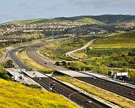
State Route 73 (SR 73) is a state highway in the U.S. state of California, running from the junction with Interstate 405 in Costa Mesa through the San Joaquin Hills to its junction with Interstate 5 in San Juan Capistrano, its northern and southern termini, respectively. The entirety of the route is located in Orange County. From its southern terminus, the first twelve miles 12 miles (19 km) of the highway are a toll road, which opened in November 1996. This segment of SR 73 is operated by the San Joaquin Hills Transportation Corridor Agency named the San Joaquin Hills Transportation Corridor. The last 3 miles (4.8 km) of the 15-mile (24 km) highway, which opened in 1978, are part of the Corona del Mar Freeway. SR 73's alignment follows an approximately parallel path between the Pacific Coast Highway and the San Diego Freeway. For the three mile freeway segment, there are no HOV lanes currently, but the medians have been designed with sufficient clearance for their construction should the need arise in the future.
Route description
SR 73 begins in San Juan Capistrano at an interchange with I-5. The freeway heads northwest into the city of Laguna Niguel before the tolled portion begins at the Greenfield Drive exit. After passing Greenfield Drive, SR 73 enters into the city of Aliso Viejo before entering Laguna Beach, where SR 73 intersects SR 133 with a separated-grade exit. Following this, the road passes through Crystal Cove State Park, where the main toll plazas are located. After leaving the state park, SR 73 straddles the border between Irvine and Newport Beach and provides easy access to University of California, Irvine through the Bison Avenue exit. Following the MacArthur Boulevard exit, the tolled part of the road ends and becomes a freeway. SR 73 continues into Newport Beach, running along the southern boundary of Orange County John Wayne Airport (IATA Airport Code SNA). Entering Costa Mesa, SR 73 interchanges with SR 55 before merging with I-405 and terminating the route.[2]
State Route 73 is part of the California Freeway and Expressway System,[3] and is part of the National Highway System,[4] a network of highways that are considered essential to the country's economy, defense, and mobility by the Federal Highway Administration.[5]
History
Most of State Route 73 is a limited-access toll highway designed to reduce congestion within Orange County on the Pacific Coast Highway (State Route 1) and the San Diego Freeway (Interstates 5, and 405) by providing a direct route through the San Joaquin Hills.
State Route 73 is not a toll road over its entire length. From its northbound terminus heading southbound, the first three miles (4.8 km) of State Route 73 have no tolls and make up the entire Corona Del Mar Freeway. State Route 73's previous alignment had the freeway portion end at MacArthur Boulevard, and the SR 73 designation ran along MacArthur south to meet Route 1 in Corona del Mar. Under the current alignment, heading southbound, State Route 73 becomes a designated toll road immediately after the Jamboree/MacArthur ramp and remains so until its southern terminus at I-5. Though the next ramp heading southbound (Bison Avenue) is part of the toll road, it is toll-free, as is the first ramp heading northbound from the southern terminus (Greenfield Drive).
Design and construction of the highway cost a total of $800 million. The design and construction was overseen by the San Joaquin Hills Transportation Corridor Agencies, or SJHTCA, an agency formed in 1988[6] for the express purpose of designing the tollway. In the end, State Route 73 included 10 interchanges, 68 bridges, 725,000 square feet (67,400 m2) of retaining walls, and 32 million cubic yards (24,000,000 m3) of excavation at completion. Construction was divided into four different sections, each with its own management system and quality control. A joint venture led by Kiewit Pacific Co., a subsidiary of Kiewit Corporation, completed this project.
State Route 73's toll road was the first to be financed with tax-exempt bonds on a stand-alone basis including construction and environmental risk. In 2011, $2.1 billion in debt for the San Joaquin Hills toll roads was restructured, which pushed back the time until the bonds are paid off and the route becomes a state-owned freeway to 2042.[7] In 2014, the debt was again restructured in an attempt to get improved interest rates, improved debt ratings,[8] and in the process save 44 million in debt repayment. This resulted in another 8 years of payments, delaying the pay-off date to 2050.[9] Under this new plan the debt can be paid off earlier than 2050, if ridership and revenue improves.[8]
Tolls
The following table lists the tolls at each of the tolled exits for passenger cars and other two-axle vehicles (as of July 1, 2015). Vehicles with more than two axles pay a higher toll at the Catalina View Toll Plaza.[10]
| Toll Booth | FasTrak | Toll-by-plate ExpressAccount | One-time payment |
|---|---|---|---|
| Bonita Canyon Dr Southbound Exit and Northbound Entrance | $1.02 | $2.02 | $2.02 |
| Newport Coast Dr Southbound Exit and Northbound Entrance | $2.31 | $3.31 | $3.31 |
| CATALINA VIEW TOLL PLAZA Price assumes 2-axle automobile. |
Peak: $6.78 Pre/Post Peak: $6.48 Off-Peak: $5.25 Weekends: $5.00 |
Peak: $7.78 Pre/Post Peak: $7.48 Off-Peak: $6.25 Weekends: $6.00 |
All times: $7.48 |
| El Toro/Laguna Canyon Rd Northbound Exit and Southbound Entrance | $2.57 | $3.57 | $3.57 |
| Aliso Creek Rd Northbound Exit and Southbound Entrance | $1.95 | $2.95 | $2.95 |
| La Paz Road/Moulton Pkwy Northbound Exit and Southbound Entrance | $1.37 | $2.37 | $2.37 |
The tolls on SR 73 begin only after the Bison Ave. exit in the southbound direction. In the northbound direction, there is a toll in effect after Greenfield Drive, the first ramp north of the highway's terminus. The road employs a barrier toll system, where drivers are charged flat-rate tolls based on what particular toll booths they pass through. Travelers who drive the entire length of the 73 will only encounter one toll booth, the Catalina View Toll Plaza, which uses a congestion pricing scheme based on the time of day. Patrons who use an exit along the toll road are charged a prorated toll.[11]
Only certain entrance and exit ramps are tolled:[11]
| Interchange (from south to north) |
Directions tolled |
|---|---|
| Moulton Parkway | No toll |
| La Paz Road | Northbound exit and southbound entrance |
| Aliso Creek Road | Northbound exit and southbound entrance |
| Pacific Park Drive, Glenwood Drive | No toll |
| El Toro Road | Northbound exit and southbound entrance |
| Northbound exit and southbound entrance | |
| Catalina View toll plaza | Both directions |
| Newport Coast Drive | Southbound exit and northbound entrance |
| Bonita Canyon | Southbound exit and northbound entrance |
Since May 13, 2014, the road has been using an all-electronic, open road tolling system; cash is no longer being accepted.[12] Drivers may pay using the FasTrak electronic toll collection system, license plate tolling (under Transportation Corridor Agencies's brand name "ExpressAccount"), or via a one time payment online. Those using Fastrak are charged a lower toll than those using the other two methods. Drivers must pay within 5 days after their trip on the toll road or they will assessed a toll violation.[13]
Exit list
Except where prefixed with a letter, postmiles were measured on the road as it was in 1964, based on the alignment that existed at the time, and do not necessarily reflect current mileage. R reflects a realignment in the route since then, M indicates a second realignment, L refers an overlap due to a correction or change, and T indicates postmiles classified as temporary (for a full list of prefixes, see the list of postmile definitions).[1] Segments that remain unconstructed or have been relinquished to local control may be omitted. The entire route is in Orange County.
| Location | Postmile [1][14][15] | Exit [16] | Destinations | Notes | |
|---|---|---|---|---|---|
| San Juan Capistrano | 10.00 | — | South end of SR 73; I-5 north exit 85A; no access to I-5 north | ||
| Laguna Niguel | 11.76 | 2 | Greenfield Drive | South end of toll road | |
| Aliso Viejo | 12.91 | 3 | Moulton Parkway | Southbound exit and northbound entrance | |
| 13.40 | 3 | La Paz Road | |||
| 14.39 | 4 | Aliso Creek Road | |||
| 15.25 | 5 | Pacific Park Drive, Glenwood Drive | Southbound exit and northbound entrance | ||
| Aliso Viejo–Laguna Beach line | 16.25 | 6 | El Toro Road (CR S18) | Southbound access is via exit 7 | |
| Laguna Beach | 16.75 | 7 | Northbound access is via exit 6 | ||
| San Joaquin Hills | 18.70 | Catalina View toll plaza | |||
| Irvine | 21.43 | 11 | Newport Coast Drive | ||
| 22.45 | 12 | Bonita Canyon Drive | |||
| 23.46 | 13 | Bison Avenue | |||
| Newport Beach | 23.82 | 14 | No southbound exit; north end of toll road | ||
| 23.82 | 14A | MacArthur Boulevard south – Newport Beach | Southbound exit and northbound entrance; former SR 73 south | ||
| 24.36 | 14B | University Drive | Southbound exit and northbound entrance | ||
| R24.78 | 15 | Jamboree Road | No northbound exit | ||
| R25.45 | 15 | Birch Street | Northbound exit and southbound entrance | ||
| R25.58 | 16 | Campus Drive, Irvine Avenue | Southbound exit and northbound entrance | ||
| Costa Mesa | R26.58 | 17A | Northbound exit and southbound entrance; SR 55 exit 5A | ||
| R26.58 | 17B | Signed as exit 17A southbound; SR 55 exit 5A | |||
| R27.28 | 17C | Bear Street | Signed as exit 17B southbound | ||
| | 18B | Fairview Road | Northbound exit and southbound entrance | ||
| | — | Harbor Boulevard | Northbound exit only; includes direct exit ramp to Susan Street | ||
| R27.81 | 18A | North end of SR 73; I-405 south exit 10; no access to I-405 south | |||
1.000 mi = 1.609 km; 1.000 km = 0.621 mi
| |||||
See also

References
- 1 2 3 California Department of Transportation. "State Truck Route List". Sacramento: California Department of Transportation. Archived from the original (XLS file) on June 30, 2015. Retrieved June 30, 2015.
- ↑ Orange County Street Atlas (Map). Thomas Brothers. 2008.
- ↑ California State Legislature. "Section 250–257". Streets and Highways Code. Sacramento: California State Legislature. Retrieved June 9, 2017.
- ↑ Federal Highway Administration (March 25, 2015). National Highway System: Los Angeles, CA (PDF) (Map). Scale not given. Washington, DC: Federal Highway Administration. Retrieved October 13, 2017.
- ↑ Natzke, Stefan; Neathery, Mike & Adderly, Kevin (June 20, 2012). "What is the National Highway System?". National Highway System. Washington, DC: Federal Highway Administration. Retrieved July 1, 2012.
- ↑ http://www.newportcoastdrive.com Exhibit 30. page 4. "On October 17, 1988, the County and city members of the TCA amended the Joint Powers Agreement to exercise the power authorized by the legislature to impose and collect tolls on the Corridor"
- ↑ TheTollRoads.com Press Release May 2011
- 1 2 "Reuters, S&P Improves Debt Rating to Investment Grade". October 8, 2014. Retrieved May 24, 2015.
- ↑ TheTollRoads.com Press Release Oct 2014
- ↑ "The Toll Roads Rate Card" (PDF). July 1, 2015. Archived from the original (PDF) on March 31, 2012. Retrieved July 9, 2015.
- 1 2 "The Toll Roads Rate Card" (PDF). July 1, 2015. Archived from the original (PDF) on March 31, 2012. Retrieved July 9, 2015.
- ↑ "All Electronic Tolling". Transportation Corridor Agencies. Archived from the original on October 16, 2012. Retrieved October 12, 2013.
- ↑ "The Toll Roads Overview". Transportation Corridor Agencies. Retrieved December 29, 2013.
- ↑ California Department of Transportation (July 2007). "Log of Bridges on State Highways". Sacramento: California Department of Transportation.
- ↑ California Department of Transportation, All Traffic Volumes on CSHS, 2005 and 2006
- ↑ California Department of Transportation, California Numbered Exit Uniform System, State Route 73 Freeway Interchanges, Retrieved on 2009-02-07.
External links
| Wikimedia Commons has media related to California State Route 73. |
Route map: