Cajacay District
| Cajacay | |
|---|---|
| District | |
 | |
| Country |
|
| Region | Ancash |
| Province | Bolognesi |
| Founded | January 2, 1857 |
| Capital | Cajacay |
| Government | |
| • Mayor | Joaquin Edmundo Castillo Sarazu |
| Area | |
| • Total | 193.06 km2 (74.54 sq mi) |
| Elevation | 2,599 m (8,527 ft) |
| Population (2005 census) | |
| • Total | 1,748 |
| • Density | 9.1/km2 (23/sq mi) |
| Time zone | UTC-5 (PET) |
| UBIGEO | 020505 |
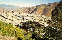
Cajacay District is one of fifteen districts of the Bolognesi Province in Peru.[1]
Geography
One of the highest peaks of the district is Kushuru Punta at approximately 4,800 m (15,700 ft). Other mountains are listed below:[2]
- Chakwa Pukyu
- Ch'illka Raqra
- Hatun Punta
- Hirkan Wayi
- Ichik Punta
- Inka Waqanqa
- Kima Wank'a
- Mina Punta
- Pichaq Wayin
- Qucha Marka
- Quraw
- Tuku Wachanan
- Yana Punta
- Yuraq Punta
References
- ↑ (in Spanish) Instituto Nacional de Estadística e Informática. Banco de Información Distrital Archived April 23, 2008, at the Wayback Machine.. Retrieved April 11, 2008.
- ↑ escale.minedu.gob.pe/ UGEL map Carlos Fermín Fitzcarrald Province (Ancash Region)
| Aija | |
|---|---|
| Antonio Raymondi | |
| Asunción | |
| Bolognesi | |
| Carhuaz | |
| Carlos Fermín Fitzcarrald | |
| Casma | |
| Corongo | |
| Huaraz | |
| Huari | |
| Huarmey | |
| Huaylas | |
| Mariscal Luzuriaga | |
| Ocros | |
| Pallasca | |
| Pomabamba | |
| Recuay | |
| Santa | |
| Sihuas | |
| Yungay | |
{{coord|10|08|26|S|77|26|36|W|type:landmark_source:kolossus-eswiki|display=title
This article is issued from
Wikipedia.
The text is licensed under Creative Commons - Attribution - Sharealike.
Additional terms may apply for the media files.