Independencia District, Huaraz
| Independencia | ||
|---|---|---|
| District | ||
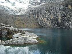 Churup Lake, Independencia District | ||
| ||
| Country |
| |
| Region | Ancash | |
| Province | Huaraz | |
| Founded | November 16, 1992 | |
| Capital | Centenario | |
| Government | ||
| • Mayor | Gregorio Emiliano Mezarina Paredes | |
| Area | ||
| • Total | 342.95 km2 (132.41 sq mi) | |
| Elevation | 3,049 m (10,003 ft) | |
| Population (2005 census) | ||
| • Total | 61,705 | |
| • Density | 180/km2 (470/sq mi) | |
| Time zone | UTC-5 (PET) | |
| UBIGEO | 020105 | |

Independencia District is one of twelve districts of the province Huaraz in Peru.[1]
Geography
The Cordillera Blanca traverses the district. Some of the highest peaks of the district are Pallqarahu, Pukaranra, Ranrapallqa and Rurichinchay. Other mountains are listed below:[2]
See also
References
- ↑ (in Spanish) Instituto Nacional de Estadística e Informática. Banco de Información Distrital Archived 2008-04-23 at the Wayback Machine.. Retrieved April 11, 2008.
- ↑ escale.minedu.gob.pe - UGEL map of the Huaraz Province (Ancash Region)
| Aija | |
|---|---|
| Antonio Raymondi | |
| Asunción | |
| Bolognesi | |
| Carhuaz | |
| Carlos Fermín Fitzcarrald | |
| Casma | |
| Corongo | |
| Huaraz | |
| Huari | |
| Huarmey | |
| Huaylas | |
| Mariscal Luzuriaga | |
| Ocros | |
| Pallasca | |
| Pomabamba | |
| Recuay | |
| Santa | |
| Sihuas | |
| Yungay | |
This article is issued from
Wikipedia.
The text is licensed under Creative Commons - Attribution - Sharealike.
Additional terms may apply for the media files.