Huata District, Huaylas
| Huata | ||
|---|---|---|
| District | ||
| ||
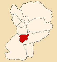 Location of Huata in the Huaylas province | ||
| Country |
| |
| Region | Ancash | |
| Province | Huaylas | |
| Founded | January 2, 1857 | |
| Capital | Huata | |
| Subdivisions | 1 village, 13 hamlets and 40 anexos | |
| Government | ||
| • Mayor | Miguel Abilio Terry Guerrero | |
| Area | ||
| • Total | 70.69 km2 (27.29 sq mi) | |
| Elevation | 2,736 m (8,976 ft) | |
| Population (2002 est.) | ||
| • Total | 1,941 | |
| • Density | 27/km2 (71/sq mi) | |
| Time zone | UTC-5 (PET) | |
| UBIGEO | 021203 | |
| Website | munihuata.gob.pe | |
The Huata District (Spanish: Distrito de Huata) is the smallest of the 10 districts of the Huaylas Province in the Ancash Region of Peru. The capital of the district is the village of Huata.[1]
History
The district was founded on January 2, 1857.
Location
The district is located in the central part of the province at an elevation of 2,736m in the black mountains (Spanish: Cordillera Negra), neighboring district is the Caraz district in which the provinces capital Caraz is located, 17 km from the village of Huata.
Political division
The Huata District is divided into 1 village (Spanish: pueblos, singular: pueblo), 6 hamlets (Spanish: caseríos, singular: caserío) and 40 (Spanish: anexos, singular: anexo):
Villages
- Huata
Hamlets
- Cancho
- Inchapampa
- Parcap
- Racracallan
- Ranca
- Tambillo
Anexos
- Caulla
- Cashapuro
- Animas
- Molino
- Tunanpuquio
- Shaquipampa
- Tranca
- Huerco
- Pichipuquio
- Puca Rumi
- Mosqueta
- Mandahuas
- Colcash
- Anascallan (Choccho)
- Rachinac
- Higos
- Cotu
- Cocha Cocha
- Lauricocha
- La Fronda
- Ampicallan
- Zanja
- Cahu Nuevo
- Pato Raca
- Cucuri
- Ancaranac
- Pichi Alta
- Cedro
- Quespac
- Huachcuyoc
- Nauya
- Yuracpacha
- Alalacpampa
- Pacayo (Pucllanca)
- Maraypampa
- Malambo
- Ocuyoc
- Rayan
- Huancayoc
- Ache
Capital
The capital of the Huata district is the city of Huata.
Climate
The district has a temperate and dry climate with a temperature varying from 12 to 19 degrees Celsius.
Traditional festivals
- VIRGEN DEL ASUNCION on August 15
- FIESTA DEL MILAGRO on September 11
- VIRGEN DE LAS MERCEDES on September 24
- FIESTA DE ANIVERSARIO DE CREACION POLITICA on January 2
References
- ↑ Official web site of the Huata District in the Huaylas province Archived 2007-04-24 at the Wayback Machine.
External links
- (in Spanish) Official web site of the Huaylas province
| Aija | |
|---|---|
| Antonio Raymondi | |
| Asunción | |
| Bolognesi | |
| Carhuaz | |
| Carlos Fermín Fitzcarrald | |
| Casma | |
| Corongo | |
| Huaraz | |
| Huari | |
| Huarmey | |
| Huaylas | |
| Mariscal Luzuriaga | |
| Ocros | |
| Pallasca | |
| Pomabamba | |
| Recuay | |
| Santa | |
| Sihuas | |
| Yungay | |