Cairngorms National Park
| Cairngorms National Park | |
|---|---|
|
IUCN category V (protected landscape/seascape) | |
 | |
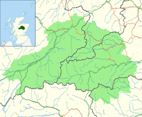
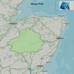 Location and extent of the Cairngorms National Park | |
| Location | Cairngorms, Scotland, Moray, Aberdeenshire, Highland, Angus, Perth and Kinross |
| Coordinates | 57°5′N 3°40′W / 57.083°N 3.667°WCoordinates: 57°5′N 3°40′W / 57.083°N 3.667°W |
| Area | 1,748 sq mi (4,530 km2) |
| Established | 2003 |
| Governing body | National Park Authority |
| Official name | Cairngorm Lochs |
| Designated | 24 July 1981 |
| Reference no. | 216[1] |
Cairngorms National Park (Scottish Gaelic Pàirc Nàiseanta a' Mhonaidh Ruaidh) is a national park in north east Scotland, established in 2003. It was the second of two national parks established by the Scottish Parliament, after Loch Lomond and The Trossachs National Park, set up in 2002. The park covers the Cairngorms range of mountains, and surrounding hills. Already the largest national park in the British Isles, in 2010 it expanded into Perth and Kinross.[2]
The area
Cairngorms National Park covers an area of 4,528 km2 (1,748 sq mi) in Aberdeenshire, Moray, Highland, Angus and Perth and Kinross Regions. The Cairngorm Mountains are a spectacular landscape, similar in appearance to the Hardangervidda National Park of Norway in having a large upland plateau. While the Hardangervidda National Park is recognised as a Category 2 national park under the IUCN categories (no activity that has a lasting impact on the natural environment is permitted) the Cairngorm National Park is a Category 5 protected landscape (sustainable development area) that has farmed and managed landscapes in which tourism is encouraged. Aviemore is a busy and popular holiday destination. The Highland Wildlife Park and Dalwhinnie distillery also lie within the National Park. In 2015, 53 km (33 mi) of the 132 kV power line in the middle of the park was taken down, while another section along the edge of the park was upgraded to 400 kV.[3]
A skiing and winter sports industry is concentrated in the Cairngoms, with three of Scotland's five resorts situated here. They are the Cairn Gorm Ski Centre, Glenshee Ski Centre and The Lecht Ski Centre.
The Frank Bruce Sculpture Trail is located near Feshiebridge. This short trail through the woods features a sculptures created by Frank Bruce between 1965 and 2009.[4]
National park boundary
Before the national park was established in 2003, Scottish Natural Heritage conducted a consultation exercise, considering the boundary and the powers and structure of the new park authority.[5] One option presented for the area included Tomatin, Blair Atholl, Aboyne and Glen Shee, making the park twice as big as the Lake District National Park. The area finally chosen was smaller than expected, but still the largest in Britain. It involved the boundary areas of Carrbridge, Laggan, Dalwhinnie, Grantown-on-Spey and Ballater. Many groups and local communities felt that a large area of highland Perth and Kinross should form part of the park and carried out a sustained campaign.
On 13 March 2008 Michael Russell announced that the National Park would be extended to take in Blair Atholl and Spittal of Glenshee.[6] There was also controversy surrounding the construction of the funicular Cairngorm Mountain Railway on Cairn Gorm, a scheme supported by the new National Park Authority. Supporters of the scheme claimed that it would bring in valuable tourist income, whilst opponents argued that such a development was unsuitable for a protected area. To reduce erosion, the railway operates a "closed scheme" and only allows skiers (in season) out of the upper Ptarmigan station.
On 4 October 2010 the Park extended into Highland Perthshire and Glenshee.[2]
Settlements within the national park
The National Park Authority shares statutory planning functions with the five local authorities[7] within the national park boundary.[8]
Aberdeenshire
(All in the Marr committee area)
Angus
Only the heads of the Angus Glens are within the park; they only contain one village.
Highland
(All in the Badenoch and Strathspey committee area, nearly the entire area of which is in the national park)
- Aviemore
- Boat of Garten
- Carrbridge
- Dalwhinnie
- Dulnain Bridge (Moray and Highland are separated by the bridge, so falls into both categories.)
- Drumochter
- Grantown-on-Spey
- Kingussie
- Laggan
- Nethy Bridge
- Newtonmore
Moray
Perth and Kinross
See also
References
- ↑ "Cairngorm Lochs". Ramsar Sites Information Service. Retrieved 25 April 2018.
- 1 2 "Cairngorms National Park boundary extended". BBC News. 4 October 2010. Retrieved 14 January 2016.
- ↑ https://www.ssepd.co.uk/BeaulyDenny/
- ↑ Brian Johnson, Walking the Corbetts Vol 1 South of the Great Glen (Cicerone Press, 2012), ISBN 1852846526, p. 269=71.
- ↑ Ross, John (25 September 2002). "MSPs to consider Cairngorms park issues". The Scotsman. Retrieved 12 November 2017.
- ↑ "Cairngorms National Park". Scottish Government. 13 March 2008. Retrieved 2008-03-22.
- ↑ Planning at Cairngorms National Park Authority
- ↑ Map Archived 2007-03-03 at the Wayback Machine. at Cairngorms National Park Authority
External links
| Wikimedia Commons has media related to Cairngorms National Park. |
- Cairngorms National Park Authority website
- Cairngorms National Park website for accommodation and activities
Settlements and places of interest in Marr, Aberdeenshire | ||
|---|---|---|
| Primary settlements | 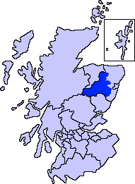 | |
| Other settlements | ||
| Places of interest |
| |