Cıfıtkalesi Islet
| Native name: Cıfıtkalesi Adası | |
|---|---|
 Cıfıtkalesi | |
 Cıfıtkalesi Islet | |
| Geography | |
| Coordinates | 38°02′44″N 26°51′18″E / 38.04556°N 26.85500°E |
| Administration | |
| İl (province) | İzmir Province |
| İlçe | Seferihisar |
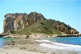
Çıfıtkalesi Islet (literally "Jewish Castle Island") is an uninhabited Aegean islet in Turkey.
The islet at 38°02′44″N 26°51′18″E / 38.04556°N 26.85500°E [1] is administratively a part of Seferihisar ilçe (district) of İzmir Province. It is very close to mainland (Anatolia); the closest point to mainland is less than 100 metres (330 ft). The longest dimension of the islet is about 250 metres (820 ft). [2]
In the antiquty the islet was connected to the mainland (Myonnesos). Currently the connection has been broken . But the sea level is shallow and it is possible to walk to the islet . There are some ruins in the islet.
References
This article is issued from
Wikipedia.
The text is licensed under Creative Commons - Attribution - Sharealike.
Additional terms may apply for the media files.