Byer Covered Bridge
|
Byer Covered Bridge | |
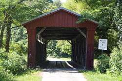 Photo in 2015 | |
 | |
| Location | SR 31, Byer, Ohio |
|---|---|
| Coordinates | 39°10′46″N 82°37′52″W / 39.17944°N 82.63111°WCoordinates: 39°10′46″N 82°37′52″W / 39.17944°N 82.63111°W |
| Area | less than one acre |
| Built | c.1870 |
| Architectural style | Smith Truss |
| NRHP reference # | 75001441[1] |
| Added to NRHP | October 21, 1975 |
The Byer Covered Bridge, on SR 31 in Byer, Ohio, is a covered bridge built in c.1870. It was listed on the National Register of Historic Places in 1975. It has a Smith truss span.[1]
.jpg)
Bridge in 2000, over green water perhaps caused by coal mine runoff
It is a single-span wooden structure "lying on the banks of Pigeon Creek within the Wayne National Forest".[2]
References
- 1 2 National Park Service (2013-11-02). "National Register Information System". National Register of Historic Places. National Park Service.
- ↑ Lorrie K. Owen, ed. (1999). "Ohio Historic Places Dictionary, Volume 2". Somerset Publishers, Inc. p. 792.
External links

| Topics | |
|---|---|
| Lists by states |
|
| Lists by insular areas | |
| Lists by associated states | |
| Other areas | |
| |
This article is issued from
Wikipedia.
The text is licensed under Creative Commons - Attribution - Sharealike.
Additional terms may apply for the media files.