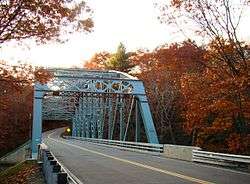
Butts Bridge
|
Butts Bridge | |
.jpg) Butts Bridge | |
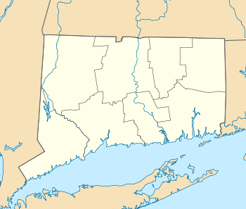  | |
| Location | Butts Bridge Rd. over Quinebaug R., Canterbury, Connecticut |
|---|---|
| Coordinates | 41°39′5″N 71°58′15″W / 41.65139°N 71.97083°WCoordinates: 41°39′5″N 71°58′15″W / 41.65139°N 71.97083°W |
| Area | 0.2 acres (0.081 ha) |
| Built | 1936 |
| Architect | Connecticut State Highway Dept.; et al. |
| Architectural style | Other, Parker through truss |
| NRHP reference # | 10000272[1] |
| Added to NRHP | May 24, 2010 |
The Butts Bridge carries Butts Bridge Road (Connecticut Route 668) over the Quinebaug River in the town of Canterbury, Connecticut. It was completed in 1937 by the Fort Pitt Bridge Works company using designs by the Connecticut State Highway Department. The bridge is a single-span steel Parker truss design that typifies truss bridges of the early automotive age. It is 231 feet 6 inches (70.56 m) long, and is 31 feet (9.4 m) between the centers of the trusses. The trusses are mounted on concrete abutments, and the roadway is supported by concrete decking.[2] It was built as part of the Highway Department's emergency relief program after the Northeast Flood of 1936. The bridge is also known as Bridge No. 1649 and carries an average of 2,300 vehicles per day as of 2011.
Gallery
 Quinebaug River from Butts Bridge
See also
References
- ↑ National Park Service (2010-07-09). "National Register Information System". National Register of Historic Places. National Park Service.
- ↑ "Notice of public meeting re rehabilitation of Bridge No. 0164". Connecticut Department of Transportation. Retrieved 2015-01-07.
External links
- Connecticut Department of Transportation, News Release: Public Information Meeting - Rehabilitation of Bridge No. 01649, October 15, 2008
| Topics | |
|---|---|
| Lists by states |
|
| Lists by insular areas | |
| Lists by associated states | |
| Other areas | |
| |