Burnt House, West Virginia
| Burnt House, West Virginia | |
|---|---|
| Unincorporated community | |
 Burnt House, West Virginia  Burnt House, West Virginia | |
| Coordinates: 39°02′47″N 80°59′14″W / 39.04639°N 80.98722°WCoordinates: 39°02′47″N 80°59′14″W / 39.04639°N 80.98722°W | |
| Country | United States |
| State | West Virginia |
| County | Ritchie |
| Elevation | 817 ft (249 m) |
| Time zone | UTC-5 (Eastern (EST)) |
| • Summer (DST) | UTC-4 (EDT) |
| ZIP code | 26336 |
| Area code(s) | 304 & 681 |
| GNIS feature ID | 1554036[1] |
Burnt House is an unincorporated community in Ritchie County, West Virginia, United States. Burnt House is located on West Virginia Route 47 and Grassy Run 11.8 miles (19.0 km) south-southeast of Harrisville.[2] The Burnt House Post Office closed 5/23/1986.[3]
The community's name recalls a tavern which burned at the town site around 1840.[4]
References
- ↑ "Burnt House". Geographic Names Information System. United States Geological Survey.
- ↑ Ritchie County, West Virginia General Highway Map (PDF) (Map). West Virginia Department of Transportation. 2011. p. 2. Archived from the original (PDF) on April 25, 2012. Retrieved December 27, 2011.
- ↑ http://webpmt.usps.gov/pmt015.cfm%5Bpermanent+dead+link%5D
- ↑ Kenny, Hamill (1945). West Virginia Place Names: Their Origin and Meaning, Including the Nomenclature of the Streams and Mountains. Piedmont, WV: The Place Name Press. p. 144.
Municipalities and communities of Ritchie County, West Virginia, United States | ||
|---|---|---|
| City | 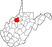 | |
| Towns | ||
| Unincorporated communities |
| |
| Ghost towns | ||
| Footnotes | ‡This populated place also has portions in an adjacent county or counties | |
This article is issued from
Wikipedia.
The text is licensed under Creative Commons - Attribution - Sharealike.
Additional terms may apply for the media files.