Burncoose
Burncoose
| |
|---|---|
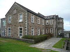 Camborne Redruth Community Hospital, Burncoose | |
 Burncoose Burncoose shown within Cornwall | |
| OS grid reference | SW741395 |
| Civil parish |
|
| Unitary authority | |
| Ceremonial county | |
| Region | |
| Country | England |
| Sovereign state | United Kingdom |
| Post town | REDRUTH |
| Postcode district | TR16 |
| Dialling code | 01872 |
| Police | Devon and Cornwall |
| Fire | Cornwall |
| Ambulance | South Western |
| EU Parliament | South West England |
| UK Parliament | |
Burncoose is a hamlet near Gwennap in west Cornwall, England; Burncoose lies on the A393 road, 4 miles (6.4 km) south-east of Redruth.[1][2] It was first recorded in 1277 as Burncoys, an anglicized name from the Cornish Broncoos, meaning "wood hill".[3]
See also
References
- ↑ Google (8 January 2016). "Burncoose" (Map). Google Maps. Google. Retrieved 8 January 2016.
- ↑ Ordnance Survey One-inch Map of Great Britain; Truro and Falmouth, sheet 190. 1961
- ↑ Weatherhill, Craig (2009) A Concise Dictionary of Cornish Place-names. Westport, Mayo: Evertype; p. 26
Further reading
- Burncoose Gardens: a garden oasis in the minewastes of Cornwall; by F. J. Williams C.B.E., Arnold Dance, David Knuckey.
Cornwall Portal | |
| Unitary authorities | |
| Major settlements |
|
| Rivers | |
| Topics | |
This article is issued from
Wikipedia.
The text is licensed under Creative Commons - Attribution - Sharealike.
Additional terms may apply for the media files.