Burlington Bay James N. Allan Skyway
| Burlington Bay James N. Allan Skyway | |
|---|---|
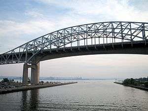 The Burlington Bay James N. Allan Skyway, taken in July 2004. The 1958 steel arch span carries QEW Toronto-bound traffic, and is in front of the 1985 concrete span, which carries Niagara-bound traffic. In the background is the Hamilton Harbour. | |
| Coordinates | 43°17′58″N 79°47′53″W / 43.29945°N 79.79799°WCoordinates: 43°17′58″N 79°47′53″W / 43.29945°N 79.79799°W |
| Carries |
8 lanes of |
| Crosses | Hamilton Harbour |
| Locale | Hamilton, Ontario and Burlington, Ontario |
| Other name(s) | Burlington Skyway |
| Owner | Government of Ontario |
| Maintained by | Ontario Ministry of Transportation |
| Characteristics | |
| Design |
steel through arch bridge - 1958 span Concrete box girder - 1985 span |
| Total length |
2,560 metres (8,400 ft) - 1958 span 2,215 metres (7,267 ft) - 1985 span |
| Width | 30 metres (98 ft) |
| Height | 64 metres (210 ft) |
| Longest span | 151 metres (495 ft) - 1958 span |
| Clearance below | 36.7 metres (120 ft) - 1958 span |
| History | |
| Architect | John Turner Bell |
| Designer | Philip Louis Pratley |
| Construction cost | CA$12 /million to CA$17,000,000 (equivalent to $145,840,000 in 2017)[1][2] |
| Opened |
October 30, 1958 (Northbound structure) October 11, 1985 (Southbound structure) |
| Rebuilt | 1985–88 (1958 span) |
| Statistics | |
| Daily traffic | 149,000 per day (2014) [3] |
| Toll | 1958-1973 |
 Burlington Bay James N. Allan Skyway Location in Southern Ontario | |
The Burlington Bay James N. Allan Skyway, originally called the Burlington Bay Skyway and simply known as the Burlington Skyway, is a pair of high-level freeway bridges (built in 1958 and 1985) spanning the Burlington Bay Canal. The Skyway, as it is locally known, is located in Hamilton and Burlington, Ontario, Canada, and is part of the Queen Elizabeth Way (QEW) highway linking Fort Erie with Toronto.
1958 arch bridge
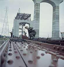
The first bridge (steel structure) was completed in 1958 and officially opened October 30, 1958,[4] crossing the narrow bar separating Hamilton Harbour from Lake Ontario. This allows for Great Lakes ship traffic to flow underneath while four lanes of Golden Horseshoe road traffic may flow on top of it, neither disturbing the other. The bridge was designed by John Turner Bell.[5] Construction of the entire Skyway required 20,000 short tons (18,000 t) of steel and 90,000 cubic yards (69,000 m3) of concrete.[6]
The bridge had tolls when constructed, but these were removed December 28, 1973[4] after they were found to heavily impede traffic flow (The toll plaza was located near Tower' Drive). Truck drivers in particular had refused to take the tolled bridge since not only were they charged the full toll but also it took them extra fuel to ascend the Skyway.[7] With the lifting of tolls on the bridge, trucks were then banned from using Beach Boulevard.
1985 twin bridge
When traffic volume became more than the bridge could accommodate in the early 1980s, the bridge was twinned. The 1985 bridge was a conventional precast concrete box girder. When the new skyway (concrete structure) was opened on October 11, 1985,[4] traffic was temporarily rerouted to it so that the old bridge could be extensively rehabilitated and this work was completed August 22, 1988.[4][7] Afterwards, there were eight lanes of traffic crossing the harbour.
The twinning project also saw a major upgrade of the freeway approaches to the bridge. The entire project resulted in the QEW being widened to eight lanes from Burlington Street to Highway 403, with modern Parclo interchanges at Burlington Street, Northshore Boulevard (former Highway 2), and Fairview Street/Plains Road. This section has a variable lighting system to overcome the frequent fog found in the area. It is also the site of Ontario's first freeway traffic management system which incorporates traffic cameras and changeable message signs.
Design
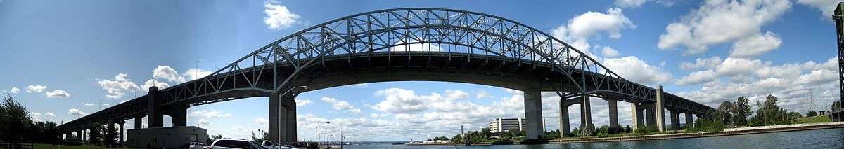
The 1958 steel bridge is a suspended deck through-arch truss bridge. The approach to the main span has elements of a through-truss bridge, but the arch shape takes the truss higher than the roadway deck, so hangers are used to suspend the deck from the arch truss. The 1958 bridge is 2,560 m (8,400 ft) long overall. The main span of 151 m (495 ft) is flanked by two back spans each 83.7 m (275 ft) long; there are 72 total approach spans, and the bridge has 36.7 m (120 ft) of vertical clearance below the bottom of the deck.[2]
A second bridge, completed in 1985, is 335 m (1,099 ft) shorter. The roadway deck for each bridge is 30 m (97 ft) wide.[4]
Naming
The original name of the first bridge was the Burlington Bay Skyway. After it was twinned, the proposed names of James N. Allan Skyway (in honour of the Ontario Minister of Highways James Noble Allan, who had championed the 1958 bridge) and James N. Allan Burlington Bay Skyway were rejected. The official name since 1988 has been Burlington Bay James N. Allan Skyway.[4][7]
Lift bridge
A federally owned[8] low-level lift bridge, Burlington Canal Lift Bridge, linking Beach Boulevard in the Hamilton neighbourhood of Hamilton Beach and Lakeshore Road in the Burlington neighbourhood of Burlington Beach continues to operate. Built in 1962, the current bridge is the sixth bridge spanning the waters since 1830.[9] This is mainly used by local traffic, although ramps from the QEW have been configured to allow easy access to the bridge and re-entry to the highway, should the Skyway bridge close because of high winds and adverse weather conditions, exacerbated by its towering height. The federal government attempted to transfer ownership of the bridge, but neither the province nor the Hamilton Port Authority were interested in assuming the estimated $2 million annual operating costs.[8]
Refurbishment and events
In fall 2008, most of the older Aluminum Tapered Leg (ATL) overhead sign gantries (commonly referred by the MTO as a "Type 1" structure) which had been installed back in the late 1980s were replaced with the newer triangular truss gantries.[10][11][12]
On July 31, 2014, a man driving a dump truck in its raised position crashed onto the top of the bridge frame on the Toronto-bound lanes.[13] The bridge was closed for the weekend to effect temporary repairs;[14] permanent repairs to the bridge structure took seven months and cost $1.224 million.[15] The driver was charged with impaired driving and tried in 2016, resulting in a conviction for dangerous driving in March 2016[16] and a one-year jail sentence.[17]
See also
- Garden City Skyway
- Gerald Desmond Bridge, a 1968 through-arch in Long Beach with similar design
References
- ↑ Bouchier, Nancy B.; Cruikshank, Ken (2016). "Confining Nature". The People and the Bay: A Social and Environmental History of Hamilton Harbour. Vancouver, British Columbia: UBC Press. pp. 145, 158–159. ISBN 978-0-7748-3044-7. Retrieved 7 December 2016.
- 1 2 Passfield, Robert W. (2007). "Philip Louis Pratley (1884–1958): bridge design engineer". Canadian Journal of Civil Engineering. 34 (5): 637–650. doi:10.1139/L06-130. alternate URL
- ↑ Van Dongen, Matthew; O'Reilly, Nicole (August 2, 2014). "Skyway bridge cleared after Thursday crash, lanes remain closed". Hamilton Spectator. Archived from the original on August 3, 2014. Retrieved August 1, 2014.
- 1 2 3 4 5 6 "Fast Facts from Hamilton's Past". Archived from the original on September 5, 2006. Retrieved January 8, 2007.
- ↑ "Burlington Skyway Bridge". Historic Bridges. 2016. Retrieved 7 December 2016.
- ↑ "Canada's First Skyway Opens 1958". Quebec Chronicle-Telegraph. 27 November 1957. Retrieved 7 December 2016.
- 1 2 3 "Oct. 30, 1958: Burlington Bay Skyway completed". Hamilton Spectator. 23 September 2016. Retrieved 7 December 2016.
- 1 2 Van Dongen, Matthew (21 February 2014). "No takers for offer of Burlington lift bridge". Hamilton Spectator. Retrieved 7 December 2016.
- ↑ http://www.tpsgc-pwgsc.gc.ca/ontario/burlington-eng.html
- ↑ "Ontario Highway 401 Photographs - Page 8 - History of Ontario's Kings Highways". Thekingshighway.ca. Retrieved August 1, 2014.
- ↑ "Queen Elizabeth Way - Ontario | Flickr - Photo Sharing!". Flickr. June 12, 2004. Retrieved August 1, 2014.
- ↑ "Queen Elizabeth Way - Stoney Creek to Burlington - Images". Asphaltplanet.ca. Retrieved August 1, 2014.
- ↑ Whitnell, Tim (31 July 2014). "Burlington Skyway Bridge damaged by dump truck". Hamilton Spectator. Retrieved 7 December 2016.
- ↑ O'Reilly, Nicole (4 August 2014). "UPDATE: Skyway Bridge to reopen between 6 and 8 p.m." Hamilton Spectator. Retrieved 7 December 2016.
- ↑ Hayes, Molly (31 July 2015). "Remember when a dump truck smashed into the Skyway Bridge?". Hamilton Spectator. Retrieved 7 December 2016.
- ↑ Peters, Ken (22 March 2016). "Skyway crash driver guilty of dangerous driving". Hamilton Spectator. Retrieved 7 December 2016.
- ↑ Moro, Teviah (19 July 2016). "'Shocking and frightening:' Burlington Skyway crash driver jailed a year". Hamilton Spectator. Retrieved 7 December 2016.
| Wikimedia Commons has media related to Burlington Bay James N. Allan Skyway. |