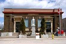
Burk's Falls
| Burk's Falls | |
|---|---|
| Village (single-tier) | |
| Village of Burk's Falls | |
 | |
 Burk's Falls | |
| Coordinates: 45°37′N 79°24′W / 45.617°N 79.400°WCoordinates: 45°37′N 79°24′W / 45.617°N 79.400°W | |
| Country |
|
| Province |
|
| District | Parry Sound |
| Settled | 1860s |
| Incorporation | 1890 |
| Government[1] | |
| • Reeve | Cathy Still |
| • Federal riding | Parry Sound—Muskoka |
| • Prov. riding | Parry Sound—Muskoka |
| Area[2] | |
| • Land | 3.07 km2 (1.19 sq mi) |
| Population (2016)[2] | |
| • Total | 981 |
| • Density | 319.2/km2 (827/sq mi) |
| Time zone | UTC-5 (Eastern (EST)) |
| • Summer (DST) | UTC-4 (EDT) |
| Postal Code | P0A 1C0 |
| Area code(s) | 705 |
| Website | burksfalls.net |
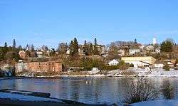
Burk's Falls is an incorporated village in the Almaguin Highlands region of Parry Sound District, Ontario, Canada, located 265 kilometres (165 mi) north of Toronto and 90 kilometres (56 mi) south of North Bay, Ontario. The village, and the waterfall on the site, were named (for himself) by David Francis Burk of Oshawa, after he selected the land surrounding the waterfall in the Free Land Grant Act.[3] Burk's Falls is part of the Magnetawan River waterway.
Geography
Located about 60 kilometres (37 mi) west of Algonquin Provincial Park in picturesque cottage country, Burk's Falls is at the intersection of Ontario Highway 11 and the Magnetawan River.[4] It is an enclave within Armour Township. The area is set amid the fresh-water bodies that make Northern Ontario famous; the largest of which are Horn Lake to the Northwest, Pickerel Lake to the Northeast, Three Mile Lake to the Southeast, and the joined Doe and Little Doe Lakes to the Southwest.
History
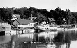
The area around Burk's Falls was first settled by loggers during the 1860s. At that time, the only access to the region was via the Magnetawan River from Georgian Bay, or through the forests of the unsurveyed townships, north of Bracebridge. After 1875 the Rosseau-Nipissing Colonization Road allowed access from Muskoka, to the south. In 1879 steamboat service was established to the foot of the falls, from the historic village of Magnetawan.[5] Railway service came to Burk's Falls in 1886, with the opening of Northern and Pacific Junction Railway, absorbed by the Grand Trunk Railway in 1888. The Village of Burk's Falls was incorporated in 1890.
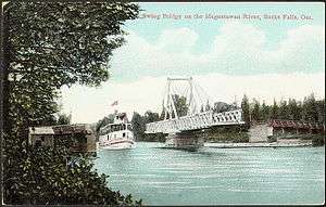
A rare swing bridge was completed over the Magnetawan, just west of Burk's Falls.[5]
Growth of the village
This growth has been limited and Burk's Falls has not amalgamated with any nearby towns such as Katrine. The population has remained steady over the last decades, standing around 1000. Expansion of Highway 11 as a dual carriageway has prompted a new interchange.
Also located in Burk's Falls is the Outward Bound Canadian Base Camp.
References
- ↑ "Burk's Falls Village Council". Archived from the original on 2008-05-08. Retrieved 2018-09-08.
- 1 2 "Burk's Falls census profile". 2011 Census of Population. Statistics Canada. Retrieved 2012-03-12.
- ↑ The Municipality of the Village of Burk's Falls Ontario, Canada
- ↑ Burks Falls, Ontario, Canada — Welcome to our thought-provoking, exciting Village
- 1 2 Astrid Taim (2016). "Astrid Taim's Almaguin Chronicles 2-Book Bundle: Almaguin / Almaguin Chronicles". Dundurn Press. ISBN 9781459737006. Retrieved 2018-09-08.
Demographics
| Canada census – Burk's Falls community profile | |||
|---|---|---|---|
| 2016 | 2011 | 2006 | |
| Population: | 981 (1.4% from 2011) | 967 (8.3% from 2006) | 893 (-5.0% from 2001) |
| Land area: | 3.07 km2 (1.19 sq mi) | 3.12 km2 (1.20 sq mi) | 3.12 km2 (1.20 sq mi) |
| Population density: | 319.2/km2 (827/sq mi) | 309.9/km2 (803/sq mi) | 286.1/km2 (741/sq mi) |
| Median age: | 44.8 (M: 43.8, F: 45.7) | 44.8 (M: 42.2, F: 48.9) | |
| Total private dwellings: | 510 | 476 | 480 |
| Median household income: | $34,457 | ||
| References: 2016[1] 2011[2] 2006[3] earlier[4] | |||
External links
- Map of Burk's Falls
- The Municipality of the Village of Burk's Falls Ontario, Canada
- Burks Falls.com
- Burk's Falls Ontario Almaguin Highlands Regional Portal
- Almaguin News
- 2011 Census Profile
| Towns | 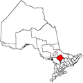 | |
|---|---|---|
| Townships | ||
| Villages | ||
| First Nations | ||
| Indian reserves | ||
| Local services boards | ||
| Unorganized areas | ||
| ||
- ↑ "2016 Community Profiles". Canada 2016 Census. Statistics Canada. February 21, 2017. Retrieved 2018-02-18.
- ↑ "2011 Community Profiles". Canada 2011 Census. Statistics Canada. July 5, 2013. Retrieved 2012-03-12.
- ↑ "2006 Community Profiles". Canada 2006 Census. Statistics Canada. March 30, 2011. Retrieved 2012-03-12.
- ↑ "2001 Community Profiles". Canada 2001 Census. Statistics Canada. February 17, 2012.