Buckley, Illinois
| Buckley, Illinois | |
|---|---|
| Village | |
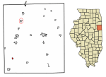 Location of Buckley in Iroquois County, Illinois | |
 Buckley Buckley's location in Iroquois County | |
| Coordinates: 40°35′49″N 88°02′17″W / 40.59694°N 88.03806°WCoordinates: 40°35′49″N 88°02′17″W / 40.59694°N 88.03806°W | |
| Country |
|
| State |
|
| County | Iroquois |
| Township | Artesia |
| Government | |
| • Mayor | Odin Koch |
| • Chief of Police | James Koch |
| Area[1] | |
| • Total | 0.34 sq mi (0.89 km2) |
| • Land | 0.34 sq mi (0.87 km2) |
| • Water | 0.01 sq mi (0.01 km2) |
| Elevation | 702 ft (214 m) |
| Population (2010) | |
| • Total | 600 |
| • Estimate (2016)[2] | 560 |
| • Density | 1,661.72/sq mi (640.77/km2) |
| ZIP code | 60918 |
| Area code(s) | 217 |
| FIPS code | 17-09317 |
Buckley is a village in Artesia Township, Iroquois County, Illinois, United States. The population was 600 at the 2010 census.[3]
Geography
Buckley is located in southwestern Iroquois County at 40°35′50″N 88°2′13″W / 40.59722°N 88.03694°W (40.597236, -88.037019).[4] U.S. Route 45 passes through the village, leading north 8 miles (13 km) to Onarga and south 6 miles (10 km) to Loda. Interstate 57 passes 1 mile (2 km) west of Buckley, with access from Exit 272. I-57 leads north 38 miles (61 km) to Kankakee and south 36 miles (58 km) to Champaign.
According to the 2010 census, Buckley has a total area of 0.346 square miles (0.90 km2), of which 0.34 square miles (0.88 km2) (or 98.27%) is land and 0.006 square miles (0.02 km2) (or 1.73%) is water.[5]
Buckley celebrated its Sesquicentennial in 2006.
Demographics
| Historical population | |||
|---|---|---|---|
| Census | Pop. | %± | |
| 1880 | 324 | — | |
| 1890 | 433 | 33.6% | |
| 1900 | 490 | 13.2% | |
| 1910 | 495 | 1.0% | |
| 1920 | 461 | −6.9% | |
| 1930 | 485 | 5.2% | |
| 1940 | 457 | −5.8% | |
| 1950 | 554 | 21.2% | |
| 1960 | 690 | 24.5% | |
| 1970 | 680 | −1.4% | |
| 1980 | 604 | −11.2% | |
| 1990 | 557 | −7.8% | |
| 2000 | 593 | 6.5% | |
| 2010 | 600 | 1.2% | |
| Est. 2016 | 560 | [2] | −6.7% |
| U.S. Decennial Census[6] | |||
As of the census[7] of 2000, there were 593 people, 261 households, and 171 families residing in the village. The population density was 1,721.1 people per square mile (673.4/km²). There were 285 housing units at an average density of 827.2 per square mile (323.6/km²). The racial makeup of the village was 97.47% White, 0.17% African American, 0.17% Asian, 2.02% from other races, and 0.17% from two or more races. Hispanic or Latino of any race were 3.37% of the population.
There were 261 households out of which 28.4% had children under the age of 18 living with them, 55.6% were married couples living together, 8.8% had a female householder with no husband present, and 34.1% were non-families. 32.6% of all households were made up of individuals and 18.0% had someone living alone who was 65 years of age or older. The average household size was 2.27 and the average family size was 2.84.
In the village, the population was spread out with 23.6% under the age of 18, 6.2% from 18 to 24, 28.0% from 25 to 44, 18.0% from 45 to 64, and 24.1% who were 65 years of age or older. The median age was 40 years. For every 100 females, there were 97.0 males. For every 100 females age 18 and over, there were 97.0 males.
The median income for a household in the village was $35,781, and the median income for a family was $48,250. Males had a median income of $31,458 versus $21,719 for females. The per capita income for the village was $21,251. About 5.4% of families and 5.3% of the population were below the poverty line, including 6.7% of those under age 18 and 6.3% of those age 65 or over.
Details
Buckley contains two schools. One is St. John's Lutheran School, which has 8 grades. At last report, there was 100 percent enrollment of the children from the church families. The present building was built in 1955-56 and is the fourth school building for the congregation. A building program is underway to expand.
The congregation owns a cemetery east and south of the town, separated from the township cemetery (Woodland Cemetery) only by a driveway and stand of trees. The eastern boundary of both cemeteries is marked by the course of Spring Creek.
Christ Lutheran High School inhabits a building west of the Illinois Central Railroad tracks which was originally Buckley High School, then Buckley-Loda-High School until further consolidation, which moved the public high school to Paxton, in Ford County, as Paxton-Buckley-Loda High School. The building remained empty until the successful formation of an association of Lutheran congregations in towns of the surrounding area.
References
- ↑ "2016 U.S. Gazetteer Files". United States Census Bureau. Retrieved Jun 29, 2017.
- 1 2 "Population and Housing Unit Estimates". Retrieved June 9, 2017.
- ↑ "Geographic Identifiers: 2010 Census Summary File 1 (G001): Buckley village, Illinois". American Factfinder. U.S. Census Bureau. Retrieved March 27, 2018.
- ↑ "US Gazetteer files: 2010, 2000, and 1990". United States Census Bureau. 2011-02-12. Retrieved 2011-04-23.
- ↑ "G001 - Geographic Identifiers - 2010 Census Summary File 1". United States Census Bureau. Retrieved 2015-08-02.
- ↑ "Census of Population and Housing". Census.gov. Archived from the original on May 12, 2015. Retrieved June 4, 2015.
- ↑ "American FactFinder". United States Census Bureau. Archived from the original on 2013-09-11. Retrieved 2008-01-31.
Municipalities and communities of Iroquois County, Illinois, United States | ||
|---|---|---|
| Cities | ||
| Villages | ||
| Townships | ||
| Unincorporated communities | ||
| Footnotes | ‡This populated place also has portions in an adjacent county or counties | |