Bubiyan Island
| Native name: جزيرة بوبيان | |
|---|---|
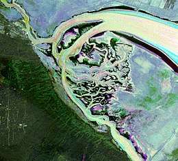 False-color satellite image of Kuwaiti islands at the northwest corner of the Persian Gulf. Bubiyan is the light-blue mass taking up most of the right side of the image. | |
 Location of Bubiyan Island in Kuwait | |
| Geography | |
| Location | Persian Gulf |
| Coordinates | 29°47′N 48°11′E / 29.783°N 48.183°ECoordinates: 29°47′N 48°11′E / 29.783°N 48.183°E |
| Area | 863 km2 (333 sq mi) |
| Length | 40 km (25 mi) |
| Width | 24 km (14.9 mi) |
| Administration | |
| Demographics | |
| Population | uninhabited |
| Designations | |
|---|---|
| Official name | Mubarak Al-Kabeer Reserve |
| Designated | 5 September 2015 |
| Reference no. | 2239[1] |
Bubiyan Island (Arabic: جزيرة بوبيان) is the largest island in the Kuwaiti coastal island chain situated in the north-western corner of the Persian Gulf, with an area of 863 km2 (333 sq mi). The island is uninhabited.
The island is mostly flat and low, salt marshes cover most of the coast. There are some intermittent wadis in the center of the island.[2]
It is separated from the Iraqi mainland in the northeast by the Al-Zubayr channel and from the Kuwaiti mainland in the southwest by the Al-Sabiyyah channel.[2] The latter channel trends around the northern end of Bubiyan Island, separating it from Warbah Island. 5.4 km (3 mi) northwest of Ras al Barshah, the southernmost point, Bubiyan is linked to the mainland by a concrete girder bridge over the Khawr as Sabiyah channel, 2.38 km (1.48 mi)[3] long, built in 1981-1983 and opened February 1983[4], which is for military use only.
During the Gulf War of 1991, four spans of the bridge were destroyed; they have been rebuilt in 1999[5]. The island itself was converted to a military base in 1991 and has served as one ever since.[6]In November 1994, Iraq formally accepted the UN-demarcated border with Kuwait which had been spelled out in Security Council Resolutions 687 (1991), 773 (1992), and 833 (1993) which formally ended an earlier claim to Bubiyan Island.[7]
In response to Kuwait becoming the 169th signatory of the Ramsar Convention, the Mubarak al-Kabeer reserve was designated as the country's first Wetland of International Importance. The 50,948 hectare reserve consists of small lagoons and shallow salt marshes and is important as a stop-over for migrating birds on two migration routes; Turkey to India and Eurasia to Africa. Breeding water-birds include the world's largest breeding colony of Crab-plover (Dromas ardeola), and the surrounding sea is major nursery for many commercial fish species.[8]
References
- ↑ "Mubarak Al-Kabeer Reserve". Ramsar Sites Information Service. Retrieved 25 April 2018.
- 1 2 "Bubiyan | island, Kuwait". Encyclopedia Britannica. Retrieved 2017-08-06.
- ↑ Bubiyan Bridge at Structurae
- ↑ http://www.crbc.com/site/crbcEN/signature/info/2013/1368.html
- ↑ p.9
- ↑ "Kuwait Geography and Population". Retrieved 14 March 2012.
- ↑ "CIA World Fact Book - Iraq". everything2.com. 2007-01-14.
- ↑ Ramsar. "Kuiwait becomes Ramsar state". BirdGuides. Retrieved 7 September 2015.
External links
- "Nautical description" (PDF). (607 KiB)
| Inhabited islands | |
|---|---|
| Uninhabited islands | |