Brule (CDP), Wisconsin
| Brule, Wisconsin | |
|---|---|
| Census-designated place | |
 Brule | |
| Coordinates: 46°33′11″N 91°34′36″W / 46.55306°N 91.57667°WCoordinates: 46°33′11″N 91°34′36″W / 46.55306°N 91.57667°W | |
| Country | United States |
| State | Wisconsin |
| County | Douglas |
| Town | Brule |
| Area | |
| • Total | 2.677 sq mi (6.93 km2) |
| • Land | 2.677 sq mi (6.93 km2) |
| • Water | 0 sq mi (0 km2) |
| Elevation | 988 ft (301 m) |
| Population (2010) | |
| • Total | 254 |
| • Density | 95/sq mi (37/km2) |
| Time zone | UTC-6 (Central (CST)) |
| • Summer (DST) | UTC-5 (CDT) |
| ZIP code | 54820 |
| Area code(s) | 715 and 534 |
| GNIS feature ID | 1562290[1] |
Brule is an unincorporated, census-designated place; located in the town of Brule, Douglas County, Wisconsin, United States.
U.S. Highway 2 serves as a main route in the community.
Brule is located 6.5 miles east-northeast of Lake Nebagamon; 30 miles east of the city of Superior; and 35 miles west of the city of Ashland.
As of the 2010 census, its population was 254.[2]
Brule has a post office with ZIP code 54820.[3]
References
- ↑ U.S. Geological Survey Geographic Names Information System: Brule (CDP), Wisconsin
- ↑ "American FactFinder". U.S. Census Bureau. Retrieved 29 March 2011.
- ↑ ZIP Code Lookup Archived June 15, 2011, at the Wayback Machine.
Municipalities and communities of Douglas County, Wisconsin, United States | ||
|---|---|---|
| City | 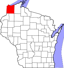 | |
| Villages | ||
| Towns | ||
| CDPs | ||
| Unincorporated communities |
| |
| Indian reservation | ||
| Footnotes | ‡This populated place also has portions in an adjacent county or counties | |
This article is issued from
Wikipedia.
The text is licensed under Creative Commons - Attribution - Sharealike.
Additional terms may apply for the media files.