Bruin, Kentucky
| Bruin, Kentucky | |
|---|---|
| Unincorporated community | |
 Bruin Location within the state of Kentucky  Bruin Bruin (the US) | |
| Coordinates: 38°10′30″N 83°1′32″W / 38.17500°N 83.02556°WCoordinates: 38°10′30″N 83°1′32″W / 38.17500°N 83.02556°W | |
| Country | United States |
| State | Kentucky |
| County | Elliott |
| Elevation | 689 ft (210 m) |
| Time zone | UTC-5 (Eastern (EST)) |
| • Summer (DST) | UTC-4 (EDT) |
| ZIP codes | 41125 |
| GNIS feature ID | 507598 |
Bruin is an unincorporated community in Elliott County, Kentucky, United States. It lies along Routes 7 and 409 just south of Grayson Lake State Park. Bruin is northeast of the county seat, Sandy Hook.[1] Its elevation is 689 feet (210 m).[2]
The post office was established on 28 December 1869 by Samuel Mobley[1] The community was named after Bruin Creek[1] which flows parallel to Route 7 on the east side.[3]
References
- 1 2 3 Rennick, Robert M. (1987) Kentucky Place Names University Press of Kentucky, Lexington, Kentucky, p. 39, ISBN 0-8131-0179-4
- ↑ U.S. Geological Survey Geographic Names Information System: Bruin, Kentucky, Geographic Names Information System, 1979-09-20. Accessed 2008-01-03.
- ↑ Bruin Quadrangle, Kentucky, (1971) Topographic Map 1:24,000, United States Geological Survey
External links
Municipalities and communities of Elliott County, Kentucky, United States | ||
|---|---|---|
| City | 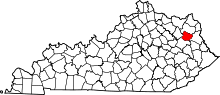 | |
| Unincorporated communities | ||
This article is issued from
Wikipedia.
The text is licensed under Creative Commons - Attribution - Sharealike.
Additional terms may apply for the media files.