Brown ocean effect
The brown ocean effect is an observed weather phenomenon involving tropical cyclones after landfall. They are commonly expected to lose energy when they make landfall, but instead maintain strength or intensify over land surfaces.[1] While these systems are highly common in the United States and China, the National Oceanic and Atmospheric Administration (NOAA) names Australia the most conducive environment after 30 years of research. In Australia, such storm systems are called agukabams.[2]
Background
One source of the brown ocean effect has been identified as the large amount of latent heat that can be released from extremely wet soils.[1][1][3][4] A 2013 NASA study found that, from 1979-2008, 45 of 227 tropical storms either gained or maintained strength after making landfall.[5] The press release stated, "The land essentially mimics the moisture-rich environment of the ocean, where the storm originated." Originally, research devoted to extratropical cyclones, storms that first derive energy from the warm ocean waters and later from the conjecture of various air masses, explained the intensification of storms after landfall.[6] However, as research into these storms persists, Andersen and Shepherd, the two leading scientists behind the NASA study, discovered that some of these storms were not transitioning from warm-core to cold-core but were actually maintaining their warm-core dynamics, while ultimately outputting a greater measure of rainfall.[6]
In order for the brown ocean effect to take place, three land conditions must be met: "First, the lower level of the atmosphere mimics a tropical atmosphere with minimal variation in temperature. Second, soils in the vicinity of the storms need to contain ample moisture. Finally, evaporation of the soil moisture releases latent heat, which the team found must measure at least 70 watts averaged per square meter."[6] Storm systems impacted by the brown ocean effect gave rise to a new sub-category of tropical storm type called Tropical Cyclone Maintenance and Intensification Event or TCMI.[6] Another study concluded that latent surface heat flux from land surfaces actually have the potential to be larger than from the ocean, albeit for brief periods only.[7] Andersen and Shepherd are also examining the effects of climate change on TCMIs, looking into the potential intensification of these storms due to increase or decrease in the degree of wetness and dryness in areas susceptible to these systems.[6]
Examples
2001's Tropical Storm Allison spent a dozen days in June meandering slowly across the Southeastern United States from Texas to the Carolinas, generating torrential rains and looking much healthier over land than it would over the ocean prior to landfall and subsequent of departure.
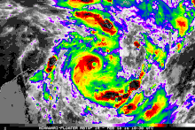
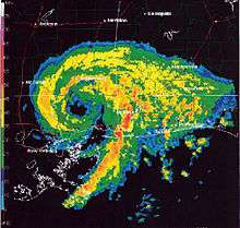
Tropical Storm Erin of 2007 is an example of the effect, when the storm intensified over central Texas, eventually forming an eye over Oklahoma.[1][3][4] Tropical Storm Erin gained even more traction as it travelled across the plains, a rare feat as most tropical storms weaken as they go farther inland.[4] Andersen states "Until events like Erin in 2007, there was not much focus on post-landfall tropical cyclones unless they transitioned. Erin really brought attention to the inland intensification of tropical cyclones."[6]
Tropical Storm Fay (2008) upon landfall over the Florida mainland strengthened to near hurricane strength and briefly forming an eye-like feature before weakening. The cause of this was the waterlogged terrain of South Florida specifically Lake Okeechobee and the Everglades.[8]
Another possible case is Tropical Storm Bill of 2015, when saturated soil conditions sustained the system for a longer period of time.[9]
In 2016, Tropical Depression Eleven made landfall in Eastern Florida. While over land, it became the first tropical cyclone to reach tropical storm strength while over Florida, where it was named Julia.
One possible case in the southern hemisphere is Tropical Cyclone Kelvin in 2018. Shortly after making landfall over Western Australia, Kelvin developed a clear eye and continued strengthening despite moving over the Great Sandy Desert, where most tropical cyclones rapidly weaken.
Subtropical Storm Alberto of 2018 is another example of the brown ocean effect. Two days after developing into a subtropical cyclone over the Gulf of Mexico, Alberto made landfall over Florida. The storm became more organized after landfall, transitioning from a subtropical to a tropical cyclone as it traversed land, lasting for an additional three days after its landfall. Alberto became one of only eleven cyclones to reach Lake Huron as a tropical depression.[10]
References
- 1 2 3 4 Jeff Masters and Bob Henson (15 June 2015). "Dangerous Flood Potential in Texas, Oklahoma from Invest 91L".
- ↑ Kerry Emanuel, Jeff Callaghan, and Peter Otto (2008). "A Hypothesis for the Redevelopment of Warm-Core Cyclones over Northern Australia". Bibcode:2008MWRv..136.3863E. doi:10.1175/2008MWR2409.1.
- 1 2 Clark Evans, Russ S. Schumacher, and Thomas J. Galarneau Jr. (2011). "Sensitivity in the Overland Reintensification of Tropical Cyclone Erin (2007) to Near-Surface Soil Moisture Characteristics". Bibcode:2011MWRv..139.3848E. doi:10.1175/2011MWR3593.1.
- 1 2 3 "How 'Brown Oceans' Fuel Hurricanes". LiveScience.com. Retrieved 2016-03-01.
- ↑ "Abundant soil moisture could trigger 'brown ocean' effect, strengthen storm as it moves inland | Fox News". Fox News. 2015-06-15. Retrieved 2016-03-01.
- 1 2 3 4 5 6 Kathryn Hansen (2013). "'Brown Ocean' Can Fuel Inland Tropical Cyclones". NASA.
- ↑ Theresa K. Andersen, David E. Radcliffe, and J. Marshall Shepherd (2013). "Quantifying Surface Energy Fluxes in the Vicinity of Inland-Tracking Tropical Cyclones". Bibcode:2013JApMC..52.2797A. doi:10.1175/JAMC-D-13-035.1.
- ↑
- ↑ Bob Henson (22 June 2015). "Long-Lived Bill Meets its Demise in Mid-Atlantic".
- ↑ Wenckstern, Erin. "The strangeness of Alberto: Making history over Great Lakes". The Weather Network. Retrieved 1 June 2018.