Brookhaven Historic District
|
Brookhaven Historic District | |
 | |
| Location | E of Peachtree-Dunwoody Rd. and N and E of Peachtree Rd., Atlanta, Georgia |
|---|---|
| Coordinates | 33°51′49″N 84°21′02″W / 33.86361°N 84.35056°WCoordinates: 33°51′49″N 84°21′02″W / 33.86361°N 84.35056°W |
| Area | 300 acres (120 ha) |
| Built | 1910 |
| Architectural style | Late 19th And 20th Century Revivals |
| NRHP reference # | 86000134[1] |
| Added to NRHP | January 24, 1986 |
The Brookhaven Historic District in Atlanta, Georgia is a 300 acres (120 ha) historic district which was listed on the National Register of Historic Places in 1986. The listing included 202 contributing buildings and two contributing structures.[1]
It is located east of Peachtree-Dunwoody Road and north and east of Peachtree Road. It spans across the border of DeKalb County and Fulton County.[1][2]
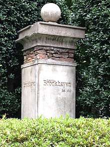
Marker
It is a residential area laid out and developed beginning in 1910.[2]
References
- 1 2 3 National Park Service (2013-11-02). "National Register Information System". National Register of Historic Places. National Park Service.
- 1 2 Carolyn Brooks (December 5, 1985). "National Register of Historic Places Inventory/Nomination: Brookhaven Historic District". National Park Service. Retrieved May 29, 2018. With accompanying 60 photos from 1985
| Topics | |
|---|---|
| Lists by states |
|
| Lists by insular areas | |
| Lists by associated states | |
| Other areas | |
| |
This article is issued from
Wikipedia.
The text is licensed under Creative Commons - Attribution - Sharealike.
Additional terms may apply for the media files.