Bristol Built-up Area
| Bristol Built-Up Area | |
|---|---|
| Conurbation | |
| Sovereign state | United Kingdom |
| Constituent country | England |
| Largest settlements |
(Pop. 100,000+)
|
| Area | |
| • Total | 55.76 sq mi (144.42 km2) |
| Population (2015 estimate) | |
| • Total | 724,000 [1] |
| • Rank | 8th |
| • Density | 11,636/sq mi (4,492.6/km2) |
| Time zone | UTC+0 (GMT) |
| • Summer (DST) | UTC+1 (BST) |
| Postcode | BS |
| Area code(s) | 0117, 01275, 01454 |
The Bristol Built-Up Area is a term used by the Office for National Statistics (ONS) to refer to a conurbation in based around the city of Bristol, in South West England. It was formerly known as the Bristol Urban Area. It is the 7th largest urban area in England and 8th largest in the United Kingdom. It covers the contiguous built-up area around Bristol, including the Kingswood, Mangotsfield, Stoke Gifford, Bradley Stoke, Patchway, Filton, Almondsbury, Frampton Cotterell and Winterbourne areas within South Gloucestershire; Pill and Easton-in-Gordano within North Somerset; and part of Whitchurch which falls within the administrative area of Bath and North East Somerset.[2]
Subdivisions
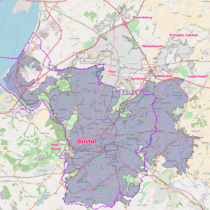
Bristol Built-up Area and its urban subdivisions in 2011
Bristol subdivision
Other subdivisions
City of Bristol unitary authority boundary
| Urban subdivision | Population Census 2011 |
|---|---|
| Bristol | 535,907 |
| Filton | 59,495 |
| Frampton Cotterell & Winterbourne | 14,694 |
| Pill | 4,828 |
| Almondsbury | 855 |
| Leigh Woods | 553 |
| Whiteshill | 403 |
| Hambrook | 349 |
| Coalpit Heath | 196 |
| Total | 617,280 |
See also
References
This article is issued from
Wikipedia.
The text is licensed under Creative Commons - Attribution - Sharealike.
Additional terms may apply for the media files.