Brigelser Hörner
| Brigelser Hörner | |
|---|---|
 | |
| Highest point | |
| Peak | Cavistrau Grond |
| Elevation | 3,251 m (10,666 ft) |
| Prominence | 448 m (1,470 ft) [1] |
| Parent peak | Tödi |
| Coordinates | 46°47′4.1″N 8°58′25.8″E / 46.784472°N 8.973833°ECoordinates: 46°47′4.1″N 8°58′25.8″E / 46.784472°N 8.973833°E |
| Geography | |
 Brigelser Hörner Location in Switzerland | |
| Location | Graubünden |
| Country | Switzerland |
| Parent range | Glarus Alps |
| Topo map | Swiss Federal Office of Topography swisstopo |
| Climbing | |
| First ascent | 19 July 1865 by Rudolf Elmer [2] |
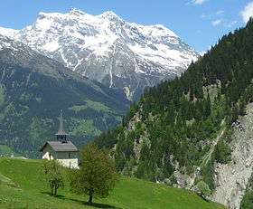
The Brigelser Hörner is a mountain massif in the Glarus Alps, and a range overlooking Breil/Brigels and Trun in canton of Graubünden. To its northern side above Val Frisal lies a nameless firn field. They are connected to the north by the saddle Barcun risal Sut (2,805 metres (9,203 ft)) with Piz Frisal and Piz Durschin at the border to canton of Glarus.
It consists of the following peaks, from west to east:
- Cap Grond, 3195 m
- Cavistrau Grond, 3251 m
- Cavistrau Pign, 3219 m
- Piz Tumpiv, 3100 m
In a broader sense, the following peaks are also part of the Hörner:
- Piz Dadens, 2772 m
- Piz Dado, 2698 m
References
- ↑ Swisstopo maps
- ↑ H. Dübi, Die Brigselhörner, Jahrbuch des Schweizer Alpenclub, Volume 29, pp. 315-322
This article is issued from
Wikipedia.
The text is licensed under Creative Commons - Attribution - Sharealike.
Additional terms may apply for the media files.