Branko's Bridge
| Branko's Bridge Бранков мост Brankov most | |
|---|---|
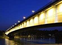 Branko's bridge at night | |
| Coordinates | 44°48′53″N 20°26′54″E / 44.8147°N 20.4483°ECoordinates: 44°48′53″N 20°26′54″E / 44.8147°N 20.4483°E |
| Official name |
Бранков мост Brankov most |
| Characteristics | |
| Total length | 450 m (1,480 ft) |
| Longest span | 261 m (856 ft) |
| History | |
| Opened | 1956 |
| Statistics | |
| Daily traffic | 90,000 vehicles |
Branko's bridge (Serbian: Бранков мост / Brankov most) is the second-largest bridge (after Gazela) of Belgrade, Serbia, connecting the city center with New Belgrade across Sava river.
Location
On the right (eastern) bank, the bridge starts at the Sava Port, above the Karađorđeva Street, central street in the neighborhood of Savamala. The bridge is an extension of the Brankova Street, which delineates it from the neighborhood of Kosančićev Venac on the north and Zeleni Venac on the south. Through the Terazije tunnel, the Brankova connects it directly to downtown. On the left (western) bank, the bridge enters New Belgrade between the neighborhoods of Staro Sajmište, on the south, and Ušće, on the north. It extends into the Bulevar Mihajla Pupina which, passing between the Ušće Tower and Hyatt Regency Belgrade Hotel, connects it with New Belgrade and continues to the neighborhood of Zemun.[1][2]
Name
Official name of the bridge during the communist rule was "Brotherhood and unity bridge" (Most bratstva i jedinstva), but that name never caught on. Citizens referred to it as the "Savski most" (Sava bridge), "Zemunski most" (Zemun bridge) and the "bridge in Branko's street", as the bridge is an extension of the Brankova street, named after Branko Radičević, Serbian romanticist poet. The latter name was colloquially shortened to Brankov most (Branko's bridge) and the name prevailed.[3] Urban myth is that the bridge got its name after the writer, Branko Ćopić, committed a suicide by jumping from the bridge in 1984.[4][5][6]
History
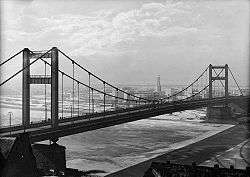
The bridge was built in 1956,[6] replacing the former chain-stayed King Alexander Bridge (built by the Société de Construction des Batignolles) that was opened on 16 December 1934 and blown up in 1941.[7] The bridge actually uses lower parts of the former bridge's pylons (decorated by Ivan Meštrović with two couples of reinforced concrete in Serbo-Byzantium style) as outer constraints for its two secondary spans.[6] It is 450 m (1,480 ft) long, made as continuous steel box girder, with central span of 261 m (856 ft) and side spans of 81 m (266 ft) each. It is crossed by nearly 90,000 vehicles daily, and traffic congestions are frequent.[8]
German company MAN is behind the original project of the bridge. Belgrade-based "Mostprojekt" company executed the project of doubling the bridge capacity in the 1970s. Head of the project team was Danilo Dragojević.[9] Since the works were finished in 1979, the bridge has dual carriageway with three lanes in both directions and actually consists of two separate constructions in each direction.[10]
In the Interbellum, the trams connected Belgrade to Zemun via King Alexander I bridge. After the war, in the 1950s, the general idea was that trolleybuses should take over the major role in the public transportation. Line to Zemun was opened in 1956, and in time three lines over the bridge were formed: Line 14 – Zeleni Venac-Gornji Grad (Zemun) (which was considered a successor line to the pre-war tram line), Line 15 – Zeleni Venac-Novi Grad (Zemun) and Line 16 – Zeleni Venac-Pohorska, New Belgrade. The lines were closed in 1973.[11] However, as of 2017, over 25 bus lines of public transport crosses the bridge.[10]


Present
The bridge gained an infamous reputation as the suicide bridge. Some 40 people try to commit suicide jumping of the Branko's Bridge every year.[6]
2010s reconstruction
In the summer of 2013, the left pedestrian and bicycle path began to show signs of deterioration. Soon, the path was completely closed. City government for several years ignored the protests of citizens who wanted for the path to be repaired and open again. The administration claimed that there are no funds in the budget and that it appears the path can't be simply repaired. Instead, the entire left side had to be completely renovated. In the summer of 2015, Mayor of Belgrade Siniša Mali announced that city will fix the problem but the tender was announced in October 2016 and in November the "Mostogradnja" company was chosen.[10]
In the late February 2017 a 210 million dinars (€1.75 million) contract was signed with "Mostogradnja". Mali claimed that the study was done in 2014 and that it showed the situation was worse than previously thought.[12] However, only in June 2017, Mali announced "preparatory works". Deadline was set at 260 days since the beginning of the "proper" works.[10] The repair began in early July 2017, four years after the path was closed, and the deadline was shortened to 180 days, but the mayor then shortened it even more, saying it will be finished by October or November 2017.[13]
Mali also announced that three shifts will be organized. Still in August, a month later, it was obvious that not much was happening on the bridge. Mali said that the city displaced the permit, but after the criticism, reconstruction was fastened. Mali announced new deadline, end of 2017, but few days later again changed it to 2-2,5 months. Despite the speedup, by October it was obvious that the bridge will not be finished by the end of the year. That same month, city manager Goran Vesić announced that the bridge will be completely finished by the end of March 2018, or the originally planned 9 months.[12] In the end, all lanes were open on 9 February 2018,[14], and, after five years, the works were fully finished and the pedestrian and bicycle path was open on 31 May 2018.[15]
See also
References
- ↑ Tamara Marinković-Radošević (2007). Beograd - plan i vodič. Belgrade: Geokarta. ISBN 86-459-0006-8.
- ↑ Beograd - plan grada. Smedrevska Palanka: M@gic M@p. 2006. ISBN 86-83501-53-1.
- ↑ Dejan Aleksić (3 May 2007). "Kad kreneš u Srpskih vladara, a prijatelj te čeka u Maršala Tita" (in Serbian). Politika.
- ↑ Z.Nikolić (9 October 2013). "Beogradske priče: Bezimeni Brankov most" (in Serbian). Večernje novosti.
- ↑ "Sporno ime mosta" (in Serbian). 21 February 2000.
- 1 2 3 4 M.Luković (8 July 2010), "„Gazelini regenti" preuzimaju dužnost", Politika (in Serbian)
- ↑ "Twentieth Century - Innovations in Belgrade (1930-1950)". Serbia-info.com. Archived from the original on 18 January 2008.
- ↑ "Cevovod na Brankovom mostu". Direkcija za građevinsko zemljište i izgradnju Beograda. 2 August 2006. Archived from the original on 29 September 2007.
- ↑ "Malo ih je, ali su značajni" (in Serbian). 14 January 2008.
- 1 2 3 4 Dejan Aleksić (14 June 2017), "Počinju pripremni radovi za obnovu leve trake", Politika (in Serbian), p. 16
- ↑ Dejan Aleksić (2 May 2017), "„Trole" vozile Novobeograđane i Zemunce", Politika (in Serbian), p. 31
- 1 2 Dejan Aleksić (25 October 2017), "Realan rok za završetak radova – proleće" [Realistic deadline for the end of works - spring], Politika (in Serbian)
- ↑ Dejan Aleksić (15 July 2017), "Pešaci i biciklisti obnovljenom stazom i pre zime", Politika (in Serbian), p. 14
- ↑ Dejan Aleksić (9 February 2018). "Од вечерас проходне све траке на Бранковом мосту" [All lanes on Branko's Bridge will be open tonight]. Politika (in Serbian). p. 14.
- ↑ Dejan Aleksić (1 June 2018). "Posle pet godina cela pešačka staza prohodna" [After five years, the entire pedestrian path is operational]. Politika (in Serbian).
External links
| Wikimedia Commons has media related to Branko's Bridge. |
- Fanovi "Stonsa" opasno zaljuljali Brankov most Blic, 17 July 2007
- Policija nije dala da večeraju na Brankovom mostu
| Bridges on the Sava | |
|---|---|
| Bridges on the Danube | |
| Former bridges |
|
Coordinates: 44°48′53″N 20°26′54″E / 44.81472°N 20.44833°E