Bradleyville, Missouri
| Bradleyville, Missouri | |
|---|---|
| Unincorporated community | |
 Bradleyville, Missouri Location of Bradleyville, Missouri | |
| Coordinates: 36°47′01″N 92°54′30″W / 36.78361°N 92.90833°WCoordinates: 36°47′01″N 92°54′30″W / 36.78361°N 92.90833°W[1] | |
| Country | United States |
| State | Missouri |
| County | Taney |
| Reincorporated | October 20, 2002[2] |
| Disincorporated | October 17, 2009[2] |
| Elevation[1] | 853 ft (260 m) |
| Population | |
| • Total | 80 |
| Time zone | UTC-6 (Central (CST)) |
| • Summer (DST) | UTC-5 (CDT) |
| ZIP code | 65614 |
| Area code(s) | 417 |
| GNIS feature ID | 0748992[1] |
Bradleyville is an unincorporated community in northeastern Taney County, Missouri, United States.[1] It is located at the intersection of Route 76 and Route 125 above the west bank of Beaver Creek.[3] Bradleyville is part of the Branson, Missouri Micropolitan Statistical Area.
| Historical population | |||
|---|---|---|---|
| Census | Pop. | %± | |
| 1920 | 56 | — | |
| 1930 | 41 | −26.8% | |
| 1940 | 60 | 46.3% | |
| 1950 | 69 | 15.0% | |
| 1960 | 91 | 31.9% | |
| 1970 | 92 | 1.1% | |
| [4] | |||
History
A post office called Bradleyville has been in operation since 1861.[5] The community has the name of the local Bradley family.[6] The community was listed on the Census Bureau as incorporated from 1920 to 1970.[4] Bradleyville reincorporated in 2002.[2] The village disincorporated in 2009.[2]
References
- 1 2 3 4 U.S. Geological Survey Geographic Names Information System: Bradleyville, Missouri
- 1 2 3 4 "Boundary Changes".
- ↑ Missouri Atlas & Gazetteer, DeLorme, 1998, First edition, p. 62-3, ISBN 0-89933-224-2
- 1 2 "U.S. Decennial Census".
- ↑ "Post Offices". Jim Forte Postal History. Retrieved 27 December 2016.
- ↑ "Taney County Place Names, 1928–1945". The State Historical Society of Missouri. Archived from the original on June 24, 2016. Retrieved December 27, 2016.
Municipalities and communities of Taney County, Missouri, United States | ||
|---|---|---|
| Cities | 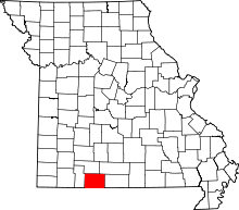 | |
| Villages | ||
| Townships | ||
| CDP | ||
| Other unincorporated communities | ||
| Ghost towns | ||
| Footnotes | ‡This populated place also has portions in an adjacent county or counties | |
This article is issued from
Wikipedia.
The text is licensed under Creative Commons - Attribution - Sharealike.
Additional terms may apply for the media files.