Bouse, Arizona
| Bouse, Arizona | |
|---|---|
| CDP | |
 | |
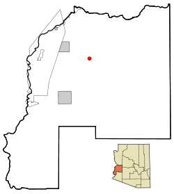 Location in La Paz County and the state of Arizona | |
 Bouse, Arizona Location in the United States | |
| Coordinates: 33°56′1″N 114°0′30″W / 33.93361°N 114.00833°WCoordinates: 33°56′1″N 114°0′30″W / 33.93361°N 114.00833°W | |
| Country | United States |
| State | Arizona |
| County | La Paz |
| Area[3] | |
| • Total | 136.22 sq mi (352.82 km2) |
| • Land | 136.22 sq mi (352.82 km2) |
| • Water | 0.00 sq mi (0.00 km2) |
| Elevation | 948 ft (289 m) |
| Population (2000) | |
| • Total | 730 |
| • Estimate (2016)[4] | N/A |
| Time zone | UTC-7 (MST (no daylight saving time)) |
| ZIP code | 85325 |
| Area code(s) | 928 |
| FIPS code | 04-07310 |
| GNIS feature ID | 0001887 |
Bouse (pronounced to rhyme with "house") is a census-designated place (CDP) in La Paz County, Arizona, United States. Founded in 1908 as a mining camp, the economy of Bouse is now based on tourism, agriculture and retirees.[5] The population was 996 at the 2010 census.
Geography
Bouse is located at 33°56′1″N 114°0′30″W / 33.93361°N 114.00833°W (33.933657, -114.008268).[6]
According to the United States Census Bureau, the CDP has a total area of 10.1 square miles (26 km2), all of it land.
Camp Bouse, 20 mi (32 km) east in Butler Valley, is the former site of a World War II US Army tank training camp. Although the buildings are gone, a few foundations remain, as do some of the tank tracks from World War II. There is a Camp Bouse memorial monument in Bouse.[7]
Demographics
| Historical population | |||
|---|---|---|---|
| Census | Pop. | %± | |
| U.S. Decennial Census[8] | |||
As of the census[9] of 2010, there were 996 people, 547 households, and 303 families residing in the CDP. The population density was 60.9 people per square mile (23.5/km²). There were 562 housing units at an average density of 55.7 per square mile (21.5/km²). The racial makeup of the CDP was 95.61% White, 0.33% Black or African American, 1.30% Native American, 0.16% Asian, 0.33% Pacific Islander, 0.81% from other races, and 1.46% from two or more races. Hispanic or Latino of any race were 4.55% of the population.
There were 320 households out of which 6.9% had children under the age of 18 living with them, 57.5% were married couples living together, 5.0% had a female householder with no husband present, and 35.3% were non-families. 30.3% of all households were made up of individuals and 22.2% had someone living alone who was 65 years of age or older. The average household size was 1.92 and the average family size was 2.33.
In the CDP, the population was spread out with 9.8% under the age of 18, 1.1% from 18 to 24, 8.5% from 25 to 44, 29.3% from 45 to 64, and 51.4% who were 65 years of age or older. The median age was 65 years. For every 100 females, there were 97.1 males. For every 100 females age 18 and over, there were 96.1 males.
The median income for a household in the CDP was $19,479, and the median income for a family was $27,935. Males had a median income of $36,250 versus $20,536 for females. The per capita income for the CDP was $13,623. About 9.9% of families and 21.0% of the population were below the poverty line, including 47.4% of those under age 18 and 12.3% of those age 65 or over.
Climate
This area has a large amount of sunshine year round due to its stable descending air and high pressure. According to the Köppen Climate Classification system, Bouse has a mild desert climate, abbreviated "Bwh" on climate maps.[10]
Economy
An egg facility owned by Rose Acre Farms broke ground near Bouse on July 13, 2015.[11] The facility was also planned to include a pullet farm, a rail spur from the Arizona and California Railroad, and a feed mill operation. According to the president of the La Paz Economic Development Corporation, it is the biggest economic development project ever taken in the county.[12] In early 2017, it was reported by the mayor of Parker that the facility has hens and its first truckload of eggs was out.[13]
See also
References
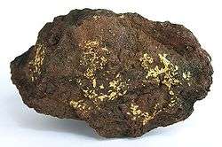
- ↑ "Dutchman Mine (Flying Dutchman Mine), Bouse, Plomosa District, Plomosa Mts, La Paz Co., Arizona, USA". www.mindat.org.
- ↑ "Dutchman Mine (Flying Dutchman Mine), Bouse, Plomosa District, Plomosa Mts, La Paz Co., Arizona, USA". www.mindat.org.
- ↑ "2016 U.S. Gazetteer Files". United States Census Bureau. Retrieved Jul 18, 2017.
- ↑ "Population and Housing Unit Estimates". Retrieved June 9, 2017.
- ↑ Bouse community profile Archived September 16, 2009, at the Wayback Machine. at Arizona Department of Commerce
- ↑ "US Gazetteer files: 2010, 2000, and 1990". United States Census Bureau. 2011-02-12. Retrieved 2011-04-23.
- ↑ Camp Bouse information at Ghosttowns.com
- ↑ "Census of Population and Housing". Census.gov. Retrieved June 4, 2016.
- ↑ "American FactFinder". United States Census Bureau. Archived from the original on 2013-09-11. Retrieved 2008-01-31.
- ↑ "Bouse, Arizona Köppen Climate Classification (Weatherbase)". Weatherbase.
- ↑ Gutekunst, John (2015-07-17). "Rose Acre Farms holds groundbreaking ceremony". Parker Pioneer. Retrieved 2017-04-22.
- ↑ Gutekunst, John (2015-11-18). "Rose Acre Farms Reports Progress". Parker Pioneer. Retrieved 2017-04-22.
- ↑ Gutekunst, John (2017-04-11). "New police manual tabled". Parker Pioneer. Retrieved 2017-04-22.
External links
| Wikimedia Commons has media related to |
Municipalities and communities of La Paz County, Arizona, United States | ||
|---|---|---|
| Towns | 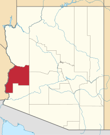 | |
| CDPs | ||
| Populated places | ||
| Indian reservations | ||
| Ghost towns | ||