Bou Craa
| Bou Craa بوكراع ⴱⵓⴽⵔⴰⵄ Bu Craa | |
|---|---|
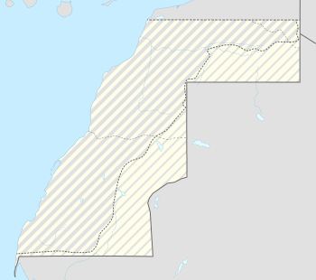 Bou Craa Location in Western Sahara | |
| Coordinates: 26°19′22″N 12°50′59″W / 26.32278°N 12.84972°W | |
| Country |
Western Sahara |
| Claimed by |
|
| Controlled by | Morocco |
Bou Craa (Bo Craa, Bu Craa, Boukra) (Arabic: بوكراع, Berber: ⴱⵓⴽⵔⴰⵄ) is a town in Western Sahara, south-east of the main city of El Aaiún. It is inhabited almost exclusively by employees of the Moroccan-controlled Bou Craa phosphate industry.
Located in the Saguia el-Hamra region, Bou Craa is the site of a phosphate deposit of 1.7 billion tons. Mining began there in 1972.[1] During the Spanish colonization time of the area (see Spanish Sahara), many early recruits of the nationalist movements Harakat Tahrir and Front Polisario were Sahrawi workers in the phosphate mines.
The town became part of the Moroccan-controlled zone in the April 1976 partition resulting from the Madrid Accords.[1] It has remained in Moroccan hands, though mining was halted in 1976 as a result of Polisario guerilla attacks. The phosphates are transported to the coast by an automated conveyor belt, the longest such belt in the world. During the Western Sahara War the Polisario vandalized and disabled this transportation system several times. These attacks gradually ceased in the early 1980s when the town become enclosed by the Moroccan Wall, which consolidated Moroccan control over the north-western part of Western Sahara (the so-called "Useful Triangle"[2]). Mining resumed on a reduced scale in July 1982.[1]
Today, the mine produces around 3 million tonnes annually, which represents 10% of Morocco's total production.[3]
Twin towns
Satellite images

- Low resolution view of the conveyor belt to the port at Laayoune-Plage. Its location can be seen from the line of windswept sand accumulating on its south-western side.
- The mines and tailings
- the start of the conveyor belt at the mine
References
- 1 2 3 Anthony G. Pazzanita; Tony Hodges (1994). "Bou-Craa". Historical Dictionary of Western Sahara. Scarecrow Press. p. 79. ISBN 978-0-8108-2661-8.
- ↑ <iframe frameborder="0" scrolling="no" style="border:0px" src="https://books.google.be/books?id=fgNjDgAAQBAJ&lpg=PT156&ots=XsiwlGKUiF&dq=western%20sahara%20%22useful%20triangle%22&pg=PT156&output=embed" width=500 height=500></iframe>
- ↑ WESTERN SAHARA: Bou Craa Phosphate Mine, BHP Billiton Watch, November 15, 2010.
Coordinates: 26°19′22″N 12°50′59″W / 26.32278°N 12.84972°W