Laayoune
| Laayoune العيون ⵍⵄⵢⵓⵏ El Aaiún | |
|---|---|
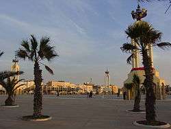 Plaza de la Marcha Verde | |
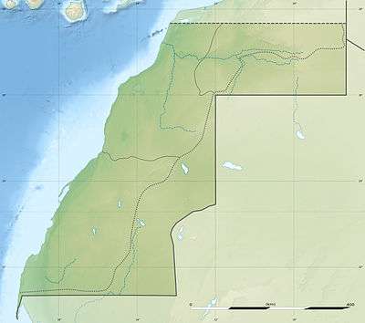 Laayoune Location in Western Sahara 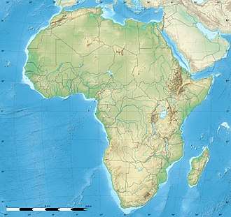 Laayoune Laayoune (Africa) | |
| Coordinates: 27°9′13″N 13°12′12″W / 27.15361°N 13.20333°WCoordinates: 27°9′13″N 13°12′12″W / 27.15361°N 13.20333°W | |
| Non-Self-Governing Territory | Western Sahara |
| Region | Laâyoune-Sakia El Hamra |
| Province | Laâyoune |
| Settled | 1934 |
| Founded | 1938 |
| Area | |
| • Total | 21 km2 (8 sq mi) |
| Population (2014)[1] | |
| • Total | 217,732 |
| Time zone | UTC |
Laayoune (Maghrebi Arabic: لعيون Al-ʿAyyūn/El-Aiun, Laʕyūn; Spanish: El Aaiún; French: Laâyoune; Berber: ⵍⵄⵢⵓⵏ, Leɛyun; Literary Arabic: العيون al-ʿuyūn, literally "The Springs") is the largest city of the disputed territory of Western Sahara currently administered by Morocco. The modern city is thought to have been founded by the Spanish colonizer Antonio de Oro in 1938.[2] In 1940, Spain designated it as the capital of the Spanish Sahara. Laâyoune (El-Aaiún) is the capital of the Laâyoune-Sakia El Hamra region administered by Morocco under the supervision of the UN peace-keeping mission in Western Sahara (MINURSO).
The town is divided in two by the dry river of Saguia el Hamra. On the south side is the old lower town, constructed by Spanish colonists. A cathedral from that era is still active; its priests serve this city and Dakhla further south.
History
Etymology
Laâyoune or El Aaiún are respectively the French and Spanish transliterations of the Maghrebi Arabic name Layoun which means "the water springs".
Geography
Climate
Laayoune has a mild desert climate, moderated by the Canary Current with an average annual temperature of 20 °C (68 °F).
| Climate data for Laayoune | |||||||||||||
|---|---|---|---|---|---|---|---|---|---|---|---|---|---|
| Month | Jan | Feb | Mar | Apr | May | Jun | Jul | Aug | Sep | Oct | Nov | Dec | Year |
| Average high °C (°F) | 22.0 (71.6) |
22.6 (72.7) |
23.7 (74.7) |
23.9 (75) |
25.4 (77.7) |
26.4 (79.5) |
28.8 (83.8) |
29.6 (85.3) |
29.2 (84.6) |
28.1 (82.6) |
25.0 (77) |
20.5 (68.9) |
25.4 (77.8) |
| Daily mean °C (°F) | 16.0 (60.8) |
16.7 (62.1) |
17.9 (64.2) |
18.6 (65.5) |
20.3 (68.5) |
21.4 (70.5) |
23.3 (73.9) |
23.9 (75) |
23.3 (73.9) |
22.3 (72.1) |
20.1 (68.2) |
15.4 (59.7) |
19.9 (67.9) |
| Average low °C (°F) | 10.0 (50) |
10.8 (51.4) |
12.2 (54) |
13.4 (56.1) |
15.2 (59.4) |
16.5 (61.7) |
17.9 (64.2) |
18.3 (64.9) |
17.4 (63.3) |
16.6 (61.9) |
15.3 (59.5) |
10.3 (50.5) |
14.5 (58.1) |
| Average rainfall mm (inches) | 3 (0.12) |
2 (0.08) |
1 (0.04) |
1 (0.04) |
0 (0) |
1 (0.04) |
0 (0) |
0 (0) |
0 (0) |
4 (0.16) |
7 (0.28) |
8 (0.31) |
27 (1.07) |
| Source: Climate-data.com [3] | |||||||||||||
Demographics
Laayoune has a population of 217,732[1] and is the largest city in Western Sahara. It is a growing economic hub.
Economy and status
The city is a hub for fishing and for phosphate mining in the region.[4] In 2010 the country was negotiating a new fishing agreement with Europe over offshore fishing.
Sport
The football club of the city is Jeunesse Massira. The club plays in the Moroccan Premier League, the highest football league in the country. Jeunesse Massira uses Stade Sheikh Mohamed Laghdaf for training and games.
Transport
Laayoune is served by Hassan I Airport.
Education
There is a Spanish international school, Colegio Español La Paz, owned by the Spanish government. It occupies a 17,000-square-metre (180,000 sq ft) property. In 2015 the parents' association, Asociación de Madres, Padres y Tutores de Alumnos del Colegio Español La Paz (AMPA), asked for the establishment of secondary education so their children would not have to go to Las Palmas or Morocco to continue their education.[5]
Gallery
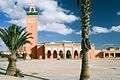 Mosque of Moulay Abd el Aziz
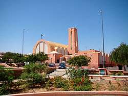 The old Spanish Cathedral of Saint Francis of Assisi, chiefly serves European UN personnel
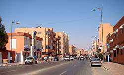 Avenue Makkah al-Mukarramah
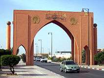 Monumental arch near the airport
Twin towns and sister cities
See also
References
- 1 2 "POPULATION LÉGALE DES RÉGIONS, PROVINCES, PRÉFECTURES, MUNICIPALITÉS, ARRONDISSEMENTS ET COMMUNES DU ROYAUME D'APRÈS LES RÉSULTATS DU RGPH 2014" (in Arabic and French). High Commission for Planning, Morocco. 8 April 2015. Retrieved 29 September 2017.
- ↑ Francisco López Barrios (2005-01-23). "El Lawrence de Arabia Español" (in Spanish). El Mundo. Retrieved 2013-02-11.
- ↑ "Climate: Laayoune".
- ↑ "Diplomacy over Western Sahara: 'Morocco v Algeria'", The Economist, 4 November 2010.
- ↑ Santana, Txema. "El colegio español en El Aaiún pide ciclo de secundaria" (Archive). El País. April 10, 2015. Retrieved on May 1, 2016. "Lagadaf Lahsen, presidente del AMPA del centro educativo, asegura que es “la única forma de evitar” que sus hijos “se vayan a otras ciudades de Marruecos o a Las Palmas de Gran Canaria, además de que no se pierda el español en el Sáhara”." and "[...]una instalación de 17.000 metros cuadrados que es propiedad del Estado español[...]"
- ↑ "Renewing the twining agreement between Central Algiers and Wilaya of El Aaiun". Sahara Press Service. 2011-10-30. Archived from the original on 2012-05-01. Retrieved 2011-11-02.
- ↑ Ayuntamiento de Almería (ed.). "Ciudades Hermanadas". Retrieved 2008-04-12.
- ↑ "Balance del viaje realizado por representantes municipales al Sahara". Aviles.es. Archived from the original on 2012-05-29. Retrieved 2011-09-04.
- ↑ Ayuntamiento de Málaga (ed.). "Official website for Malaga's candidature for European capital of culture in 2016". Archived from the original on 2009-03-22. Retrieved 2008-04-02.
- ↑ "Hermanamiento de Montevideo y El Aaiún". Montevideo.gub.uy. 2009-12-13. Archived from the original on 2012-12-02. Retrieved 2011-09-04.
- ↑ "El Ayuntamiento de Lorca denuncia la agresión de Marruecos contra el Pueblo Saharaui" (in Spanish). Murcia.es. 2010-11-12. Retrieved 2013-02-11.
External links
Capital: Laâyoune | ||
| Provinces | 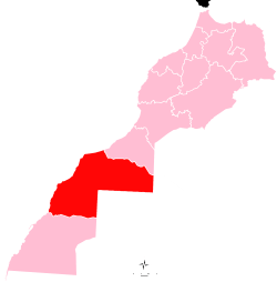 | |
| Municipalities | ||