Washington State Route 527
| ||||
|---|---|---|---|---|
| Bothell–Everett Highway | ||||
|
A map of southwest Snohomish County with SR 527 highlighted in red | ||||
| Route information | ||||
| Auxiliary route of I-5 | ||||
| Defined by RCW 47.17.745 | ||||
| Maintained by WSDOT | ||||
| Length | 9.29 mi[1] (14.95 km) | |||
| Existed | 1964–present | |||
| Major junctions | ||||
| South end |
| |||
| North end |
| |||
| Highway system | ||||
| ||||

State Route 527 (SR 527, also known as the Bothell–Everett Highway) is a state highway in Snohomish County, Washington. It travels north–south for 9 miles (14 km), connecting the Seattle suburbs of Bothell, Mill Creek, and Everett. The highway intersects several regional highways, including Interstate 405 (I-405) at its southern terminus, SR 96 in northern Mill Creek, and I-5 at an interchange with SR 99 and SR 526 in Everett.
The Bothell–Everett Highway was built in the 1910s as part of the intercity Pacific Highway and briefly formed part of U.S. Route 99 until the opening of modern-day SR 99 in 1927. The highway was signed by the state as Secondary State Highway 2A (SSH 2A) from 1937 to 1943 and SSH 2J from 1957 to 1964, when it was renumbered as SR 527.
Since its opening, nearby suburban development has contributed to traffic congestion on stretches of SR 527. During the 1990s and early 2000s, the state government widened the highway to its present four-lane configuration and added sidewalks, bus pullouts, and bicycle lanes. The southernmost 2.5 miles (4.0 km) of the highway, from SR 522 to I-405, was transferred to the Bothell city government in 2011 and decommissioned from the state highway system.
Route description
SR 527 begins as a continuation of the Bothell–Everett Highway at a partial cloverleaf interchange with I-405 in northern Bothell. The interchange is located adjacent to the Canyon Park park and ride, a major bus transfer facility. The highway travels northeast through the Canyon Park business park and turns north after crossing North Creek, following it to a junction with SR 524 at Thrasher's Corner.[2] SR 527 then crosses into the unincorporated North Creek area, which is filled with suburban homes and apartment complexes that line the road,[3] along with commercial areas at Kennard Corner and near North Creek County Park.[4][5]
The highway continues north into the center of Mill Creek at a junction with 164th Street Southeast. Through central Mill Creek, SR 527 forms the border between the Mill Creek Town Center, a linear shopping center to the west along North Creek, and the city's suburban neighborhoods to the east.[6][7] Near Henry M. Jackson High School, the highway turns northeast and intersects SR 96 at Murphy's Corner, located at the southern city limit of Everett.[5] The intersection has limited turns due to the steep angle at which SR 527 enters from the south, with an auxiliary street to the west used for the remaining movements to southbound SR 527.[4]
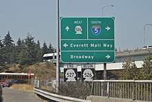
Following the junction, SR 527 curves westerly along the shore of Silver Lake, passing two small parks. After briefly traveling west along the lake's side, the highway continues north on 19th Avenue Southeast and passes through a commercial district that is bordered to the west by I-5. Near the Eastmont park and ride, SR 527 intersects I-5 and crosses over the freeway to its terminus, a junction with SR 99, Broadway, and part of SR 526 (the Boeing Freeway).[4][8] The highways connect SR 527 to Downtown Everett, the Everett Mall area, and the Boeing Assembly Plant, respectively.[5]
SR 527 is maintained by the Washington State Department of Transportation (WSDOT), which conducts an annual survey on state highways to measure traffic volume in terms of average annual daily traffic. Average traffic volumes on the highway in 2016 ranged from a minimum of 19,000 vehicles in northern Mill Creek to a maximum of 54,000 vehicles at the I-405 interchange.[9] The entire route is designated as part of the National Highway System, a network of roads identified as important to the national economy, defense, and mobility.[10][11] The corridor is also served by buses operated by Everett Transit and Community Transit,[12][13] and is planned to be used by Community Transit's Swift Green Line when it begins service in 2019.[14]
History
An early wagon road along North Creek between Bothell and Lowell (now part of Everett) was built in the late 19th century by local settlers and the county government.[15] The road was graded and improved with a permanent (but unpaved) surface in the early 1910s using funds allocated by the state government.[16] It was incorporated into the state highway system in 1913 as part of the Pacific Highway,[17] the primary cross-state route in Western Washington.[18] The Bothell–Everett portion of the highway was paved with concrete in 1916, following a bond issue for improved roads approved by Snohomish County voters the year prior.[19]
The Pacific Highway, later numbered to State Road 1 in 1923 and part of U.S. Route 99 (US 99) in 1926,[20][21] remained on the Bothell route until the completion of a straighter north–south highway to the west in 1927.[22][23] The Bothell–Everett highway was incorporated into part of Secondary State Highway 2A (SSH 2A) in 1937, forming a continuous route between Renton and Everett via the Eastside.[24] SSH 2A was later truncated to Bothell in 1943, removing the Snohomish County section, but it was returned to the state highway system in 1957 as the newly-created SSH 2J.[25][26] SSH 2J was renumbered to SR 527 in 1964 as part of a new numbering system implemented by the state government, which today forms the modern state highway system.[27] The highway's interchange with I-405 was completed and opened to traffic in November 1969.[28]
Major suburban development in the Mill Creek area began in the 1970s and contributed to growing traffic congestion on SR 527,[6] leading eventually to development moratoriums as temporary measures to quell growth.[29][30] The northernmost section of the highway, in Everett between 112th Street and the Broadway Interchange, was expanded to five lanes in the late 1970s using city funding, while the rest remained two lanes wide.[18][31] In 1980, the state department of transportation began preliminary planning for a wide-scale project to widen the highway to five lanes (including a center turn lane and sidewalks) in 1980.[18][31] The state legislature funded the widening project in 1990 with proceeds from a statewide gas tax increase, which coincided with the end of the development moratorium.[32]
The first phase of the project, from 228th Street near Canyon Park to 208th Street at Thrashers Corner, was completed in 1991 at a cost of $5.6 million.[33] Construction of the second phase, between Thrashers Corner and 164th Street in Mill Creek, was delayed by concerns that stormwater runoff would be inadequately handled by the new road.[34] It began construction in 1993 and was completed four years later at a cost of $18.8 million.[18] The City of Bothell also began its own widening project on a stretch of the highway south of Canyon Park in 1998, having decided against rerouting SR 527 onto a new bypass of the city center.[35][36]
The third phase of the state's widening project, between 164th Street and 132nd Street, was constructed from 2003 to 2004 and cost $27.8 million.[18] The project included new bicycle lanes along the curb of the highway, as well as decorated sound walls.[37] The fourth and final phase, from 132nd Street to 112th Street, was completed in May 2006 and cost $21 million to construct.[38] The two-year project included the construction of barriers, culverts, and detention ponds along the shore of Silver Lake, which also gained a pedestrian walkway with interpretive signs.[38][39]
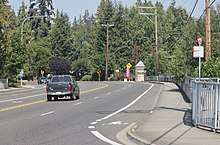
In 2009, the City of Bothell adopted plans to convert the southernmost blocks of SR 527 into a mixed-use boulevard and submitted a request to transfer the highway from the state control.[40] The proposed transfer received the recommendation of the state transportation commission in July 2010 and was passed by the state legislature in April 2011.[41] As a result, the southernmost 2.51 miles (4.04 km) of SR 527 was decommissioned from the state highway system and the highway's terminus was moved to I-405.[41] The $23 million boulevard, funded by a state grant and city revenue, was completed in August 2017 and added wider sidewalks, four sets of parallel parking lanes, a business access lane also designated for use by bicyclists, and medians to separate traffic.[42]
Major intersections
The entire highway is in Snohomish County.
| Location | mi[1] | km | Destinations | Notes | |
|---|---|---|---|---|---|
| Bothell | 0.00 | 0.00 | Continues south as Bothell–Everett Highway | ||
| 1.11 | 1.79 | ||||
| Mill Creek | 6.02 | 9.69 | |||
| 6.22 | 10.01 | ||||
| Everett | 8.99 | 14.47 | |||
| 9.29 | 14.95 | ||||
| 1.000 mi = 1.609 km; 1.000 km = 0.621 mi | |||||
References
- 1 2 Multimodal Planning Division (January 3, 2018). State Highway Log Planning Report 2017, SR 2 to SR 971 (PDF) (Report). Washington State Department of Transportation. pp. 1582–1590. Retrieved August 27, 2018.
- ↑ Kossen, Bill (May 28, 2002). "No more dot on the map; Commercial developers discover Bothell crossroads". The Seattle Times. p. C1.
- ↑ Haglund, Noah (June 4, 2016). "Rapid urban growth alters country life in North Creek area". The Everett Herald. Retrieved August 27, 2018.
- 1 2 3 Google (August 27, 2018). "State Route 527" (Map). Google Maps. Google. Retrieved August 27, 2018.
- 1 2 3 Washington State Department of Transportation (2014). Washington State Highways, 2014–2015 (PDF) (Map). Olympia: Washington State Department of Transportation. Puget Sound inset. Retrieved August 27, 2018.
- 1 2 Hinshaw, Mark (March 16, 2003). "New town center gives focus to a scattered community". The Seattle Times. p. G1.
- ↑ City of Mill Creek: Main City Map with Trails (PDF) (Map). 1 inch = 500 feet. City of Mill Creek. January 2017. Retrieved August 27, 2018.
- ↑ "SR 5 – Exit 189: Junction SR 99/SR 526/SR 527" (PDF). Washington State Department of Transportation. January 13, 2013. Retrieved August 27, 2018.
- ↑ 2016 Annual Traffic Report (PDF) (Report). Washington State Department of Transportation. 2017. p. 205. Retrieved August 27, 2018.
- ↑ "State Highway National Highway System Routes in Washington" (PDF). Washington State Department of Transportation. 2017. Retrieved August 27, 2018.
- ↑ "What is the National Highway System?". Federal Highway Administration. January 31, 2017. Retrieved August 27, 2018.
- ↑ Everett Transit System Map (Map). Everett Transit. March 2018. Retrieved August 27, 2018.
- ↑ Community Transit System Map (PDF) (Map). Community Transit. March 2018. Retrieved August 27, 2018.
- ↑ Slager, Melissa (November 27, 2017). "Community Transit starts construction on Green Line stations". The Everett Herald. Retrieved August 27, 2018.
- ↑ Seattle Quadrangle, Washington (Map). 1:125,000. United States Geological Survey. October 1897. Retrieved August 27, 2018.
- ↑ "Washington State's Historic State Roads: Historic Context for Island, Snohomish, King, Pierce, and Kitsap Counties" (PDF). Washington State Department of Archaeology and Historic Preservation. January 2014. pp. 208–209. Retrieved August 27, 2018.
- ↑ "Chapter 65: Classifying Public Highways" (PDF). Session Laws of the State of Washington, 1913. Washington State Legislature. March 12, 1913. p. 221. Retrieved August 30, 2018.
- 1 2 3 4 5 Brooks, Diane (May 25, 2006). "Loggers to latte stands: Route spans history". The Seattle Times. p. B4. Retrieved August 27, 2018.
- ↑ "Paved Highway to Everett Nears Completion". The Seattle Times. November 12, 1916. p. 6.
- ↑ "Chapter 185: Primary and Secondary State Highways" (PDF). Session Laws of the State of Washington, 1923. Washington State Legislature. March 19, 1923. pp. 628–629. Retrieved August 31, 2018.
- ↑ American Association of State Highway Officials (November 11, 1926). United States System of Highways Adopted for Uniform Marking by the American Association of State Highway Officials (Map). 1:7,000,000. Washington, DC: Bureau of Public Roads. OCLC 32889555. Retrieved August 31, 2018 – via University of North Texas Libraries.
- ↑ "New Highway Shortens Trip; Everett Road Open Oct. 15". The Seattle Times. August 29, 1927. p. 20.
- ↑ "Washington" (Map). Rand McNally Junior Auto Road Atlas. 1:1,500,000. Rand McNally. 1927. pp. 82–83. Seattle and Vicinity inset. OCLC 921180471. Retrieved August 31, 2018 – via David Rumsey Historical Map Collection.
- ↑ "Chapter 207: Classification of Public Highways" (PDF). Session Laws of the State of Washington, 1937. Washington State Legislature. March 18, 1937. p. 998. Retrieved August 31, 2018.
- ↑ "Chapter 239: Public Highways" (PDF). Session Laws of the State of Washington, 1943. Washington State Legislature. March 20, 1943. p. 721. Retrieved August 31, 2018.
- ↑ "Chapter 172: Highways" (PDF). Session Laws of the State of Washington, 1957. Washington State Legislature. March 21, 1957. p. 638. Retrieved August 30, 2018.
- ↑ C. G. Prahl (December 1, 1965). "Identification of State Highways" (PDF). Washington State Highway Commission. Retrieved September 9, 2018.
- ↑ Barr, Robert A. (October 6, 1969). "405 Freeway Link To Open Next Month". The Seattle Times. p. 7.
- ↑ Bergsman, Jerry (May 8, 1990). "Plans afoot to widen Bothell-Everett highway". The Seattle Times. p. E3.
- ↑ Keene, Linda (August 23, 1989). "Once-rural road now scene of showdown over growth". The Seattle Times. p. A1.
- 1 2 Tuinstra, Rachel (July 2, 2003). "City may condemn land for highway". The Seattle Times. p. H13.
- ↑ Bergsman, Jerry (November 1, 1990). "Relief is now in sight for motorists". The Seattle Times. p. F3.
- ↑ Bergsman, Jerry (February 4, 1991). "Bothell-Everett highway work may ease traffic, limits on growth". The Seattle Times. p. A1.
- ↑ Bergsman, Jerry (January 6, 1993). "Mill Creek roadwork to be revived". The Seattle Times. p. C3.
- ↑ "Projects aimed at aiding congestion". The Seattle Times. March 30, 1998. p. B2.
- ↑ "Council reconsiders traffic alternatives". The Seattle Times. October 26, 1989. p. C3.
- ↑ "SR 527 - 164th St. SE to 132nd St. SE Additional Lanes". Washington State Department of Transportation. Archived from the original on June 21, 2006. Retrieved September 26, 2008.
- 1 2 Kapralos, Krista (May 17, 2006). "Highway widening project completed". The Everett Herald.
- ↑ "SR 527 - 132nd St. SE to 112th St. SE - Complete May 2006". Washington State Department of Transportation. Archived from the original on December 16, 2006. Retrieved September 26, 2008.
- ↑ Steuteville, Robert (December 1, 2009). "Redesign of suburban arterial into boulevard in Bothell, WA". Congress for the New Urbanism. Retrieved September 10, 2018.
- 1 2 "Final Bill Report: HB 1520" (PDF). Washington State Legislature. May 2011. Retrieved September 10, 2018.
- ↑ Slager, Melissa (August 23, 2017). "Bothell leans European with its new multiway boulevard". The Everett Herald. Retrieved September 10, 2018.
External links
Route map: