Rovito
| Rovito | |
|---|---|
| Comune | |
| Comune di Rovito | |
 | |
.svg.png) Rovito within the Province of Cosenza | |
 Rovito Location of Rovito in Italy | |
| Coordinates: 39°18′32.76″N 16°19′12.36″E / 39.3091000°N 16.3201000°ECoordinates: 39°18′32.76″N 16°19′12.36″E / 39.3091000°N 16.3201000°E | |
| Country | Italy |
| Region | Calabria |
| Province | Cosenza (CS) |
| Frazioni | Bosco |
| Government | |
| • Mayor | Felice D'Alessandro |
| Area | |
| • Total | 10.68 km2 (4.12 sq mi) |
| Elevation | 740 m (2,430 ft) |
| Population (30 April 2017)[1] | |
| • Total | 3,137 |
| • Density | 290/km2 (760/sq mi) |
| Demonym(s) | Rovitesi |
| Time zone | UTC+1 (CET) |
| • Summer (DST) | UTC+2 (CEST) |
| Postal code | 87050 |
| Dialing code | 0984 |
| Patron saint | Santa Barbara |
| Website | Official website |
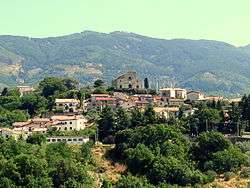
Rovito (Calabrian: Ruvìtu) is a town and comune in the province of Cosenza in the Calabria region of southern Italy.
Geography
The town is located in the western suburb of Cosenza, near the Sila mountain range. It borders with the municipalities of Casali del Manco, Celico, Cosenza, Lappano, San Pietro in Guarano and Zumpano. It counts the hamlet (frazione) of Bosco, a little village south of Cosenza.
References
External links
| Wikimedia Commons has media related to Rovito. |

This article is issued from
Wikipedia.
The text is licensed under Creative Commons - Attribution - Sharealike.
Additional terms may apply for the media files.