Borna, Leipzig
| Borna | ||
|---|---|---|
 | ||
| ||
 Borna Location of Borna within Leipzig district 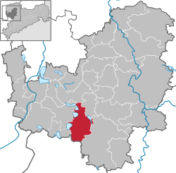 | ||
| Coordinates: 51°7′N 12°30′E / 51.117°N 12.500°ECoordinates: 51°7′N 12°30′E / 51.117°N 12.500°E | ||
| Country | Germany | |
| State | Saxony | |
| District | Leipzig | |
| • Mayor | (Left) | |
| Area | ||
| • Total | 62.35 km2 (24.07 sq mi) | |
| Elevation | 159 m (522 ft) | |
| Population (2017-12-31)[1] | ||
| • Total | 19,263 | |
| • Density | 310/km2 (800/sq mi) | |
| Time zone | CET/CEST (UTC+1/+2) | |
| Postal codes | 04552 | |
| Dialling codes | 0 34 33 | |
| Vehicle registration | L, BNA, GHA, GRM, MTL, WUR | |
| Website | www.borna.de | |

Borna (German pronunciation: [ˈbɔɐ̯naː]) is a town in the Free State of Saxony, Germany, capital of the Leipzig district. It is situated approximately 30 km southeast of Leipzig city. It has approx. 22,000 inhabitants. The town is the county seat of Leipzig County.
Geography
Borna is located about 30 km south of Leipzig. The river Wyhra flows through the town. The surrounding landscape has been influenced by open-cast coal mining.
The town lies in the middle of Central German Metropolitan Region, with Leipzig 33 km distant, Gera 50 km, Chemnitz 58 km, Halle 67 km, and Dresden 113 km. Neighboring large towns are Altenburg, 17 km away, Grimma, 24 km and Zeitz 35 km. Smaller towns and villages are shown below
Places adjacent to Borna, Leipzig | ||||||||||
|---|---|---|---|---|---|---|---|---|---|---|
| ||||||||||
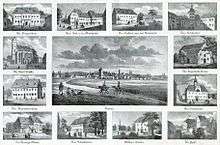
History
Pre-history and Middle Ages
The current site of Borna town was originally two settlements; Altstadt (the old town) and Wenigborn. Before the foundation of the town, there had been a water castle since the 9th Century. The first written mention of the town of Borna was recorded in 1251. Borna was burnt to the ground five times during the wars of the Middle Ages.
19th Century Onwards
Since the early 19th century the landscape around Borna has been shaped by open-cast mining of brown co
al (lignite) with an apex in the 1980s. For the last 20 years there have been huge efforts to revegetate this landscape e. g. by flooding opencast pits and creating new lakes as well as planting thousands of trees.
The industrialization of the town coincided with the start of lignite mining around 1800. The lignite industry was predominant in the region until recently.
Population
(December 31 each year)
| Year | Inhabitants | Year | Inhabitants | Year | Inhabitants |
|---|---|---|---|---|---|
| 1900 | 12,000 | ||||
| 1998 | 20,598 | 2005 | 22,428 | 2012 | 19,.424 |
| 1999 | 20,365 | 2006 | 22,561 | 2013 | 19,259 |
| 2000 | 20,010 | 2007 | 21,539 | 2014 | 19,381 |
| 2001 | 19,616 | 2008 | 21,211 | 2015 | 19,672 |
| 2002 | 19,240 | 2009 | 20,920 | 2016 | 19,319 |
| 2003 | 23,200 | 2010 | 20,680 | ||
| 2004 | 22,850 | 2011 | 20,405 |
Railway
On January 14, 1867, with the completion of the Borna-Neukieritzsch line, Borna joined the German railway network. From Neukieritszch the line connected with the Saxon-Bavarian railway line between Leipzig and Hof. This rail connection was financed by a partnership between private concerns and the town and was the only municipal railway in the Kingdom of Saxony. On April 8, 1872 the link was extended via Geithain to Chemnitz, creating the Neukieritzsch–Chemnitz railway.
In October 2007 the 14th century romanesque building of Emmaus Church in Heuersdorf (12 km or 7mil from Borna) was cut from the ground and relocated in Martin Luther Square of Borna . The church's journey took a number of days.
Main sights
- Kunigunden Church
- Emmaus Church on Luther square (moved from nearby Heuersdorf, which was resettled because of an open coal mine in 2008)
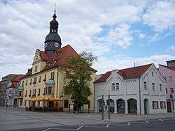
- Town hall
- Secondary school Gymnasium Am Breiten Teich
Gallery
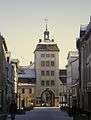 Reichstor - Imperial Gate
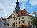 Borna Town Hall with Market Place
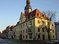 Borna Townhall
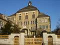 Borna secondary school
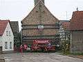 Emmaus Church on its way to Borna
Sons and daughters of the city
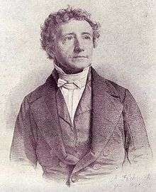
- Gustav Friedrich Dinter (1760-1831), theologian, educator
- Karl Immanuel Nitzsch (1767-1868), theologian
- Clemens Thieme (1861-1945), builder of the Volkerschlacht memorial in Leipzig
- Ludwig Külz (1875-1938), professor of tropical medicine
- Wilhelm Külz (1875-1948), politician (DDP, LDPD), MdR, Minister of the Interior
- Karl Möbius (1876-1953), German sculptor
- Wolfgang Heyl (1921-2014), politician (CDU)
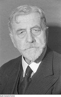
- Horst Pehnert (1932-2013), journalist and party official in the GDR
- Thomas Munkelt (born 1952), athlete, hurdler
- Maic Malchow (born 1962), railway cyclist
- Sven Lehmann (1965-2013), actor
- Torsten Jülich (born 1974), soccer player
- Steffen Radochla (born 1978), cyclist
- Oliver Herber (born 1981), soccer player
References
- ↑ "Aktuelle Einwohnerzahlen nach Gemeinden 2017] (Einwohnerzahlen auf Grundlage des Zensus 2011)" (PDF). Statistisches Landesamt des Freistaates Sachsen (in German). October 2018.
External links


Towns and municipalities in Leipzig (district) | ||
|---|---|---|
| Authority control |
|---|