Bonanza Hills, Texas
| Bonanza Hills, Texas | |
|---|---|
| Census-designated place | |
 Bonanza Hills | |
| Coordinates: 27°47′41″N 99°28′10″W / 27.79472°N 99.46944°WCoordinates: 27°47′41″N 99°28′10″W / 27.79472°N 99.46944°W | |
| Country | United States |
| State | Texas |
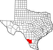
| County | Webb |
| Area | |
| • Total | 1.11 sq mi (2.9 km2) |
| • Land | 1.11 sq mi (2.9 km2) |
| • Water | 0.00 sq mi (0.0 km2) |
| Elevation | 715 ft (218 m) |
| Population (2010) | |
| • Total | 37 |
| Time zone | UTC-6 (Central (CST)) |
| • Summer (DST) | UTC-5 (CDT) |
| ZIP code | 78045 |
| GNIS feature ID | 2584612[1] |
Bonanza Hills is a census-designated place in Webb County, Texas, United States. The population was 37 at the 2010 census.[2] This was a new CDP formed from parts of the Botines CDP and additional area prior to the 2010 census.[3]
Geography
Bonanza Hills is located at 27°47′41″N 99°28′10″W / 27.79472°N 99.46944°W (27.794768, -99.469502) along U.S. Highway 83 in north-central Webb County.
According to the United States Census Bureau, the CDP has a total area of 1.11 square miles (2.9 km2), all land.[2]
References
- ↑ U.S. Geological Survey Geographic Names Information System: Bonanza Hills, Texas
- 1 2 "Profile of General Population and Housing Characteristics: 2010 Demographic Profile Data (DP-1): Bonanza Hills CDP, Texas". U.S. Census Bureau, American Factfinder. Archived from the original on September 11, 2013. Retrieved January 21, 2016.
- ↑ "Population and Housing Unit Counts, 2010 Census of Population and Housing" (PDF). Texas: 2010. Retrieved 2017-01-03.
This article is issued from
Wikipedia.
The text is licensed under Creative Commons - Attribution - Sharealike.
Additional terms may apply for the media files.