Bolton Low Houses
| Bolton Low Houses | |
|---|---|
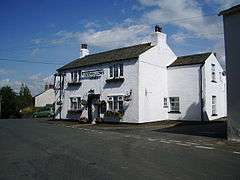 Oddfellows Arms, Bolton Low Houses | |
 Bolton Low Houses Bolton Low Houses shown within Cumbria | |
| OS grid reference | NY236443 |
| Civil parish | |
| District | |
| Shire county | |
| Region | |
| Country | England |
| Sovereign state | United Kingdom |
| Post town | WIGTON |
| Postcode district | CA7 |
| Dialling code | 01697 |
| Police | Cumbria |
| Fire | Cumbria |
| Ambulance | North West |
| EU Parliament | North West England |
| UK Parliament | |
Bolton Low Houses is a small village in Cumbria, England. It is located 3.1 miles (5.0 km) by road to the southwest of South End.[1] There is a coal mining area to the east between Oughterside, [2][3] Allhallows Colliery and Bolton No.2 Pit.[4] In 1831, Samuel Lewis noted that there was a meeting house for dissenters in Bolton Low Houses.[5] It contains a Methodist Chapel and a pub, the Oddfellows Arms.[6]
See also
References
- ↑ Maps (Map). Google Maps.
- ↑ Great Britain. Royal Commission on Coal Supplies (1904). Reports. H. M. Stationery Office. p. 99. Retrieved 9 July 2012.
- ↑ North of England Institute of Mining and Mechanical Engineers (1896). Transactions. p. 110. Retrieved 9 July 2012.
- ↑ North of England Institute of Mining and Mechanical Engineers (1884). Transactions - North of England Institute of Mining and Mechanical Engineers. p. 132. Retrieved 9 July 2012.
- ↑ Lewis, Samuel (1831). A topographical Dictionary of England. Lewis. p. 182. Retrieved 9 July 2012.
- ↑ Parson, William; White, William (1976). A history, directory, and gazetteer of Cumberland and Westmorland: with that part of the Lake District in Lancashire, forming the Lordships of Furness and Cartmel. Michael Moon. Retrieved 9 July 2012.
This article is issued from
Wikipedia.
The text is licensed under Creative Commons - Attribution - Sharealike.
Additional terms may apply for the media files.