Bollons Seamount
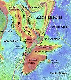
Bollons Seamount is a seamount just east of the international date line, a few hundred miles off the coast of New Zealand.[1] It represents a continental fragment that was separated from Zealandia by rifting.[2] The seamount was involved in a 2002 survey and collection project defined to find the edge of New Zealand's continental shelf.[3] The Bollons Seamount has been shown to be a site of extensive Cretaceous-era rifting in the area towards the southern Chatham Rise between 83.7 and 78.5 MYA.[4]
Magnetic anomalies from the seamount indicate that it was the site of highly irregular activity, with differences in the rifting there being up to 100 km (62 mi). A 50 km (31 mi) gap near the seamount, known as the Ballons gap, is interpreted as being due to excess volcanism from the seafloor spreading process. A ridge just south of the seamount, the Antipodes Fracture Zone, is interpreted as having been built by a combination of compression and volcanic activity associated with the triple-junction Bellingshausen-Marie Byrd Land plate boundary nearby.[4]
References
- ↑ "Google Maps". Google. Retrieved 22 July 2010.
- ↑ Sutherland, Rupert (1999). "Basement geology and tectonic development of the greater New Zealand region: an interpretation from regional magnetic data". Tectonophysics. 308 (3): 341–362. Bibcode:1999Tectp.308..341S. doi:10.1016/S0040-1951(99)00108-0.
- ↑ "Hydrographic Report Number crunching time for Continental Shelf Project". 2002. Archived from the original on 26 May 2010. Retrieved 22 July 2010.
- 1 2 Davy, B. (2006). "Bollons Seamount and early New Zealand–Antarctic seafloor spreading". Geochem. Geophys. Geosyst. 7: Q06021. Bibcode:2006GGG.....7.6021D. doi:10.1029/2005GC001191.
External links
- Bollons Seamount at the Seamount database published by Earthref, a National Science Foundation project