Bois d'Arc, Kansas
| Bois d'Arc, Kansas | |
|---|---|
| Unincorporated community | |
 KDOT map of Butler County (legend) | |
| Coordinates: 37°35′47″N 96°55′31″W / 37.59639°N 96.92528°WCoordinates: 37°35′47″N 96°55′31″W / 37.59639°N 96.92528°W[1] | |
| Country | United States |
| State | Kansas |
| County | Butler |
| Township | Bloomington |
| Elevation[1] | 1,224 ft (373 m) |
| Time zone | UTC-6 (CST) |
| • Summer (DST) | UTC-5 (CDT) |
| Area code | 316 |
| FIPS code | 20-07860 [1] |
| GNIS feature ID | 0484710 [1] |


Bois d'Arc is an unincorporated community in Butler County, Kansas, United States.[1] The town is a few miles south and east of Augusta, Kansas. It is located in Bloomington Township, Butler County, Kansas.
History
_Kansas.jpg)
The name Bois d'Arc is taken from one of the names for a common tree in the area, the Osage Orange tree. The Osage Indians used these trees to make their bows.[2]
The post office was established December 21, 1892, and was discontinued March 31, 1904.
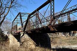
The nearby Little Walnut River Pratt Truss Bridge is on the National Register of Historic Places. According to the National Register of Historic Places registration form, the bridge crosses Little Walnut Creek, one mile below where Hickory Creek flows into it. This is on SW 157th Terrace between SW Commanche Road and SW Purity Springs Road.[3] The remains of a grist mill can be found upstream.[4]
The name and spelling of the town was eventually corrupted to Boder.[5] Later, the spelling of the town name changed to "Bodarc" reflecting its present-day pronunciation.
Remaining structures in Bois d'Arc comprise the former post office, a farmhouse, the bridge, and the ruins of the grist mill.
See also
Further reading
References
- 1 2 3 4 5 Geographic Names Information System (GNIS) details for Bois d'Arc, Kansas; United States Geological Survey (USGS); October 13, 1978.
- ↑ "Osage orange". Encyclopædia Britannica. Retrieved 12 August 2015.
- ↑ "National Register of Historic Places Registration Form: Little Walnut River Pratt Truss Bridge" (PDF). United States National Park Service. Retrieved 12 August 2015.
- ↑ Mooney, Vol (1916). /History of Butler County, Kansas 1916. Vol. P. Mooney, Bloomington Township History of Butler County Kansas Check
|url=value (help). Standard Publishing Company. - ↑ "Standard atlas of Butler County, Kansas: Map of Bloomington Township". Kansas Historical Society. Retrieved 12 August 2015.
Further reading
- County
- History of Butler County Kansas; Vol P Mooney; Standard Publishing; 869 pages; 1916. (Download 68MB PDF eBook)
- Kansas
- History of the State of Kansas; William G. Cutler; A.T. Andreas Publisher; 1883. (Online HTML eBook)
- Kansas : A Cyclopedia of State History, Embracing Events, Institutions, Industries, Counties, Cities, Towns, Prominent Persons, Etc; 3 Volumes; Frank W. Blackmar; Standard Publishing Co; 944 / 955 / 824 pages; 1912. (Volume1 - Download 54MB PDF eBook), (Volume2 - Download 53MB PDF eBook), (Volume3 - Download 33MB PDF eBook)
External links
Municipalities and communities of Butler County, Kansas, United States | ||
|---|---|---|
| Cities | 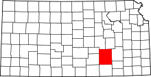 | |
| Unincorporated communities | ||
| Ghost towns | ||
| Townships | ||
| Footnotes | †This populated place is designated a Census-Designated Place (CDP) by the United States Census Bureau, ‡This populated place also has portions in an adjacent county or counties. | |