Blue Ridge Mountain, Pennsylvania
| Nesquehoning Mountain[1] | |
|---|---|
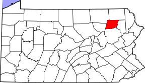 Location of Wyoming County Pennsylvania and Blue Ridge Mountain, well away from the Blue Mountain Ridge and the Blue Ridge Mountains of Virginia.
| |
| Highest point | |
| Elevation | 1,171[2] ft (357 m) |
| Coordinates | 41°36′28″N 76°05′35″W / 41.60778°N 76.09306°WCoordinates: 41°36′28″N 76°05′35″W / 41.60778°N 76.09306°W |
| Dimensions | |
| Length | 25 mi (40 km) east-west |
| Width | 1–2 km (0.62–1.24 mi) north-south |
| Geography | |
| Country | United States |
| State | Pennsylvania |
| Borders on | Ridge-and-Valley Appalachians and Glaciated Low Plateau Section |
| Geology | |
| Orogeny | Appalachian Mountains |
| Age of rock | ?Silurian? |
| Type of rock | ?Tuscarora Formation? and ?Shawangunk Formation?; sedimentary |
Blue Ridge Mountain is an isolated single peak in Wyoming County, Pennsylvania overlooking a loop of the Main Branch Susquehanna River in the sparsely settled Endless Mountains in Northeastern Pennsylvania a couple of miles west of Meshoppen at latitude, longitude coordinates: 41.6078537, -76.0929827 overlooking the northern end of the Wyoming Valley region.[2] US Route 6, a main E-W secondary highway and the railroad tracks built by the Lehigh Valley Railroad once followed by the famous Black Diamond Express named luxury trains on their daily runs from New York City to Buffalo, NY passes by its foot between the summit and the left bank (north) of the Susquehanna River.
References
Municipalities and communities of Wyoming County, Pennsylvania, United States | ||
|---|---|---|
| Boroughs | | |
| Townships | ||
| CDPs | ||
| Unincorporated communities | ||
| Ghost town | ||
This article is issued from
Wikipedia.
The text is licensed under Creative Commons - Attribution - Sharealike.
Additional terms may apply for the media files.