Bloomington, Kansas
| Bloomington, Kansas | |
|---|---|
| Unincorporated community | |
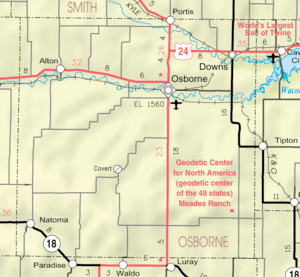 KDOT map of Osborne County (legend) | |
 Bloomington  Bloomington | |
| Coordinates: Coordinates: 39°27′14″N 98°47′20″W / 39.454°N 98.789°W | |
| Country | United States |
| State | Kansas |
| County | Osborne |
| Time zone | UTC-6 (CST) |
| • Summer (DST) | UTC-5 (CDT) |
| Area code | 785 |
Bloomington is an unincorporated community in Osborne County, Kansas, in the United States.[1] It is located about 4 miles west of Osborne.
History
Bloomington was originally called "Tilden", and under the latter name was platted in 1871.[2] The present name of "Bloomington" was adopted in 1873.[2] A post office was opened in Bloomington in the 1870s, and remained in operation until it was discontinued in 1955.[3]
Education
Bloomington grade school was closed in 1968.[4]
References
- ↑ "Osborne County". Blue Skyways. Kansas State Library. Retrieved 21 June 2014.
- 1 2 "Origin of Town Names" (PDF). Solomon Valley Highway 24 Heritage Alliance. p. 3. Retrieved 9 April 2018.
- ↑ "Kansas Post Offices, 1828-1961". Kansas Historical Society. Archived from the original on October 9, 2013. Retrieved 21 June 2014.
- ↑ "Bloomington attendance center closed", Osborne County Farmer, August 22, 1968, p. 1.
Municipalities and communities of Osborne County, Kansas, United States | ||
|---|---|---|
| Cities | 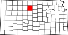 | |
| Unincorporated communities | ||
| Ghost towns | ||
| Townships |
| |
This article is issued from
Wikipedia.
The text is licensed under Creative Commons - Attribution - Sharealike.
Additional terms may apply for the media files.