Black River (Hastings County)
| Black River | |
| River | |
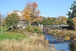 Dam and old mill at Queensborough | |
| Country | Canada |
|---|---|
| Province | Ontario |
| Region | Central Ontario |
| County | Hastings |
| Part of | Great Lakes Basin |
| Tributaries | |
| - right | West Black River |
| Source | Unnamed lake |
| - location | Tudor and Cashel |
| - elevation | 393 m (1,289 ft) |
| - coordinates | 43°53′50″N 77°31′24″W / 43.89722°N 77.52333°W |
| Mouth | Moira River |
| - location | Tweed |
| - elevation | 155 m (509 ft) |
| - coordinates | 44°31′47″N 77°22′16″W / 44.52972°N 77.37111°WCoordinates: 44°31′47″N 77°22′16″W / 44.52972°N 77.37111°W |
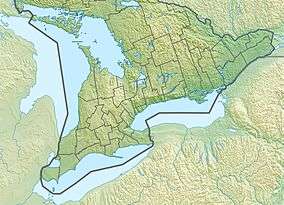 Location of the mouth of the Black River in southern Ontario | |
The Black River is a river in Hastings County in Central Ontario, Canada.[1] It is part of the Great Lakes Basin, and is a left tributary of the Moira River.
Course
The river begins at an unnamed lake in geographic Cashel Township,[2] part of the municipality of Tudor and Cashel, and 2.2 kilometres (1.4 mi) northeast of the community of Gunter. It flows south then southeast, passes into geographic Grimsthorpe Township[3] in the municipality of Tweed, and reaches Lingham Lake. It leaves the lake at the south and flows south into geographic Elzevir Township,[4] where it takes in the right tributary West Black River, arcs briefly west into the municipality of Madoc,[5] then returns east into Elzevir Township near the community of Queensborough. The river there goes over a weir, continues south through a series of rapids, heads under Ontario Highway 7, and reaches its mouth at the Moira River. The Moira River flows to the Bay of Quinte on Lake Ontario.
Recreation
The river is used by whitewater paddlers, particularly in spring as part of the M.A.C.K.fest (Marmora Area Canoe and Kayak Festival),[6][7] with the community of Queensborough serving as a friendly access point recognized by Whitewater Ontario.[8][9]
Tributaries
- Railway Creek (right)
- Queensborough Creek (left)
- West Black River (right)
- Canniff Creek (left)
See also
References
- ↑ "Black River". Geographical Names Data Base. Natural Resources Canada. Retrieved 2014-06-06.
- ↑ "Cashel" (PDF). Geology Ontario - Historic Claim Maps. Ontario Ministry of Northern Development, Mines and Forestry. Archived from the original (PDF) on 2014-07-14. Retrieved 2014-06-06.
- ↑ "Grimsthorpe" (PDF). Geology Ontario - Historic Claim Maps. Ontario Ministry of Northern Development, Mines and Forestry. Archived from the original (PDF) on 2014-07-14. Retrieved 2014-06-06.
- ↑ "Elzevir" (PDF). Geology Ontario - Historic Claim Maps. Ontario Ministry of Northern Development, Mines and Forestry. Archived from the original (PDF) on 2014-07-14. Retrieved 2014-06-06.
- ↑ "Madoc" (PDF). Geology Ontario - Historic Claim Maps. Ontario Ministry of Northern Development, Mines and Forestry. Archived from the original (PDF) on 2014-07-14. Retrieved 2014-06-06.
- ↑ "Queensborough". 2010. Retrieved 2014-06-06.
- ↑ "Black River". Marmora Area Canoe and Kayak Festival. Retrieved 2014-06-06.
- ↑ "Things to do". Queensborough Community Centre. Retrieved 2014-06-06.
- ↑ "Media coverage of WO Advocacy sign unveiling". Whitewater Ontario. 2012-04-30.
Other map sources:
- Map 6 (PDF) (Map). 1 : 700,000. Official road map of Ontario. Ministry of Transportation of Ontario. 2010-01-01. Retrieved 2014-06-06.
- Restructured municipalities - Ontario map #5 (Map). Restructuring Maps of Ontario. Ontario Ministry of Municipal Affairs and Housing. 2006. Retrieved 2014-06-06.