Bighorn River (Alberta)
| Bighorn River | |
|---|---|
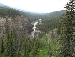 Bighorn River Valley and Crescent Falls | |
| Country |
|
| Physical characteristics | |
| Main source |
Bighorn Meadows 1,985 m (6,512 ft) 52°17′34″N 116°32′39″W / 52.29278°N 116.54417°W |
| River mouth |
North Saskatchewan River 1,216 m (3,990 ft) 52°21′17″N 116°14′51″W / 52.35472°N 116.24750°WCoordinates: 52°21′17″N 116°14′51″W / 52.35472°N 116.24750°W |
The Bighorn River is a short river originating in the Alberta foothills, and is a tributary of the North Saskatchewan River. The river, as well as the nearby Bighorn Range and Bighorn Dam are named for the Bighorn sheep which dominate the area. The name first appeared in 1865.[1]
Flowing under Mount McGuire, Bighorn River soon takes on Littlehorn and Sunkay Creeks, before plummeting over the impressive Crescent Falls. After the falls, the Bighorn travels through a significant canyon, before passing through the Bighorn Indian Reserve. The river then empties into the North Saskatchewan River after Lake Abraham.[2]
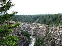
The Bighorn River Canyon
See also
References

This article is issued from
Wikipedia.
The text is licensed under Creative Commons - Attribution - Sharealike.
Additional terms may apply for the media files.