Bethelsdorp
| Bethelsdorp | |
|---|---|
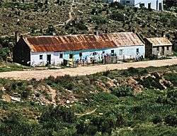 Almshouses, Alms Street, Bethelsdorp | |
 Bethelsdorp  Bethelsdorp Bethelsdorp (South Africa)  Bethelsdorp Bethelsdorp (Africa) | |
| Coordinates: 33°53′S 25°30′E / 33.883°S 25.500°ECoordinates: 33°53′S 25°30′E / 33.883°S 25.500°E | |
| Country | South Africa |
| Province | Eastern Cape |
| Municipality | Nelson Mandela Bay |
| Established | 1803 |
| Area[1] | |
| • Total | 36.62 km2 (14.14 sq mi) |
| Population (2011)[1] | |
| • Total | 182,012 |
| • Density | 5,000/km2 (13,000/sq mi) |
| Racial makeup (2011)[1] | |
| • Black African | 34.1% |
| • Coloured | 64.4% |
| • Indian/Asian | 0.6% |
| • White | 0.2% |
| • Other | 0.8% |
| First languages (2011)[1] | |
| • Afrikaans | 57.8% |
| • Xhosa | 28.7% |
| • English | 11.2% |
| • Other | 2.3% |
| Time zone | UTC+2 (SAST) |
| Postal code (street) | 6059 |
| PO box | 6003 |
| Area code | +27 (0)41 |
Bethelsdorp is a town in Nelson Mandela Bay Metropolitan Municipality in the Eastern Cape province of South Africa, 20 km north-west of Port Elizabeth.
History
Established in 1803 by Rev. J. T. van der Kemp on the farm Roodepas of Theunis Botha as a mission station of the London Missionary Society. The name is derived from the Hebrew word Baitheel, meaning 'House of God'.[2]
Under the previous political dispensation, Bethelsdorp was a township almost exclusively inhabited by coloureds (Afrikaans: Kleurlinge). This changed somewhat with the end of Apartheid in South Africa in 1994, as living and trading in the township is now freely open to all races.
References
- 1 2 3 4 "Main Place Bethelsdorp". Census 2011.
- ↑ "Dictionary of Southern African Place Names (Public Domain)". Human Science Research Council. p. 78.
Municipalities and communities of Nelson Mandela Bay Metropolitan Municipality, Eastern Cape | ||
|---|---|---|
District seat: Port Elizabeth | ||
| Cities and towns | .svg.png) | |
This article is issued from
Wikipedia.
The text is licensed under Creative Commons - Attribution - Sharealike.
Additional terms may apply for the media files.