Bernina Pass
| Bernina Pass | |
|---|---|
 View from the top of the pass in the direction of Pontresina, Switzerland | |
| Elevation | 2,328 m (7,638 ft) |
| Traversed by | Road, rail (2253 m.) |
| Location | Graubünden, Switzerland |
| Range | Alps |
| Coordinates | 46°24.744′N 10°1.71′E / 46.412400°N 10.02850°ECoordinates: 46°24.744′N 10°1.71′E / 46.412400°N 10.02850°E |
 Bernina Pass Location in Switzerland | |
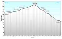
The Bernina Pass (el. 2,328 m or 7,638 ft.) (Italian: Passo del Bernina) is a high mountain pass in the Bernina Range of the Alps, in the canton of Graubünden (Grisons) in eastern Switzerland. It connects the famous resort town of St. Moritz in the Engadin valley with the Italian-speaking Val Poschiavo, which ends in the Italian town of Tirano in Valtellina. The pass lies a few kilometres east of Piz Bernina.
The Bernina Pass is crossed by road and rail, with a popular tourist train, the Bernina Express operating year-round between Chur and Tirano. The train crosses the pass west of the road at a slightly lower 2,253 metres (7,392 ft) (at Ospizio Bernina) - it is the highest adhesion railway route in Europe.
Lago Bianco, Lej Nair and Lej Pitschen are located on the pass.
History
The pass was an important trade route over the Alps during the Middle Ages. In 1410 several communities north and south of the pass agreed to work together to maintain it. In 1512 the Three Leagues and their Swiss allies invaded the Valtellina region through the Bernina Pass. At this time the first road over the pass was mentioned. It covered a distance of about 20 miles (32 km) from Poschiavo to Pontresina.[1]
The building of the road began in 1842. Head of engineers was Rudolf Albertini (1821–1896) from Zuoz. The work was finished in 1865 and hospice at an elevation of 2,307 metres (7,569 ft) was also opened. Since this time road was made broader several times, since 1965 it is open all the year, although there is snow during 8 months.
Climate
| Climate data for Passo del Bernina (1981-2010) | |||||||||||||
|---|---|---|---|---|---|---|---|---|---|---|---|---|---|
| Month | Jan | Feb | Mar | Apr | May | Jun | Jul | Aug | Sep | Oct | Nov | Dec | Year |
| Average high °C (°F) | −3.7 (25.3) |
−3.7 (25.3) |
−1.4 (29.5) |
1.5 (34.7) |
7.0 (44.6) |
11.1 (52) |
14.0 (57.2) |
13.4 (56.1) |
9.4 (48.9) |
5.5 (41.9) |
−0.2 (31.6) |
−3.0 (26.6) |
4.2 (39.6) |
| Daily mean °C (°F) | −7.2 (19) |
−7.5 (18.5) |
−5.3 (22.5) |
−2.4 (27.7) |
2.7 (36.9) |
6.4 (43.5) |
9.2 (48.6) |
8.9 (48) |
5.2 (41.4) |
1.7 (35.1) |
−3.5 (25.7) |
−6.3 (20.7) |
0.2 (32.4) |
| Average low °C (°F) | −10.8 (12.6) |
−11.2 (11.8) |
−8.8 (16.2) |
−5.5 (22.1) |
−0.6 (30.9) |
2.8 (37) |
5.6 (42.1) |
5.4 (41.7) |
2.4 (36.3) |
−1.0 (30.2) |
−6.3 (20.7) |
−9.6 (14.7) |
−3.1 (26.4) |
| Average precipitation mm (inches) | 109 (4.29) |
83 (3.27) |
110 (4.33) |
165 (6.5) |
175 (6.89) |
160 (6.3) |
146 (5.75) |
149 (5.87) |
152 (5.98) |
178 (7.01) |
187 (7.36) |
125 (4.92) |
1,738 (68.43) |
| Average snowfall cm (inches) | 107.4 (42.28) |
86 (33.9) |
105.4 (41.5) |
146.1 (57.52) |
49.1 (19.33) |
9.6 (3.78) |
2.1 (0.83) |
2.1 (0.83) |
9.7 (3.82) |
46.3 (18.23) |
114 (44.9) |
113.9 (44.84) |
791.7 (311.69) |
| Average precipitation days (≥ 1.0 mm) | 7.6 | 6.9 | 7.9 | 10.6 | 13.1 | 11.5 | 11.4 | 12.0 | 9.3 | 10.5 | 9.5 | 8.5 | 118.8 |
| Average snowy days (≥ 1.0 cm) | 8 | 7.9 | 8.9 | 11 | 5.3 | 1.6 | 0.3 | 0.4 | 1.8 | 5.2 | 9.2 | 8.5 | 68.1 |
| Average relative humidity (%) | 63 | 65 | 67 | 72 | 72 | 69 | 67 | 70 | 71 | 70 | 68 | 66 | 68 |
| Source: MeteoSwiss [2] | |||||||||||||
Gallery
.JPG) Bernina Pass & Lago Bianco
Bernina Pass & Lago Bianco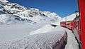 Bernina Pass by train in winter
See also
References
- ↑ Bernina Pass in German, French and Italian in the online Historical Dictionary of Switzerland.
- ↑ "Climate Norm Value Tables". Climate diagrams and normals from Swiss measuring stations. Federal Office of Meteorology and Climatology (MeteoSwiss). Retrieved 5 January 2016. The weather station elevation is 2307 meters above sea level.
External links
- Swisstopo map of the pass
- Pictures from the Bernina Pass Mountainbike Route
- Profile on climbbybike.com
- Bernina Pass in Romansh, German, French and Italian in the online Historical Dictionary of Switzerland.
