Bennison Island
 | |
 Bennison Island | |
| Geography | |
|---|---|
| Location | Corner Inlet |
| Coordinates | 38°50′33″S 146°22′09″E / 38.8425°S 146.3693°ECoordinates: 38°50′33″S 146°22′09″E / 38.8425°S 146.3693°E |
| Area | 7.7 ha (19 acres)[1] |
| Length | 300 m (1,000 ft)[1] |
| Width | 250 m (820 ft)[1] |
| Highest elevation | 46 m (151 ft)[1] |
| Administration | |
|
Australia | |
| State | Victoria |
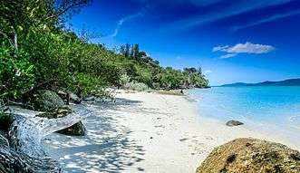
Bennison's Southern Beach
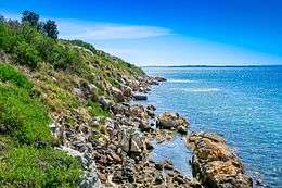
Bennison Island is an uninhabited granite island in Corner Inlet near the northern coast of Wilsons Promontory, in Victoria, Australia.[1]
Access is by boat at high tide.
The island is part of Wilsons Promontory National Park [1] and the surrounding waters are within Corner Inlet Marine National Park and Corner Inlet Marine and Coastal Park.[2]
External links
References
- 1 2 3 4 5 6 Norman, F. I. (September 1977). "Seabird Islands No 47, Benison Island, Corner Inlet, Victoria" (PDF). Corella. 1 (3): 56–57.
- ↑ "Corner Inlet Marine National Park management plan" (PDF). Parks Victoria (PDF). Government of Victoria. September 2005. ISBN 0-7311-8345-2. Retrieved 4 February 2012.
Islands of Victoria, Australia | |||||||||||
|---|---|---|---|---|---|---|---|---|---|---|---|
| Islands off East Gippsland | |||||||||||
| Islands within Corner Inlet |
| ||||||||||
| Islands off Wilsons Promontory |
| ||||||||||
| Islands within Western Port | |||||||||||
| Islands within Port Phillip | |||||||||||
| Islands within Bass Strait and the Great Australian Bight | |||||||||||
| River islands | |||||||||||
| |||||||||||
This article is issued from
Wikipedia.
The text is licensed under Creative Commons - Attribution - Sharealike.
Additional terms may apply for the media files.