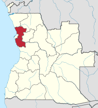
Bengo Province
| Bengo | |
|---|---|
| Province | |
 Bengo, province of Angola | |
| Country | Angola |
| Capital | Caxito |
| Area | |
| • Total | 31,371 km2 (12,112 sq mi) |
| Population (2014 census) | |
| • Total | 351,579 |
| • Density | 11/km2 (29/sq mi) |
| ISO 3166 code | AO-BGO |
| Website |
www |
Coordinates: 8°47′S 13°59′E / 8.783°S 13.983°E
Bengo is a province of Angola. Its capital is Caxito. According to 1988 statistics, there were 18,700 people living in urban areas with 137,400 in rural areas, with a total of 156,100 residents.[1] It has an area of 31,371 square kilometres, and its population at the 2014 Census was 351,579. The province had been created in 1980 by dividing the original province Luanda into Bengo and the then smaller province Luanda.[2]
Geography
The province is bordered by the provinces of Zaire to the North, Uige to the Northeast, Cuanza Norte to the East, and Cuanza Sul to the South. It has two western coastal stretches along the Atlantic Ocean, and forms an enclave around the national capital's province of Luanda. The Kissama National Park and the Kibinda Forest Reserve are here. The province also has a number of lakes, most of them are in the municipalities of Dande and Icolo and Bengo. There are lagoons at Panguila and Ibendoa, Cabiri and Ulua do Sungui.
Municipalities
Since the territorial reform of July 2011
The Angolan National Assembly approved a law on July 27, 2011 reorganizing the territorial subdivisions of Luanda and Bengo provinces .[2] The law moved the Icolo e Bengo and Quiçama municipalities from Bengo province to Luanda province and created new municipalities in both provinces. Now, Bengo is divided into six municipalities: Ambriz, Bula-Atumba, Dande, Dembos, Nambuangongo, and Pango Aluquém.[3]
Before the territorial reform of 2011
The province of Bengo contained five municipalities (municípios):[4]
| Município | Capital[5] | Area (km2)[5] | Pop. (2006 est)[5] |
|---|---|---|---|
| Ambriz | Ambriz | 4,204 | 16,611 |
| Dande | Caxito | 6,529 | 82,992 |
| Ícolo e Bengo | Catete | 3,819 | 58,830 |
| Nambuangongo | Muxaluando | 5,604 | 110,831 |
| Quiçama | Muxima | 12,046 | 29,905 |
Icolo e Bengo and Quiçama have been moved to Luanda Province in 2011.
Some sources also show the following municipalities in Bengo province: Bula-Atumba,[5] Dembos,[5][6] and Pango-Aluquém,[5][6] while others list those three in Cuanza Norte (Kwanza Norte) province.[4]
Communes
The province of Bengo contains the following communes (comunas):[7]
Natural resources
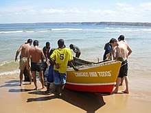
Bengo is known by the abundant fishes, with a few fishing communities along the coast. From this region was found the first dinosaur fossil skeleton from Angola: the Angolatitan.[8]
See also
References
- ↑ "About this Collection - Country Studies". The Library of Congress. Retrieved 2017-07-09.
- 1 2 National Assembly of Angola (27 July 2011). "Lei n.º 29/11 de 1 de Setembro - Alteração da Divisão Político-Administrativa das províncias de Luanda e Bengo" [Law to change the politico-administrative divisions of Luanda and Bengo provinces] (PDF) (in Portuguese). IPGUL 'Noticias'. Retrieved 20 March 2012. While the law had been voted on July 27, 2011, its effective date is 60 days after publication in the Official Journal, which happened on September 1, 2011.
- ↑ "Bengo". Retrieved 20 March 2012.
- 1 2 "Reference Center: Provinces". Angolan Embassy in the United States. Archived from the original on 11 February 2006.
- 1 2 3 4 5 6 Angola Statistics: Bengo. GeoHive. Source: Instituto Nacional de Estatística, Angola. Instituto Nacional de Segurança Social, Angola.
- 1 2 "Bengo: Municípios". Info-Angola. Archived from the original on 2009-12-22. Retrieved 27 Feb 2010.
- ↑ "Bengo: Comunas". Info-Angola. Retrieved 27 Feb 2010.
- ↑ O Mateus, LL Jacobs, AS Schulp, MJ Polcyn, TS Tavares, A Buta Neto, 2011. Angolatitan adamastor, a new sauropod dinosaur and the first record from Angola. Anais da Academia Brasileira de Ciências 83 (1), 221-233.
External links
- Official website of province governor
- Information on this province at the Angolan ministry for territorial administration
- Information on this province at Info Angola
- "Province of Bengo". Embassy of Angola UK. Archived from the original on 2008-08-02.
- US government statistics from 1988
- "Map of communes in Bengo" (PDF). from Info-Angola
- - Defence Minister's visit
- Province geographical info at geoview.info
Capital: Caxito | |
| Ambriz |
|
| Bula Atumba |
|
| Dande | |
| Dembos | |
| Nambuangongo | |
| Pango-Aluquém |
|